Val di Zoldo
| Val di Zoldo | ||
|---|---|---|
|
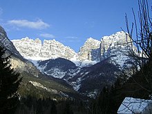
Forno di Zoldo in the middle section of the valley with the Bosconero group in the background |
||
| location | Belluno Province , Veneto , Italy | |
| Waters | Torrente Maè | |
| Mountains | Dolomites | |
| Geographical location | 46 ° 17 ′ 20 ″ N , 12 ° 14 ′ 17 ″ E | |
|
|
||
| Type | Kerbtal | |
| rock | Sedimentary rocks | |
| height | 473 to 3220 m slm | |
The Val di Zoldo (also Val Zoldana ) is a valley in the southern Dolomites . The valley lies entirely in the province of Belluno .
The Val di Zoldo runs roughly in a north-west-south-east direction. The main river is the Torrente Maè . After about 32 km it flows into the Piave , the mouth is located immediately south of the center of Longarone .
Communities
The valley essentially comprises the municipality of the same name, Val di Zoldo . The valley also includes the territory of the municipality of Zoppè di Cadore and, downstream, part of the municipality of Longarone.
geography
The Torrente Maè rises at the foot of the Civetta ( 3220 m slm ), whose massif borders the valley in the northwest. The northern end is the Monte Pelmo ( 3168 m ). Its massifs are the only ones in the valley that exceed the 3000 meter mark.
To the south of the Civetta is the Moiazza group, whose highest peak is the 2878 m high Cime Moiazza . To the southwest of it, the Schiara group ( 2565 m ) borders the Val di Zoldo. The opposite north-eastern and eastern boundary of the valley is formed after Monte Pelmo by the smaller peaks Monte Pénna ( 2196 m ) and Monte Rite ( 2183 m ), then mainly by the Bosconero group , the highest peak of which is the Sasso di Bosconero ( 2468 m ) is. Further peaks with heights of more than 2000 meters border the valley.
traffic
The full length of the valley is traversed by Strada provinciale 251. The northwestern apex of the valley is the Staulanzapass , which borders the Val di Zoldo to the north. In the direction of the north-western Valle del Boite there is a connection via the Passo Cibiana . The connection to the valley of the Cordevole to the west is ensured by the Passo Duran . In both cases the road connection is Strada Provinciale 347, which roughly crosses the valley from east to west. In Forno di Zoldo, the two provincial roads mentioned use the same route.
Attractions
- Messner Mountain Museums : Reinhold Messner has built one of five Messner Mountain Museums in a former fort on Monte Rite .
Nature, sport, tourism
- Belluno Dolomites National Park : Parts of the valley around Monte Zime de Prampér belong to the Belluno Dolomites National Park. The area is popular with both summer and winter vacationers. Winter sports are mainly practiced in the Civetta Group; several cable cars lead from the Zoldo Alto east of the massif into the massif. Mountaineers and trekkers are common in the summer months.
- Dolomites High Path No. 1: The Dolomites High Path No. 1, also known as the Classic Path , leads through the group of mountains in the west (Civetta, Moiazza, Schiara) .
- Path of the Chamois : The “opposite” mountains and mountain chains of Monte Pelmo, Monte Rite and Bosconero are crossed by the high path no. 3, also known as the Dolomites high path 3 or path of the chamois .
Trivia
Around three quarters of the approximately 3,000 Italian gelatieri in Germany come from the Val di Zoldo and Val di Cadore . This is mainly due to the prevailing poverty of the local population around 1850, who then specialized in ice cream production.
Individual evidence
- ↑ Belluno Dolomites National Park ( Memento from July 24, 2012 in the Internet Archive ), accessed on May 9, 2012.
- ↑ Wolfgang David: Ice cream parlors: The valley of the Gelatieri . In: The time . April 1, 2004, ISSN 0044-2070 ( zeit.de [accessed October 20, 2016]).


