
Dolomites high path 3
| Dolomites high path 3 Alta Via delle Dolomiti n.3 |
|
|---|---|
 Marking of the Dolomiten-Höhenweg 3 |
|
| Data | |
| length | approx. 120 km |
| location | South Tyrol , Veneto |
| Type | Höhenweg |
| season | summer |
| Months | Mid-June to mid-September |
The Dolomiten-Höhenweg 3 , called Alta Via delle Dolomiti n.3 in Italian, is a long-distance hiking trail in the Alps . As the “Path of the Chamois”, it leads in 7 to 10 daily stages over a distance of 120 km from Toblach (Dobbiaco) in the Puster Valley to Longarone in the Piave Valley .
Characteristics and requirements

The Dolomiten-Höhenweg 3 runs next to the main ridge of the eastern Dolomites , so it crosses their side ridges towards the south. In contrast to typical high-altitude trails, there are often large differences in altitude to be mastered within the individual stages.
When the route was planned, numerous sections first had to be recreated and old paths from the First World War restored. The results are mostly lonely and often exposed paths that climb through vertical walls, shimmy over steep scree slopes, lead repeatedly through tunnels and from which the view sweeps far over the mountains. Some of the new climbing facilities, such as the one on the mountain flanks of the Dürrenstein or the one through the Bosconero group, and also some old trails are on slopes that are so prone to falling that they are repeatedly damaged by avalanches and then a few meters are missing from the route.
The numerous secured climbing facilities, stages over steep scree slopes, short free climbing passages (level of difficulty I and II) and two via ferratas make high demands on endurance, surefootedness and strength. Since the path is only sparsely marked in parts, hikers should be able to use the map safely and be able to find their way around.
The Dolomiten-Höhenweg 3 is also characterized by the constant contrast between the most lonely climbs through remote mountain worlds on the one hand and tourist activity at many destinations and intermediate stops on the stages on the other. It can also happen in the season that you hardly meet another hiker during the ascent from Dobbiaco around the Dürrenstein , you climb the via ferrata to Monte Piano alone and you don't meet anyone from the Rifugio Bosconero to Longarone . On Monte Piano and Monte Rite, on the other hand, shuttle buses throw out groups of tourists, the Plätzwiese is easy to hike and therefore very popular, San Vito di Cadore and the area around Misurina below Monte Piano are well-known summer resorts and sports centers, the Rifugio Venezia is filled with mountaineers who are planning a tour of Monte Pelmo .


3 remains from the are everywhere on the Dolomites Crest Trail First World War to find: tunnels, ruins of fortifications, ruined shelters, positions, trenches, the walkways and nature roads themselves, not least seems to be the language border to run today where in. World War the on Italian soldiers on one side and Austro-Hungarian soldiers on the other: over Monte Piano . An open-air museum was created on its plateau from the remains of the so-called Alpine front , but more information on the history of the Dolomites at that time can be found in the Toblach Nature Park House . The fortifications on Monte Rite, including the road leading to the pass and the tunnel, were also built by the military, but the Messner Mountain Museum Dolomites is exhibiting paintings, sculptures and installations about the Dolomites as well as memorabilia from the development of the mountains in the old fort .
The starting point Toblach of the Dolomite High Route 3 is very touristy, especially the hotel settlement Neu-Toblach. The destination Longarone was rebuilt in the late 1960s and 1970s after the town was almost completely destroyed by a tidal wave from the Vajont dam in 1963 . This misfortune shapes the architecture and atmosphere of the city to this day.
overnight stay
Support points along the way are:
- Berggasthof Plätzwiese
- Dürrensteinhütte (Rifugio Vallandro)
- Hotel Drei Zinnen
- Rifugio Maggiore Angelo Bosi
- Ristorante Son Zuogo at Passo Tre Croci
- Rifugio Vandelli
- Bivacco Slataper
- Rifugio San Marco
- Rifugio Scotter Palatini
- Accommodation in San Vito di Cadore
- Rifugio Venezia
- Rifugio Gianpietro Talamini
- Rifugio Dolomites
- Rifugio Remauro
- Rifugio Casera di Bosconero
- Bivacco Osvaldo Tovanella
Stages
| stage | begin | target | Walking time | Elevation gain in the ascent | Altitude difference in the descent | Characteristic |
|---|---|---|---|---|---|---|
| 1 day | Toblach / Niederdorf | Plätzwiese | 5.30 a.m. - 6.30 a.m. | 1370 m / 1460 m | 620 m | Long but at first easy ascent through the forest, later across meadows to Flodigsattel; then traversing the steep scree slopes on the flanks of the Dürrenstein massif on a very exposed path to the pass landscape of the Plätzwiese . The path has broken away in places (avalanche damage), partly secured with ladders - a head for heights and surefootedness are essential. Great views of Hohe Gaisl , Monte Cristallo u. a. If you are in good physical condition, you can then descend into the Höhlensteintal . |
| 2 day | Plätzwiese | Rifugio Bosi | 5.30 a.m. - 6.30 a.m. | 1210 m | 1000 m | After the Strudelkopfsattel, an easy descent through the oppressively narrow Helltal into the Höhlensteintal (view of the Three Peaks ); then on a steep climb in the vertical wall up to the plateau of Monte Piano , alternatively via the Hauptmann-Bilgeri-Gedächtnissteig (secured via ferrata , with a large backpack, tricky and exhausting in places; level of difficulty classified as easy to medium) or the pioneer path; via the summit plateau, which is very popular with tourists, with the open-air museum of the remains of the Alpine front to the Rifugio Bosi. High level of difficulty. If you have started the stage in the Höhlensteintal and / or use the bus transfer from Monte Piano to the valley, you can make it to the Rifugio Vandelli if you are in good shape. |
| 3rd day | Rifugio Bosi | Rifugio Vandelli | 6.00 a.m. - 6.30 a.m. | 890 m | 1170 m | An easy descent through the forest into the Val Popena, in the face of the Piz Popena back up to the Forcella de Popena and traversing the scree slopes of the Pale di Misurina . Down to the wide pass landscape of the Passo Tre Croci and on a much traveled, quite easy, but nevertheless in some places secured path with wire ropes and ladders without great differences in altitude to the hut, largely through the forest. |
| 4th day | Rifugio Vandelli | Rifugio San Marco | 6.30 a.m. - 7.00 a.m. | 910 m | 1020 m | Very demanding crossing of the Sorapiss group with a view of the Boitetal over 1000 m below the climb. After the ascent over steep scree channels into the mighty silence of the Tonde de Sorapiss, access to the via ferrata , unsecured climbing passages (difficulty level I), not easy to find. Then a long traverse on a very exposed but good climbing system on a strip in the west and south-west face of the Fopa di Mattia. Then over the ladders and wire ropes of the via ferrata "Francesco Berti" (level of difficulty classified as medium to difficult) through vertical walls to the Forcella del Bivacco. Overnight in the Bivacco Slataper possible, but no water nearby. Moderately difficult descent through a Hochkar to Forcella Grande, then steeply down to the hut. From there a further view of Monte Antelao u. a. If you want, you can insert a day's summit tour on Monte Antelao here . |
| 5th day | Rifugio San Marco | Rifugio Venezia | 4.30 a.m. - 5.30 a.m. | 940 m | 810 m | On a good path steeply down through the forest and further in the valley to San Vito di Cadore (supermarket). From there on forest roads and cart paths through uniform forest up to the hut. Easy. |
| 6th day | Rifugio Venezia | Rifugio Dolomites | 5.30 a.m. - 6.00 a.m. | 640 m | 400 m | Easy low mountain stage around Monte Pena , past the new Rifugio Talamini , on a beautiful forest path to Forcella di Val Inferna and Forcella Dèona, finally on the natural road to the summit of Monte Rite (Messner Mountain Museum "Dolomites", very busy viewing platform, bus transfer down to the pass). If you want to go further, you can descend to Passo Cibiana and stay there. |
| 7th day | Rifugio Dolomites | Rifugio Bosconero | 4.00 h | 460 m | 1190 m | Initially an undemanding but tiring descent on the dirt road down to Passo Cibiana , constant view of the Bosconero group (also with the shuttle bus) and the Val di Zoldo . Mostly through the forest up to the Forcella de le Ciavazoles (beautiful view), arduous descent through a very steep, little-marked scree channel to the remote, little-frequented, but beautifully laid out Rifugio Bosconero. Despite the shortness of the stage, it is not advisable to immediately join the next, very demanding and strenuous section. |
| 8th day | Rifugio Bosconero | Bivacco Tovanella | 5.30 a.m. - 8.00 a.m. | 950 m | 740 m | Demanding and strenuous crossing of the Bosconero group. Initially a poorly marked, very steep and unsafe ascent through a scree gorge to Forcella de la Toanella, then a long traverse of scree slopes on a very narrow, risky trail with wire rope insured areas over to Porta de la Sera (climbing points with difficulty level I). From there very sparsely marked, but far less difficult climbing tracks to the bivouac, which is beautifully located, but dark and dirty. |
| 9th day | Bivacco Tovanella | Longarone | 2.30 a.m. - 3.00 a.m. | 180 m | 1380 m | Undemanding, but beautiful and gentle descent into the Piave valley . First over meadow slopes with a beautiful view of the Pramper and Talvena groups, Civetta and Schiara , then through beautiful deciduous forest. Little marked and little used. |
photos

Access to the "Francesco Berti" via ferrata, which leads high above San Vito di Cadore along the Sorapiss group
The Monte Antelao that rises behind the Rifugio San Marco

The slataper bivouac

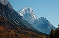
Monte Pelmo


cards
- Tobacco hiking maps (1: 25,000), sheets 03, 031 and 025
For the sake of completeness, further maps should be mentioned here, but they are not recommended due to their scale: The path is not always easy to find and sometimes sparsely marked, so that the hiker is dependent on orientation using exact maps.
- Compass hiking maps (1: 50,000), sheets 55, 57 and 77
- Freytag & Berndt hiking maps (1: 50,000), pages S10 and S15
- Carta d'Italia (1: 50.000), sheets “Dobbiaco”, “Cortina d'Ampezzo” and “Longarone”
- Tobacco hiking maps (1: 50,000), sheets 1 and 4
literature
- Franz Hauleitner: Dolomites. Höhenwege 1-3 (Rother hiking guide), Bergverlag Rother , Munich 2018 (14th edition).
- Andreas Dick: Il Giro Grande - adventurous hikes through the southeastern Dolomites , in: Dieter Kreutzkamp: Roads to Solitude. South Tyrol - Trentino. Between the Ortles and the Dolomites, between Brenner and Trento. On shepherds' paths and quiet mountain paths along the sunny side of the Alps , Munich: Frederking & Thaler Verlag, 1999, pp. 55–60.
- Eugen E. Hüsler : Death in the Dolomites. On a war climb through the "pale mountains" , in: Bergsteiger, Issue 12/2008, pp. 26–30 (on Monte Rite).
- Horst Höfler , Paul Werner: Via ferrata Dolomites with Vicentine Alps, Brenta and Lake Garda mountains. Bergverlag Rother, Munich 2000 (3rd, revised edition).
Web links
- Dolomiten Höhenweg 3. In: dolomiti.it. Retrieved August 16, 2020 .
- Italo Zandonella Callegher: Dolomitenhöhenweg No. 3. (PDF; 1.84 MB) Brochure with a description of the individual stages (deviating from the route described here). In: infodolomiti.it. 2005, archived from the original on April 1, 2012 ; accessed on August 16, 2020 .