Dürrensteinhütte
| Dürrensteinhütte | ||
|---|---|---|
|
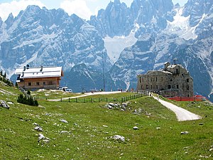
The Dürrensteinhütte to the left of the Plätzwiese plant |
||
| location | on the Plätzwiese ; South Tyrol , Italy | |
| Mountain range | Braies Dolomites | |
| Geographical location: | 46 ° 38 '30.8 " N , 12 ° 11' 45.1" E | |
| Altitude | 2040 m slm | |
|
|
||
| owner | Private | |
| Built | 1968-1970 | |
| Usual opening times | all year round | |
| accommodation | 28 beds, 0 camps | |
| Web link | Website of the Dürrensteinhütte | |
| Hut directory | ÖAV DAV | |
The Dürrensteinhütte ( Italian Rifugio Vallandro ) is a refuge in the Braies Dolomites .
Location and surroundings
The hut is located at an altitude of 2040 m in the area of the municipality of Braies in South Tyrol , Italy , in the Fanes-Senes-Braies Nature Park . It is located on the Plätzwiese high plateau , which separates the eastern branch of the Braies Valley from the Höhlenstein Valley .
The hut serves as a base for climbing tours and hikes in the surrounding mountains. To the north you reach the eponymous Dürrenstein , to the west the Hohe Gaisl . To the northwest you get to the eastern branch of the Braies Valley. The Landro can both south to Schluderbach as on the eastbound route north on Strudelkopf descend over.
history
At the end of the 19th century, the Plätzwiese plant was built in the immediate vicinity of today's hut , which was part of the Austrian fortifications on the border with Italy . In the years 1968–1970 Tristano Costantini from Niederdorf built the Dürrensteinhütte just a few meters east of the ruins that fell into disrepair after the First World War . In 2002 the hut was extensively renovated.
Web links
Individual evidence
- ↑ Hans Kammerer: Refuge huts in South Tyrol . Tappeiner, Lana 2008, ISBN 978-88-7073-422-5 , pp. 155 .
- ^ History. Dürrensteinhütte, accessed on October 11, 2015 .

