
Braies Dolomites
| Braies Dolomites | |
|---|---|
 Braies Dolomites in red on the Dolomites map |
|
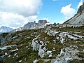
 View over the Sennesalm to the Seekofel |
|
| Highest peak | Hohe Gaisl ( 3148 m slm ) |
| location | South Tyrol and Belluno Province , Italy |
| part of | Dolomites |
| Classification according to | AVE 52k |
| Coordinates | 46 ° 40 ′ N , 12 ° 5 ′ E |
The Braies Dolomites are a mountain group of the Dolomites between the Pustertal in the north, the Höhlensteintal in the east and the Gadertal in the west. The southern border runs through the Enneberger or Rautal , which branches off from the Gadertal , continues at the head of the Rautal on the north side of the Camin group to Campo Croce and into the Valle del Boite to the Gemärkpass .
The Braies Dolomites are mainly divided by the Braies Valley , which branches off after a few kilometers to the Plätzwiese and the famous Braies Lake . Large parts belong to the Fanes-Senes-Braies Nature Park in South Tyrol , Italy .
The mostly steep north line , with an average height of 2500 m, hides the view from the Pustertal to the southern main range, which includes the higher peaks in a line from southeast to northwest. The mountains of the Braies Dolomites include:
- Hohe Gaisl ( 3146 m )
- Kleine Gaisl ( 2857 m )
- Dürrenstein ( 2839 m )
- Seekofel ( 2810 m )
- Muntejela de Senes ( 2787 m )
- Helltaler Bad ( 2711 m )
- Muntejela de Ciastlins ( 2673 m )
- Piz da Peres ( 2507 m )
- Dreifingerspitze ( 2479 m )
- Kronplatz ( 2275 m )
- Geierwand ( 2088 m )
photos
Pragser Dolomites from the Dreizinnenhütte seen from

Braies Dolomites and Hochalmhütte seen from the Lapedurscharte

Braies Dolomites near the Grünwaldalm in the valley of the same name


Individual evidence