
Dreizinnenhütte
| Dreizinnenhütte CAI hut category C |
||
|---|---|---|
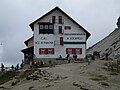
 Dreizinnenhütte with the Drei Zinnen in the background |
||
| location | at the foot of the Paternkofel , north of the Three Peaks ; South Tyrol , Italy ; Valley location: Sexten | |
| Mountain range | Sexten Dolomites | |
| Geographical location: | 46 ° 38 '13 " N , 12 ° 18' 38" E | |
| Altitude | 2405 m slm | |
|
||
| owner | CAI - Padua Section | |
| Built | 1935 | |
| Construction type | hut | |
| Usual opening times | Late June to late September | |
| accommodation | 40 beds, 100 camps | |
| Winter room | 0 bearings | |
| Web link | Dreizinnenhütte | |
| Hut directory | ÖAV DAV | |

The Dreizinnenhütte ( Italian Rifugio Antonio Locatelli - S. Innerkofler ) is a refuge of CAI in the Sesto Dolomites ( Dolomites , South Tyrol , Italy ) at an altitude of 2,405 slm m It is located at the foot of Paterno and offers the famous view of the Three Battlements . The hut is located in the area of the Dolomite War (1915–1918) , which is clearly visible in the area in the form of former war shelters, climbs and tunnels. The Dreizinnenhütte is the starting point for numerous hiking, via ferrata and climbing tours in the Drei Zinnen nature park and a popular destination for day-trippers.
Accesses

- Standard path from the Auronzo hut ( 2320 m , parking lot, public bus) via Lavaredohütte and Paternsattel, (path 101, walking time 1.5 hours, mountain bike route)
- From the Auronzo hut ( 2320 m ) via Forc. de Col de Mezo (path 105 or Dolomitenhöhenweg 4, walking time 2 hours)
- From Sexten via Fischleinboden (parking lot, public bus) to the Talschlusshütte (walking time 2 hours) and further through the Altensteintal (path 102, total walking time 4 hours)
- from the Höhlensteintal (car park, bus Toblach - Cortina d'Ampezzo ) through the Rienztal (path 102, walking time 3.5 hours)
- from Sextental (public bus) through the Innerfeldtal (parking lot) (path 105 or Dolomitenhöhenweg 4, walking time depends on the starting point)
Transitions
- Path 101 via Büllelejochhütte to Zsigmondyhütte
- via the Gamsscharte and the Schartenweg to the Büllelejochhütte ( via ferrata )
- via the Gamsscharte and Passportenscharte to the Paternsattel ( via ferrata )
Mountaineering
- Paternkofel ( 2744 m , former war tunnel and path, today Innerkofler climbing path)
- Toblinger knot ( 2617 m , ladder / via ferrata, refurbished war trails)
- Three Peaks
history
The first plans to build the first Dreizinnenhütte were made in 1881 by the Hochpustertal section of the German and Austrian Alpine Club . Since the construction was subsidized by the Central Committee of the Alpine Club, construction could soon begin, so that the hut was completed in September 1882. This first shelter, a small stone building with a kitchen with table and stove as well as beds on straw beds for a total of 18 people, was only inaugurated on August 25, 1883 due to storms. In 1886 and 1891 there were extensions and from 1892 the hut was also managed. An annual number of 642 visitors is known from 1897. In 1898 the alpinist and mountain guide Sepp Innerkofler took over the management of the hut. In 1907 the Dreizinnenhütte was extended by one floor, in 1908 the refuge, which now offers space for 55 mountaineers, was reopened. This year 2000 people have already visited the hut.
The hut was destroyed by Italian grenades during the mountain war in 1915. A nearby military barracks was used as a hut from 1920 to 1922, and a new hut was built in 1922 by the South Tyrol Alpine Association . In 1923 this hut was expropriated by the Italian state, handed over to the Club Alpino Italiano (CAI), Padua section and renamed Capanna Antonio Bettella . In 1935, the same section, in cooperation with the Bolzano section, built today's larger Dreizinnenhütte on the ruins of the old one. During the Second World War, the hut stood empty from 1942 to 1945, was looted and used as a sheepfold. In 1946 the Padua Section renovated the house after having also acquired the Bolzano Section's share and has been managing the hut ever since. Today the hut is visited by up to 2000 guests every day, mostly day visitors who hike here from the Auronzo hut .
Picture gallery

The Dreizinnenhütte seen from the south

Dreizinnenhütte with the Toblinger knot

Dreizinnenhütte seen from the fortifications from the First World War

map

Dreizinnenhütte around 1894
Dreizinnenhütte


literature
- Franz Hauleitner: Dolomites 5 - Sexten-Toblach-Braies . Bergverlag Rother , Munich, ISBN 3-7633-4199-4
- Peter Kübler, Hugo Reider: Fight for the Three Peaks . Publishing house Reider Touristik KG Sexten, ISBN 88-902466-0-X
- Tabacco topographical hiking map 1: 25,000, sheet 010, Sexten Dolomites
Web links
- Information about the hut, Italian / German
- Dreizinnenhütte in the historical Alpine archive of the Alpine associations in Germany, Austria and South Tyrol (temporarily offline)
Individual evidence
- ^ A b Hanspaul Menara : South Tyrolean refuges . 2nd Edition. Athesia, Bozen 1983, ISBN 88-7014-017-2 , p. 80-83, 162-163 .
- ^ A b Annemarie Maurer, Margareth Pallhuber, Ulrike Lanthaler: Nature parks in South Tyrol . Nature experience inside and outside. Ed .: Autonomous Province of Bozen-Südtirol Nature and Landscape Department. 2004, p. 18 ( bz.it [accessed January 12, 2014]).