
Büllelejochhütte
| Büllelejochhütte | ||
|---|---|---|
 Büllelejochhütte |
||
| location | below the Oberbachernspitze ; South Tyrol , Italy ; Valley location: Sexten | |
| Mountain range | Sexten Dolomites | |
| Geographical location: | 46 ° 37 '53.6 " N , 12 ° 20' 28.9" E | |
| Altitude | 2528 m slm | |
|
||
| owner | Private | |
| Built | 1965 | |
| Construction type | hut | |
| Usual opening times | Mid June to early October | |
| accommodation | 0 beds, 13 camps | |
| Winter room | No | |
| Web link | Büllelejochhütte | |
| Hut directory | ÖAV DAV | |

The Büllelejochhütte ( Italian Rifugio Pian di Cengia ) is a private refuge in the South Tyrolean part of the Sesto Dolomites in Italy . The name of the hut (Büllele) is derived from the word Bühel (hill). It is located at an altitude of 2528 m below the summit of the Oberbachernspitze 2675 m . The entire area is part of the Three Peaks Nature Park .
history
The hut was built in 1965, according to other information already in 1963, on the private initiative of Max Innerkofler, a grandson of the well-known mountain guide Sepp Innerkofler . In the vicinity of the hut there are still some residues from the war front during the First World War .
Entrances and transitions
Access to the hut is from the valley town of Moos ( 1339 m ) in the municipality of Sexten in the Sextental , a side valley of the Hochpustertal , through the relatively flat Fischlein valley via the Fischleinbodenhütte ( 1454 m ) to the Talschlusshütte ( 1526 m ) at the foot of the Einserkofels . The route can be shortened by using the hiking car park or the bus station at the Fischleinbodenhütte. A cycle path leads to the Talschlusshütte. There are two possible paths from the Talschlusshütte: On the one hand, the hut can be reached following the Bachertal via the Zsigmondyhütte ( 2224 m ) and further west over the Oberbachernjoch ( 2519 m ). On the other hand, you can walk through the Altensteiner Tal to the Dreizinnenhütte ( 2405 m ) and from there over the Büllelejoch ( 2522 m ). From the valley town of Innichen , access is from the hiking car park in Innerfeldtal, which can also be reached by bus, via the Dreischusterhütte ( 1626 m ) and further via the Dreizinnenhütte. The car park at the Auronzo hut ( 2320 m ) can be reached from Misurina via the toll road from the south . From here the path follows the road to the Lavaredohütte ( 2344 m ), further south around the Passportenkofel through the Cengia valley.
Mountaineering
The next peaks that can be reached from the hut are the western ( 2635 m ) and the middle summit ( 2675 m ) of the Oberbachernspitze, whereby only 100 and 150 meters in altitude have to be overcome. Nearby peaks that can be reached on day hikes are the Sandebühel ( 2607 m ), the Kanzel ( 2531 m ) and the Monte Cengia ( 2559 m ). A via ferrata can be walked from Oberbachernjoch to Sandebühejoch over the Cengia ridge with its highest peak at 2584 m . Demanding mountain tours can lead to the Hochbrunnerschneid ( 3046 m ) and the Schusterplatte ( 2957 m ) in three hours each.
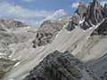
Picture gallery

Büllelejochhütte at the foot of the Oberbachernspitze
Büllelejoch - view from the Bodenalpe
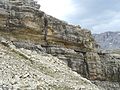
Old war trail at the Büllelejochhütte


literature
- Eugen E. Hüsler: hiking guide 5730 - Dolomites, Sexten, Hochpustertal . Compass maps, Rum / Innsbruck 2010, ISBN 978-3-85026-240-8 .
- Franz Hauleitner: Dolomites 5 - Sexten-Toblach-Braies . Bergverlag Rother, Munich, ISBN 3-7633-4199-4 .
- Compass hiking map 047 - Drei Zinnen / Tre Cime di Lavaredo . Compass maps, Rum / Innsbruck 2002, ISBN 978-3-85491-398-6 .
Web links
- official homepage
- Information about the hut (Italian, German, English)
- Hikes to and from the hut
Individual evidence
- ^ Hanspaul Menara : South Tyrolean refuges . 2nd Edition. Athesia, Bozen 1983, ISBN 88-7014-017-2 , p. 161 .
- ↑ Oberbachernjoch-Sandbüheljoch via ferrata