
Fischleintal
The Fischleintal ( Italian Val Fiscalina ) is a 4.5 km long side valley in the Sesto Dolomites in the easternmost part of South Tyrol in Italy, branching off from the Sesto Valley to the south .
location
It extends in full width from the Moos district of Sesto to the Talschlusshütte via Fischleinboden with the large car park of the same name and bus turning point for the Kreuzbergpass-Innichen / Toblach bus. The valley, which tapers towards the end of the valley, is easily accessible through paths, restaurants and accommodation providers. Behind the Fischleinboden, the asphalt road is replaced by unpaved but easily passable paths.
The valley is known nationwide for its scenic beauty and leads into the Drei Zinnen nature park , past some peaks of the Sexten sundial . Behind the Talschlusshütte (1,548 m), it forks at the foot of Einserkofel in the Bachern- and Altensteintal that against the Three Peaks and the First World War competitive Paterno go up. The Fischleintal is often hiked through on the approaches to the Dreizinnenhütte on the Toblinger Riedel and to the Zsigmondyhütte in the Bachern Valley.
The Fischlein valley drains via the Fischleinbach , which flows into the Sexten Bach , a tributary of the Drau , in the Sesto district of Moos .
history
The Fischleintal is documented as the high alp of the San Candido monastery since the 10th century under the name "Uiscalina" , which was later Germanized .
Landslide
On the morning of October 12, 2007, around 60,000 cubic meters of rock and debris fell from the Einserkofel (2,698 m) into the lower valley floor. No people were harmed, 30 vacationers were rescued unharmed. The rock fall buried large parts of a parking lot under rubble and caused the Fischleinbach to overflow its banks. The landslide is attributed to the explosive force of water freezing in crevices due to previous violent temperature fluctuations. An initially suspected consequence of global warming was put into perspective.
photos

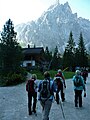
Fischleinboden hut
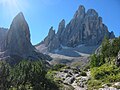
Hochleist (left) and Zwölferkofel the Sexten sundial
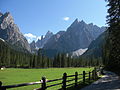
View from Fischleintal to the Sexten sundial.
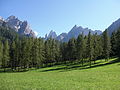
Larch meadows
Talschlusshütte at the end of the Fischleintal valley


References
- ^ Franz Huter : Innichen Abbey and the Settlement of Tyrol . In: Abbey and Monasteries. Development and importance in the cultural life of South Tyrol (yearbook of the South Tyrolean cultural institute). Bozen: Athesia 1962, p. 21ff.
- ↑ Martin Bitschnau , Hannes Obermair : Tiroler Urkundenbuch, II. Department: The documents on the history of the Inn, Eisack and Pustertal valleys. Volume 1: By the year 1140 . Universitätsverlag Wagner, Innsbruck 2009, ISBN 978-3-7030-0469-8 , p. 99-102, no. 134 .
- ^ Abendblatt.de Rockslide: Stone dust darkens Hochpustertal
- ^ Spiegel Online: Gigantic stone avalanche in the Dolomites
- ↑ Causes of the stone avalanche on the Einser on Swissalpin Wordpress
Web links
Coordinates: 46 ° 39 ′ 21 ″ N , 12 ° 21 ′ 11 ″ E