
Zsigmondyhütte
| Zsigmondy Hut Rifugio Zsigmondy – Comici |
||
|---|---|---|
 Zsigmondyhütte |
||
| location | at the foot of the Zwölferkofel ; South Tyrol , Italy ; Valley location: Sexten | |
| Mountain range | Sexten Dolomites | |
| Geographical location: | 46 ° 37 '42.4 " N , 12 ° 21' 29.9" E | |
| Altitude | 2224 m slm | |
|
||
| owner | Autonomous Province of Bolzano - South Tyrol | |
| Built | 1926 | |
| Construction type | hut | |
| Usual opening times | Mid-June to mid-September | |
| accommodation | 40 beds, 40 camps | |
| Web link | Zsigmondyhütte | |
| Hut directory | ÖAV DAV | |

The Zsigmondyhütte ( Italian Rifugio Zsigmondy Comici ) is a refuge in the Sesto Dolomites ( South Tyrol , Italy ). It is located on a rock ridge at the foot of the Zwölferkofel at an altitude of 2224 m . The surrounding area is part of the Drei Zinnen nature park . The hut was named after the famous Viennese alpinist Emil Zsigmondy . In 1948, the second name, Comici, was added after the Italian alpinist and mountain guide Emilio Comici (1901–1940) from Trieste.
history
The first hut was built by the Austrian Alpine Club (ÖAK) about 100 m from the current location in 1886 . After the hut, which was initially unmanaged, was damaged by an avalanche in the winter of 1887/1888, the building was soon restored. After the building had been enlarged, management began in 1902. Another significant extension to a larger house took place in 1908. This hut already offered accommodation for around 60 people. During the First World War , the hut was completely destroyed by Italian artillery on July 8, 1915 . A new building at the current location was only decided in 1926 by the Padua section of the CAI and completed in 1929. The hut, already similar in size to today's, has meanwhile been renamed Rifugio Benito Mussolini . During the Second World War , the house was looted again and badly damaged. The restoration took place in 1946 under the name Rifugio Comici . The hut was named Rifugio Zsigmondy-Comici in 1948.
Together with 24 other shelters expropriated by the state, the Zsigmondyhütte became the property of the Autonomous Province of Bolzano - South Tyrol in 1999; At the end of 2010, the license for their management by the CAI expired. Since 2015, the state of South Tyrol has been supported in the management of the hut (assignment to tenants, supervision of management, renovation measures) by a joint commission, in which the AVS and CAI are represented in addition to the public sector .
Accesses
The hut is accessed from the valley village of Moos ( 1339 m ) in the Sextener Tal, a side valley of the Hochpustertal , through the relatively flat Fischlein valley via the Fischleinbodenhütte ( 1454 m ) to the Talschlusshütte ( 1526 m ) at the foot of the Einserkofels . The route can be shortened by using the hiking car park or the bus station at the Fischleinbodenhütte. A cycle path leads to the Talschlusshütte. At the Talschlusshütte, starting with a somewhat steeper ascent (area of the Einserkofel landslide in October 2007), turn into the Bachern Valley, which runs between the Einserkofel and Elferkofel mountain ranges . The landmark of this section of the route is the striking peak of the Hochleist ( 2413 m ). The ascent to the hut takes you past the Kanzel and Hochleist, where the impressive Zwölferkofel massif soon becomes visible. The walking time from the Talschlusshütte must be planned for two hours.
Transitions
The hut can be used as a starting point to climb the famous alpine trail. At the end of this, you can descend to the Rotwandwiesenhütte with the nearby cable car to Sexten / Moos or via the Sentinellascharte to the Bertihütte . Transitions to other huts are the paths to the Büllelejochhütte ( 2528 m ) and on to the Dreizinnenhütte ( 2405 m ), southwest over the Zwölferscharte and the Rossleitn to the Lavaredohütte ( 2344 m ), and south-east over the Giralba-Scharte to the Carduccihütte ( 2297 m ).
Mountaineering
For alpine climbers, the Zwölferkofel is certainly the obvious destination. Demanding mountain tours can lead to the Hochbrunnerschneid ( 3046 m ) and the Oberbachern peaks ( 2675 m ). The summit of the Hochbrunnerschneid ( 3046 m ) can be reached starting from the Dolomiten-Höhenweg eastwards to the junction for the ascent via the Innere Loch. The path to the Oberbachern peaks leads over the Passo Fiscalino and the Büllelejochhütte. Hikes to the Hochleist ( 2413 m ) and the Kanzel ( 2531 m ) are ideal for shorter and easier tours .
Picture gallery
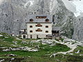
Zsigmondyhütte

Zsigmondyhütte

High performance 2413 m

Pulpit 2531 m


literature
- Compass hiking map 047 - Drei Zinnen / Tre Cime di Lavaredo. Compass maps, Rum / Innsbruck 2002, ISBN 978-3-85491-398-6
Web links
- Information about the hut (Italian, German)
- Zsigmondyhütte in the historical Alpine archive of the Alpine associations in Germany, Austria and South Tyrol (temporarily offline)
- Paths to and from the hut
Individual evidence
- ↑ Auf-Die-Berge.de: auf-die-berge.de Zsigmondyhütte
- ^ Hanspaul Menara : South Tyrolean refuges . 2nd Edition. Athesia, Bozen 1983, ISBN 88-7014-017-2 , p. 161 .
- ↑ Transition of the refuges: basis laid for leadership body. Autonomous Province of Bolzano - South Tyrol, press releases, October 2, 2009, accessed on January 30, 2012 .
- ↑ refuges. Autonomous Province of Bolzano - South Tyrol, Asset Management Department, accessed on January 30, 2012 .
- ^ Refuge: Agreement signed between Land, CAI and AVS. Autonomous Province of Bolzano - South Tyrol, press releases, July 8, 2015, accessed on July 8, 2015 .