
Bertihütte
| Bertihütte - Rifugio Berti al Popera CAI refuge category C |
||
|---|---|---|
 Bertihütte |
||
| location | Poperatal; Belluno Province in Veneto , Italy ; Valley location: Comelico Superiore | |
| Mountain range | Sexten Dolomites | |
| Geographical location: | 46 ° 37 ′ 51.4 " N , 12 ° 24 ′ 21" E | |
| Altitude | 1950 m slm | |
|
||
| owner | CAI - Padua Section | |
| Built | 1962 | |
| Construction type | Refuge | |
| Usual opening times | Mid June to late September | |
| accommodation | 0 beds, 48 camps | |
| Winter room | yes (8) | |
| Web link | www.rifugioberti.it | |

The Berti Hut (Italian name: Rifugio Berti al Popera ) is a refuge of CAI in the Sesto Dolomites . It is located at an altitude of 1950 m at the lower end of the Popera Valley on the ridge of the Creston Popera, which belongs to the mountain range of the Popera Dolomites. The hut belongs to the Comelico Superiore municipality in the province of Belluno , Italy .
history
The Bertihütte was built in 1962 and rebuilt in 1984. It was named after the doctor and mountaineer Antonio Berti (January 17, 1882 - December 8, 1956). Antonio Berti played a key role in the development of the eastern Dolomites, where he carried out over 100 first ascents and first ascents.
Entrances and transitions
The easiest access is via the road that branches off the Carnic Dolomite Road at Valgrande , through the Risenatal to the Lunellihütte ( 1568 m ), where there is a parking lot for hikers. From there, the ascent to the Bertihütte can be mastered in an hour. Alternatively, the Bertihütte can be reached from the Kreuzbergpass eastwards past the Arzalpenkopf ( 2371 m ) via the Pian della Biscia-Sattel ( 1942 m ) in 2.5 hours. Starting from the Bertihütte, you can first climb to the Sentinellascharte ( 2717 m ). From there, the Zsigmondyhütte ( 2224 m ) can be reached via the Alpinisteig, the Talschlusshütte ( 1526 m ) via the Anderter Alm and the Rotwandwiesenhütte ( 1924 m ) via the Rotwandwiesen. The transition to the Carduccihütte ( 2297 m ) is via the via ferratas Aldo Roghal and Gabriella, between which the Cadore bivouac ( 2219 m ) is located.
Mountaineering
A worthwhile goal is to climb the Sesto Rotwand ( 2965 m ) via its south side. To do this, you first climb the Poperatal from the Bertihütte until the Zandonella via ferrata branches off towards the summit shortly before the Sentinellascharte. The summit cross of the Sesto Rotwand is at a height of 2,936 m. The main summit and highest point is the Vinatzerturm (2965 m). The descent can be made via the Anderter Scharte ( 2698 m ) to the Burgstall. From there you can continue to the Rotwandwiesen, from where a gondola lift leads into the valley to Sexten / Moos, or facing east over the Arzalpensattel or Pian della Biscia-Scharte to the Bertihütte. A simple tour can lead to the Arzalpenkopf ( 2371 m ), also known as the eight summit of the Sexten sundial . The ascent first takes place on the ridge of the Creston Popera to the former Sala hut. From there the path continues towards the Arzalpensattel, where shortly before the path to the summit branches off. The way back is the same or via the Arzalpensattel.
Picture gallery

Berthütte on the Creston Popera ridge

Berthütte between Sesto Rotwand and Neuner in the background
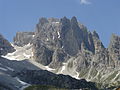
Sesto Rotwand (south side) with Poperatal and Sentinellascharte (left)

Sala hut


literature
- Eugen E. Hüsler: hiking guide 5730 - Dolomites, Sexten, Hochpustertal, Kompass-Karten GmbH, Rum / Innsbruck 2010, ISBN 978-3-85026-240-8
- Franz Hauleitner: Dolomites 5 - Sexten-Toblach-Prags , Bergverlag Rother Munich, ISBN 3-7633-4199-4
- Kompass hiking map 047 - Drei Zinnen / Tre Cime di Lavaredo, Kompass-Karten GmbH, Rum / Innsbruck 2002, ISBN 978-3-85491-398-6