
Cadini group
| Cadini group | |
|---|---|
 The north side of the Cadini group |
|
| Highest peak | Cima Cadin di San Lucano ( 2839 m slm ) |
| location | Belluno Province , Italy |
| part of | Dolomites |
| Coordinates | 46 ° 35 ′ N , 12 ° 17 ′ E |
The Cadini di Misurina form the southern end of the Sexten Dolomites as a subgroup and are located in the province of Belluno in Italy . The mountain landscape, which is very impressive due to its numerous spectacular rock peaks and battlements, is bordered by Lake Misurina in the west , the Three Peaks in the north and the Ansieital in the south and east and is considered a paradise for climbers. The highest mountain is the Cima Cadin di San Lucano (2839 m).
A very exposed via ferrata , the Via Ferrata Merlone , leads to the Cima Cadin Nord Est (2796 m) . The Bonacossaweg ( Sentiero Bonacossa ) crosses, partly exposed and insured, using rock bands and old paths from the mountain war , over several notches across the entire mountain range. The high alpine circuit of the central Cadini group ( Giro di Cadini ) on the Sentiero Durissini is also a worthwhile tour . In winter, this path is considered a very demanding ski tour .
A chairlift leads from Lake Misurina to the Rifugio Col de Varda.
More striking peaks
- Cima Cadin di Rimbianco (2404 m)
- Cima Eötvös (2837 m), named after Roland von Eötvös
Mountain huts in the Cadini group
- Fonda Savio Hut (2359 m, CAI )
- Rifugio Città di Carpi (2110 m, CAI)
- Rifugio Col de Varda (2106 m, private)
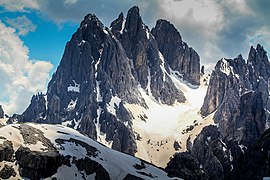
Cima Cadin Nord Est, Cima Cadin di San Lucano and Cima Eötvös

Bonacossaweg

The Cadini group from Lake d'Antorno
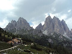
Rifugio Città di Carpi


.jpg)

Web links
- Giro dei Cadini on summitpost.org (English)