
Pordoi Pass
| Pordoi Pass | |||
|---|---|---|---|
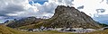
 Pass road heading west (the Langkofel group in the background on the left) |
|||
| Compass direction | west | east | |
| Pass height | 2239 m slm | ||
| Fassa Valley ( Trentino ) | Buchenstein Valley ( Belluno ) | ||
| Watershed | Avisio → Etsch | Cordevole → Piave | |
| Valley locations | Canazei | Arabba | |
| expansion |
|
||
| Built | 1905 | ||
| Mountains | Dolomites | ||
| Map (Trentino) | |||
|
|||
| Coordinates | 46 ° 29 '15 " N , 11 ° 48' 45" E | ||

The Pordoijoch (ital. Pordoi ; fassanisch- Ladin Jouf de Pordoi , buchensteinisch-Ladin Jou de Pordou ) is provided with a crest height of 2239 m slm the second highest provided with a continuous asphalt road mountain pass in the Dolomite Italy. It connects Canazei in the Fassa Valley (Italian: Val di Fassa , Fassan-Ladin Fascia ), province of Trentino with the valley of Buchenstein (district Arabba ) / Veneto .
location
The Pordoi Pass is surrounded by the 3181 m high Langkofel (in the northwest), the plateau rocks Sass Pordoi ( 2950 m ), Sass de Forca ( 2917 m ) and the highest rock peak Piz Boè ( 3152 m ) in the north, as well as in the Sella massif south from the western foothills of the Marmolatagruppe counting Padonkamms to the Belvedere ( 2650 m ) and Porta Vescovo ( 2562 m belong). This Vorkamm obscured the view of the Marmolada , which can be seen only from the crest height of.
The Cordevole river rises south-east of the Pordoi Pass on the Venetian side. It flows through the Buchenstein Valley and flows into the Piave 70 kilometers further south ; it is the largest right tributary of the Piave. The view to the east extends over Arabba to the Fanes group and Le Tofane .
history
The history of the Pordoi Pass begins with the construction of the Great Dolomite Road , which began in this section in 1901 and was completed in 1905. The Hotel Savoia and the Hotel Pordoi , some of which still have the original Art Nouveau frescoes, were the first hotels on the pass. Before that, there had been an accommodation hut of the DuÖAV section Merano since 1902 , built and managed by Maria Dezulian, a sister of the mountaineering legend Tita Piaz .
This first phase of the development of tourism, to which a memorial stone with the technical data of the Great Dolomite Road commemorates, was interrupted by the First World War, when the area east of the Pordoi Pass became a battle zone. At Arabba the front line of the Austrians ran against Italy; The Italians blew up the Col di Lana on the night of April 17-18, 1916 , which the Austrians then had to give up as a defensive position. However, there was no Italian breakthrough.
A memorial with a military cemetery , where 8,582 Austrian and German soldiers from the First and 847 from the Second World War are buried, is within walking distance of the pass .
In the 1950s, the region experienced a new economic boom after the Second World War , which, in contrast to the First World War, did not cause any major damage on the Pordoi Pass. In 1962 Maria Dezulian, called “Mare del Pordoi”, built the cable car to Sass Pordoi together with her son Francesco , one of the first in the Dolomites and without an intermediate support between the valley and mountain stations. This was followed by the construction of additional lifts, hiking trails and via ferratas in the Sella. The hotels, which were occupied by German Wehrmacht air intelligence troops and Italian security guards during the war, were reopened, and additional accommodations, restaurants and souvenir shops were added. In summer, dealers from the region also set up their stalls in the parking lots along the pass road. The Pordoi Pass is the highest on the Dolomite Road and offers a breathtaking panorama of the Dolomites, especially with its wide field of vision to the east.

Trentino side with Langkofel

View of the Sella group

View of the Pordoi Pass
Panorama from the top of the pass and descent towards Buchensteintal


Tourist infrastructure and sports
The Pordoi Pass, together with the Passo Sella , the Passo Gardena and the Campolongo Saddle, form the four-pass trip around the Sellastock .
Easy hiking trails lead to Canazei and Arabba. The Dolomites high path no. 2 leads through the Pordoi Pass to Sass Pordoi and on to Piz Boè . The cable car, which overcomes the 700 meters in altitude to Sass Pordoi in four minutes, shortens this ascent considerably. On the fore ridges of the Marmolada you can climb the so-called Bindelweg ; On this panoramic path along the historical trade route from Trentino to Veneto you can see the Marmolada, the Fassa Valley and Lake Fedaia . It is counted among the most beautiful in the Dolomites.
In winter, the Pordoijoch is also an alternative to the Belvedere as part of the Sellaronda with a piste connection to the Lupo Bianco / Belvedere ski area. It is part of the national ski area Dolomiti Superski . For experienced skiers, the Sass Pordoi is the starting point for a descent through the Pordoi-Scharte, back to the pass and a high-alpine ski tour through the Mittagstal (Val Mesdì), which opens north from the Sella high plateau .
Other ski runs with several lifts run on the Trentino side in the Col di Ross area (and on the Venetian side in the direction of Arabba).
Giro d'Italia
The Pordoi Pass was a stage destination of the Giro d'Italia several times :
- June 6, 1990 : 16th stage; The winner was the Frenchman Charly Mottet ;
- June 12, 1991 : 17th stage, won by Franco Chioccioli ;
- June 7, 1996 : 20th stage, won by Enrico Zaina ;
- June 1, 2001 : 13th stage, won by the Mexican Julio Pérez Cuapio .
On the Pordoi pass there is also a monument to the five-time Giro winner Fausto Coppi (1919–1960).

Web links
Individual evidence
Agnello • Aprica • Assietta • Aurine • Borcola • Bordala • Brennero / Brenner • Brocon • Cadibona • Campo Carlo Magno • Campolongo • Camporosso (Saifnitzer) • Carnizza • Castrin / Hofmahd • Cereda • Ciampigotto • Cibiana • Cimabanche • Coe • Colombardo • Croce d'Aune • Croce Domini • Crocette • Costalunga / Karer • Duran • Eira • Eores / Kofel • Esischie • Erbe / Würz • Falzarego • Fauniera • Fedaia • Finero • Finestre • Foppa • Foscagno • Furcia / Furkel • Fusine (Ratschacher ) • Gavia • Gardena / Grödner • Giau • Gola / Klamml • Gran San Bernardo • Kreit • Lavazè • Livigno • Lombarda • Lúsia • Lys • Maddalena • Manghen • Mauria • Mendola / Mendel • Mont Rest • Monte Croce / Plöcken • Monte Croce di Comélico / Kreuzberg • Monte Giovo / Jaufen • Mortirolo • Nevea • Nigra / Niger • Palade / Gampen • Pampeago / Pale / Reiter • Pénnes / Penser • Pian delle Fugazze • Piccolo San Bernardo • Pordoi • Pramollo (Nassfeld) • Predil • Resia / Reschen • Rolle • Russis • Rombo / Timmel • Sampeyre • San Antonio • San Boldo • San Giovanni • San Lugano • San Marco • San Pellegrino • Santa Maria (Umbrail) • Sella • Sestriere • Sommo • Spluga (Splügen) • Stalle / Staller • Staulanza • Stelvio / Stilfser • Tanamea • Tenda • Tonale • Tre Croci • Tremalzo • Valles • Valcavera • Valparola • Vezzena • Vivione • Zovo