Hofmahdjoch
| Hofmahdjoch Passo Castrin |
|||
|---|---|---|---|
|
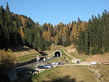
The Hofmahdjoch as seen from St. Pankraz in Ulten, towering above the Laugen on the left and the small and large Kornigl on the right |
|||
| Compass direction | North | south | |
| Pass height | 1781 m slm | ||
| province | Trent | ||
| Watershed | Marauner Bach, Falschauer | Pescara, Noce | |
| Valley locations | St. Pankraz | Proveis | |
| expansion | Footpath, road with pass tunnel | ||
| Built | 1998 | ||
| Mountains |
Ortler Alps (west) Nonsberg group (east) |
||
| map | |||
|
|
|||
| Coordinates | 46 ° 30 '53 " N , 11 ° 3' 5" E | ||
The 1781 m high Hofmahdjoch , or Hofmahd for short ( Passo Castrin in Italian ), is a mountain pass in Italy that connects the South Tyrolean Ulten Valley with the Non Valley and separates the Ortler Alps from the Nonsberg Group. While the pass ramps mostly belong to South Tyrol, the top of the pass is located in the Trentino area. This is accessed by an easy-to-walk hiking trail. The modern road crosses under the pass in an approximately 1,600 meter long tunnel, the portals of which are on both sides of South Tyrol. In the west the Hofmahdjoch is dominated by the Kleiner Kornigl , in the northeast by the Laugen .
geology
The Periadriatic Seam runs over the Hofmahdjoch and represents the border between the Central Eastern Alps and the Southern Alps . Contrary to the prevailing trend, the seam here runs approximately NNE – SSW. The Nonsberg group to the east of the Hofmahdjoch belongs to the Southern Alps, the Ortler Alps to the west to the Eastern Alps.
history
In 1984, G. Niederwanger found pieces of mesolithic stone tools on the broad-soled alpine meadow saddle of the Hofmahdjoch . Later, others also found more recent ceramic fragments.
For the late Middle Ages around 1434 it is reported that the communities around Proveis were settled from the Ulten valley via the Hofmahdjoch. The Ultental itself is said to have been originally settled by Goths before the Bavarians invaded in the early Middle Ages . Probably during the migration period some Ostrogoths withdrew to the remote Ulten Valley and made it arable. Numerous place and field names, but also family names, can be traced back to their settlement, which one tries to prove not least by found rune inscriptions .
Proveis and Laurein on Deutschnonsberg formed decades traffic technically a South Tyrolean exclave in Trentino , as they for the road transport were accessible only by detours through Trentino territory. From the beginning of the 1990s, a road with a tunnel was built under the top of the pass to connect the two Deutschnonsberg communities with the Ultental and thus create a connection to the South Tyrolean transport network. On December 1, 1998, the new pass road was finally opened.
Web links
swell
- ^ Steffan Bruns: Alpine passes . The passes on both sides of the Brenner route. tape 1 . L. Staackmann Verlag KG, Munich 2010, ISBN 978-3-88675-256-0 , p. 90 .
- ^ AL: Blessing of the Hofmahdstrasse Ulten - Proveis . In: Community of St. Pankraz (Ed.): Communications of the community of St. Pankraz . No. 5 . St. Pankraz December 2007, p. 16-17 ( riskommunal.net [PDF; accessed March 2, 2008]).


