Lye tip
| Lye tip | ||
|---|---|---|
|
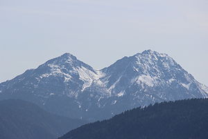
on the right the Große Laugen from the northwest, on the left the Kleine Laugen |
||
| height | 2434 m slm | |
| location | South Tyrol , Italy | |
| Mountains | Nonsberg group | |
| Dominance | 5.5 km → Schöngrubspitze | |
| Notch height | 653 m ↓ Hofmahdjoch | |
| Coordinates | 46 ° 32 '5 " N , 11 ° 5' 9" E | |
|
|
||
| rock | porphyry | |
| particularities | First known women's ascent in history, summit library | |
|
View from the Laugenspitze to the east |
||
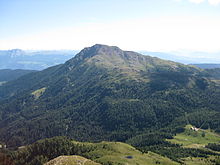
The Laugenspitze ( Italian Monte Luco or Monte Lucco ) is at 2434 m slm the highest mountain in the Nonsberg group in South Tyrol . Their distinctive twin peaks consists of the Great bases and small bases .
Location and surroundings
The Laugenspitze is located between the Deutschnonsberg and Ulten in the north of the Nonsberg group, southwest of the Etschtal . Due to its close proximity to the Ortler Alps , southwest of the 1785 m high Hofmahdjoch , it is sometimes dealt with in alpine literature as part of this mountain range.
In the west lies the Marauntal, a side valley of the Ulten valley. , Located in the northeast of the Great alkalis ( Monte Luco Grande ) through the small Laugensee ( Lago di Luco separately), the 2297 m high Small alkalis ( Monte Luco Piccolo , 46 ° 32 ' N , 11 ° 6' O ). To the east is the 1518 m high Gampenpass , which joins the Our Dear Lady in Walde-St. Felix ( Senale-San Felice ) connects with the Adige Valley. The border with Trentino runs only about 500 m southwest of the summit .
On the slopes of Laugenspitze several pastures , such as the Laugenalm ( 1853 m ) to the southeast, the Upper Walschalm ( Malga Pradont , 1,905 m ) to the southwest and the Laugneralm ( 1748 m ) to the west.
geology
The two caustic peaks are the remains of a volcano that was formed over 250 million years ago and is related to the Etschtal volcanic group . The lye tip is largely made up of porphyry . The geomorphology of the mountain clearly shows glacial forms such as rock ridges polished smooth by the Ice Age glaciers.
Alpinism
The Laugenspitze is accessible via several marked hiking trails. The easiest of these paths leads over the gentle south ridge, it can be reached from Mitterbad in the Marauntal, from the Hofmahdjoch or from the Gampenpass. Somewhat steeper, but more popular, is the path over the rocky southeast ridge, which is accessible from the Gampenpass or from Platzers, a fraction of Tesimo . This ascent can also be done as a ski tour in spring . Another path leads from the north (Buchen in the Marauntal) and finally over the northeast ridge to the summit.
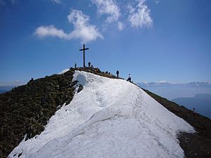
The Laugenspitze is a popular panoramic mountain, offering an impressive panorama of the Texel Group in the north and the Ortler Alps in the west. The Dolomites as well as the Brenta and Presanella groups can also be seen from here.
history

Due to its exposed location, the Laugenspitze is particularly prone to thunderstorms, which is also expressed in numerous legends . It was considered the seat of weather witches by the local population .
The first known ascent of the Laugenspitze was made on August 24, 1552 by the local noblemen Jakob von Boymont zu Payrsberg, Regina von Brandis and their daughter Katharina Botsch. This is considered to be one of the first ever documented ascent of a mountain, but in particular the first known ascent of women in the history of alpinism .
In 1901 Thomas Mann climbed the Laugenspitze on the occasion of his spa stay in Mitterbad / Ultental and left the following poem: “… We often climbed the mountains - for the benefit of our lungs. We climbed the Laugenspitze there - with the Doctor von Hartungen ... "
In 2007, the South Tyrol Laugen summit library - an Alpine bookcrossing project - was initiated on the Laugenspitze .
Web links
Individual evidence
- ^ Peter Höll: Alpine Club Guide Ortleralpen . Ed .: German Alpine Club , Austrian Alpine Club and Alpine Club South Tyrol . 9th edition. Bergverlag Rother, Munich 2003, ISBN 978-3-7633-1313-6 , p. 451 ( Google Books ).
- ↑ a b c Kompass Karten (Ed.): Digital map of South Tyrol / Alto Adige . Rum 2007, ISBN 978-3-85491-631-4 .
- ↑ a b c Gerhard Hirtlreiter: South Tyrol West: Vinschgau, Meran, Kalterer See: 52 tours between Stilfser Joch and Sterzing, Schnals and Salurn . Bergverlag Rother, 2006, ISBN 978-3-7633-3025-6 , p. 194 ( Google Books ).
- ↑ a b c d Laugen ( Page no longer available , search in web archives ) Info: The link was automatically marked as defective. Please check the link according to the instructions and then remove this notice. , Hanspaul Menara on meranerland.com, accessed May 12, 2011
- ↑ Heinrich Gruber, Hans Pescoller, Rudolf Weiss: Alpine Association Skitourenführer Eastern Alps . South Tyrol West. tape 7 . Bergverlag Rother, Munich 1989, ISBN 978-3-7633-5229-6 , p. 237 ( Google Books ).
- ^ Adolf Schaubach : The German Alps for locals u. Friends portrayed . Central and southern Tyrol. 2nd Edition. tape 4 , 1867, p. 152 ( Google Books ).
- ↑ Hanspaul Menara , Hannsjörg Hager: Mountains and mountaineers: Alpine history of South Tyrol . Athesia, 1994, ISBN 978-88-7014-809-1 , pp. 191 .


