Nxai Pan National Park
|
Nxai Pan National Park
|
|
|
Salt pan in Nxai Pan National Park |
|
| location | Botswana |
| surface | 2578 km² |
| WDPA ID | 601 |
| Geographical location | 20 ° 3 ′ S , 24 ° 46 ′ E |
| Setup date | 1992 |
| administration | Department of Wildlife and National Parks |

The Nxai Pan National Park (English: Nxai Pan National Park ) is located north of the Makgadikgadi Pans National Park in Botswana . It is named after a hook-shaped metal rod Nxai, which was used to dig spring hares out of their underground passages.
location
The national park is located in the North West District of Botswana, 136 kilometers from Maun in the direction of Nata north of the Makgadikgadi Pans National Park and is only separated from it by the paved Maun – Nata highway (A3).
history
The area of the national park belonged to the settlement area of the San . From 1950 to 1963 the so-called "old trek" led through the park. This route was used by the farmers to drive the herds of cattle through the Ngamiland to Kazungula on the Zambezi . However, the veterinary control fences erected to combat foot and mouth disease interrupted this route. In 1970 an area of 1676 square kilometers around the Nxai Pan was declared a game reserve and in 1992 the area around the Kudiakam Pan was enlarged to 2578 square kilometers and made a national park.
landscape
In the south of the national park between the asphalt road and the park entrance lies the Kudiakam Pan, in the north of the park the Nxai Pan and in the northeast the Kgama Pan. The salt pans belong to the Makgadikgadi salt pans system and are the remains of a large lake. In years with heavy rainfall, the salt pans can refill with water. The national park is located on the northeastern edge of the Kalahari at an altitude of 900 meters above sea level.
vegetation
Outside the salt pans, the national park is characterized by grasslands of a typical dry savannah and mopane forest, some collections of umbrella acacias and baobabs .
Probably the best-known collection of baobabs are the Baines baobabs east of the Kudiakam salt pan. They are named after Thomas Baines , a British painter and explorer who visited and painted this group of baobabs on December 29, 1861.
Wildlife
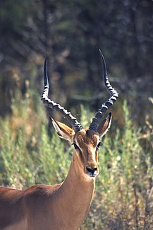
The national park is on the herd migration route between the Okavango Delta and Hwange National Park in Zimbabwe or the grasslands in and around Makgadikgadi Pans National Park to the south. Permanent can lions , bat-eared foxes , black-backed jackal , giraffe , kudu , impala and springbok encounter. In addition to ostriches , the national park has a large variety of birds. In the rainy season, the park fills up with billy goats , elephants and thousands of zebras .
Infrastructure / tourism
As in most of Botswana's national parks, the infrastructure for tourism in the national park is not very well developed. Those who are not self-catering with a tent or camper can only visit the national park with organized tours. The park is open all year round.
Park entrance
The approach to the park entrance branches off the asphalt road Maun – Nata to the north after 136 kilometers from Maun and 65 kilometers before Gweta . After 37 kilometers of sandy slopes, you reach the Nxai salt pan with the park entrance in front of it.
Streets
There are no paved roads in the park. Most of the slopes, especially the access from the asphalt road, are only suitable for off-road vehicles . After heavy rainfall, the slopes are hardly passable.
accommodation
In the entire national park there are no paved accommodations and only two, as in all national parks in Botswana, non-fenced campsites with rudimentary sanitary facilities. You can also spend the night at the Baines baobabs by registering with the park rangers.
care
There are no restaurants or supply options in the national park, nor are there any petrol stations. The nearest gas station is in Gweta, 65 kilometers away from the junction of the asphalt road.
Web links
Description at botswanatourism.co.bw (English)


