Furkelpass
| Furkelpass | |||
|---|---|---|---|
|
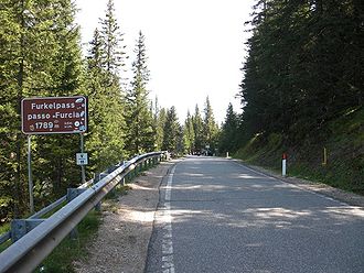
Pass height with information sign |
|||
| Compass direction | Northeast | southwest | |
| Pass height | 1789 m slm | ||
| province | Bolzano (Region Trentino-South Tyrol ) | ||
| Valley locations | Olang ( Val Pusteria ) | St. Vigil ( Vigil Valley , Gadertal ) | |
| expansion | Strada Provinciale 43 | ||
| Winter closure | No | ||
| Mountains | Dolomites | ||
| profile | |||
| Ø pitch | 8.1% (? M / 9.1 km) | 6.1% (? M / 12.3 km) | |
| Max. Incline | 12% | 11.4% | |
| map | |||
|
|
|||
| Coordinates | 46 ° 43 '22 " N , 11 ° 58' 7" E | ||
The Furkelpass , also called Furkelsattel or simply the Furkel ( Ladin Ju de Furćia , Italian Passo Furcia ), is a 1789 m high mountain pass in the Dolomites . The pass lies between the 2275 m high Kronplatz in the north and the 2507 m high Piz da Peres in the south and connects the villages of Olang in the Puster Valley and St. Vigil in Enneberg in the Italian province of South Tyrol . The pass thus also marks the historical language border between German and Ladin-speaking areas in the Dolomites.
The pass road is 19 kilometers long and overcomes an altitude difference of 744 meters. The average gradient is 12%, the maximum gradient 15%. A stage of the "Giro d'Italia" (1981, 1994, 1997, 2004, 2006, 2008, 2010), as well as the "Transalp" (crossing the Alps by bike) have already led across the road several times. Some cyclists also tackle the climb to the Kronplatz via the Furkelpass.
The pass is open in winter. Since it crosses the Kronplatz ski area, skiers are guided over the pass road with a bridge. From the pass there is a direct connection to Plan de Corones and St. Vigil.
Since 2003 there has also been an artificially created lake at the top of the pass, which is required for artificial snow.
Individual evidence
- ↑ Incline to Kronplatz ( page no longer available , search in web archives ) Info: The link was automatically marked as defective. Please check the link according to the instructions and then remove this notice.

