Gardena Pass
| Gardena Pass | |||
|---|---|---|---|
|
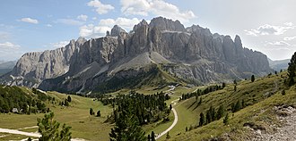
View of the Gardena Pass with the Sella group from the Cir peaks |
|||
| Compass direction | west | east | |
| Pass height | 2121 m slm | ||
| province |
|
||
| Watershed | Gardena stream → Eisack | Gader → Rienz → Eisack | |
| Valley locations | Selva ( Val Gardena ) | Corvara ( Val Badia ) | |
| expansion |
|
||
| Built | 1915 | ||
| Mountains | Dolomites | ||
| map | |||
|
|
|||
| Coordinates | 46 ° 33 '0 " N , 11 ° 48' 34" E | ||
The Gardena Pass ( Val Gardena- Ladin Ju de Frara , Val Gardena-Ladin Jëuf de Frea ; Italian Passo Gardena ) is a 2121 m high mountain pass in the South Tyrolean Dolomites . It connects Val Gardena with the Val Badia and the communities of Selva and Corvara .
location
The Grödner Joch is a saddle between the Sella Group in the south and the Cir peaks , which form the gateway to the Puez-Geisler Nature Park , in the north. To the west, the sight of the 3181 m high Langkofel with its characteristic elongated south wall, which gave the massif its name, is “impressive” ; to the east, the view to the mountain tops of the open Val Badia ( Sass Songher , the Fanes with Heiligkreuzkofel , Piz Cunturines and Piz Lavarela ) and the further east located Tofanagipfel .
On the Gardena side, the Ruf de Frea rises below the pass, a tributary of the Gardena stream . On the side of the Gader valley, various streams of the Sella and Cir groups arise, which unite to form the Gader .
history
The Stone Age finds - charred remains of wood, animal bones and flint tools - are among the oldest in the Sella area. A Mesolithic settlement horizon could be made out a little below the yoke at the Abri Plan de Frea . Little is known about the settlement, just as little is known about the use of the transition in antiquity, in the Middle Ages and in the early modern period. However, in a are traditional note of the Bishopric of Freising from the last quarter of the 11th century, the alpine meadows on Plan de Frea ( "Planum" () and the yoke itself "jugum eiusdem montis" ) explicitly mentioned.
The Grödner Joch was hardly included in the beginnings of tourism in the Dolomites, as there was no road yet. Franz Moroder , mayor of Ortisei, tried in 1895/96 to create the first Gardena Joch hospice, which was built by the Bozen section of the German and Austrian Alpine Association .
A driveway was only laid out during the First World War in 1915 for the purpose of supplying the front and supplying the troops. The German-Austrian front was at Arabba in Buchensteintal (defense position Col di Lana ), the connecting route ran from Bozen through Val Gardena with a narrow-gauge railway to Plan (reloading station). From here we continued with a cable car over the Gardena Pass to Corvara and then over the Campolongo Pass or alternatively over the Sellajoch and Pordoi Pass to the front.
On May 5, 1920, the Passo Gardena was the meeting point of representatives of the five Ladin valleys of Tyrol, who protested against the denial of the right to self-determination and demanded recognition as a separate ethnic group.
The Gardena Pass only gained importance for tourist purposes around the middle of the 20th century. An asphalt road next to the old Jochfahrweg has only existed since 1960. A branching network of hiking trails and ski slopes and lifts were built on both sides of the pass. In addition to the historic hospice, additional accommodations and shops were built.
Tourist infrastructure / sport
With the Sella Pass , the Pordoi Pass and the Campolongo Pass , the Gardena Pass forms the four-pass Sella Ronda tour around the Sella for cyclists ; in winter, this round can be tackled with a combination of lifts and downhill runs on skis.
Hiking trails lead down to Corvara and Selva either over the Plan de Frea or through the Dantercepies valley below the lift. These slopes are ski areas in winter.
The Dolomites high path No. 2 leads into the Sella , partly designed as a via ferrata . A popular route for experienced climbers is the Pisciadù-Steig ( Via ferrata Brigata Tridentina ) with a suspension bridge at the Exnerturm.
The Dolomites high path No. 2 continues through the Cir peaks on the north side of the Gardena Pass and leads to the Crespeina plateau with the Crespeina lake and further into the Puez group.
hiking map
- Grödnertal / Val Gardena , 1: 25,000, mapgraphic Bozen
Web links
Individual evidence
- ↑ Martin Bitschnau , Hannes Obermair : Tiroler Urkundenbuch, II. Department: The documents on the history of the Inn, Eisack and Pustertal valleys. Volume 1: By the year 1140 . Universitätsverlag Wagner, Innsbruck 2009, ISBN 978-3-7030-0469-8 , p. 222, no. 250 .


