
Gavia Pass
| Passo di Gavia / Gavia Pass | |||
|---|---|---|---|
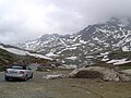
 South ramp of the Gavia Pass |
|||
| Compass direction | North | south | |
| Pass height | 2621 m slm | ||
|
|
|
|
|
| Watershed | Frodolfo → Adda → Po | Oglio → Po | |
| Valley locations | Bormio | Ponte di Legno | |
| expansion | Strada provinciale 29 del Passo di Gavia |
||
| Mountains |
Sobretta-Gavia group (west) Ortler group (east) |
||
| particularities | South ramp very narrow in places | ||
| profile | |||
| Ø pitch | 5.6% (1393 m / 24.8 km) | 7.7% (1360 m / 17.6 km) | |
| map | |||
|
|||
| Coordinates | 46 ° 20 '37 " N , 10 ° 29' 17" E | ||
.png)
The Gaviapass ( Italian Passo di Gavia ) is a mountain pass in the Italian Alps . It connects the provinces of Sondrio in the north with Brescia in the south and separates the Sobretta-Gavia group in the west from the Ortler group in the east.
location
The mountain pass is located in the Stilfserjoch National Park and connects Bormio in the north with Ponte di Legno in the south via a 43 km long pass road. On the north ramp, ten hairpin bends have to be negotiated up to the pass height at 2621 m slm , on the south ramp 15 hairpin bends. The height difference to be overcome is about 1400 m.
The pass is relatively good and has two lanes on its north ramp. On the other hand, the south ramp, which has only been asphalted since the late 1990s, has a few very narrow hairpin bends and a roadway that is only 1.9 to 3 meters wide in places. There are a few passing points for oncoming traffic. On the south side there is also an approx. 800 m long tunnel that serves as a bypass for a very narrow section that has meanwhile been closed to traffic. On busy days, difficult traffic situations can arise, especially on the south ramp, as it is impossible for two vehicles to pass through on some sections.
The top of the pass lies between the Monte Gavia ( 3223 m slm ) and the Corno dei Tre Signori ( 3360 m slm ) and offers a good view of the glaciers of the Adamello group .
The Gaviapass is occasionally involved in demanding mountain stages of the Giro d'Italia and then often marks the highest point of the race, the Cima Coppi , where most of the mountain points are awarded.
history
The Gavia was already known to the people of the Stone Age , as an old settlement on the Malga dell'Alpe (2300 m) north of the pass proves.
In the end of the Middle Ages , the Gaviapass gained special importance. In the late Middle Ages, the Venetians laid a mule track over the Gavia Pass in order to be able to bypass the Habsburg Tyrol on the one hand and Lombardy on the other , both of which were in competition with Venice. In the 16th century the traffic over the Gavia increased strongly, it developed into one of the most important passes of the Venetians. It was not for nothing that the Venetian mule track that led over it was called “Strada Imperiale”. Although it was expanded several times, the greatest shortcoming of the Gavia could not be eliminated: it was regularly unusable in winter, it was only possible to walk on it for a few months in summer.
After the downfall of the Venetians, the Gaviapass was hardly used for a long time and it fell significantly behind other Alpine passes in terms of importance. A road was only built over it during the First World War.
photos

Lago Bianco on the north ramp of the Gaviapassstraße

Giro d'Italia 1998
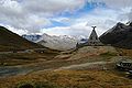
Cenotaph at the Rifugio Berni (2541 m), approx. 2 km from the Gavia Pass in a northerly direction
.jpg)


literature
- HA Berlepsch: During the hailstorm in the Alps . In: The Gazebo . Issue 12, 1866, pp. 187–190 ( full text [ Wikisource ] - illustrated by Rittmeyer).
Web links
- quaeldich.de
- YouTube video of a motorcycle ride over the Gaviapass ; Retrieved November 18, 2010
Individual evidence
- ↑ Steffan Bruns: Alpine passes - history of the alpine pass crossings . From the Inn to Lake Garda. 1st edition. tape 3 . L. Staackmann Verlag, Munich 2010, ISBN 978-3-88675-273-7 , p. 104 .
Agnello • Aprica • Assietta • Aurine • Borcola • Bordala • Brennero / Brenner • Brocon • Cadibona • Campo Carlo Magno • Campolongo • Camporosso (Saifnitzer) • Carnizza • Castrin / Hofmahd • Cereda • Ciampigotto • Cibiana • Cimabanche • Coe • Colombardo • Croce d'Aune • Croce Domini • Crocette • Costalunga / Karer • Duran • Eira • Eores / Kofel • Esischie • Erbe / Würz • Falzarego • Fauniera • Fedaia • Finero • Finestre • Foppa • Foscagno • Furcia / Furkel • Fusine (Ratschacher ) • Gavia • Gardena / Grödner • Giau • Gola / Klamml • Gran San Bernardo • Kreit • Lavazè • Livigno • Lombarda • Lúsia • Lys • Maddalena • Manghen • Mauria • Mendola / Mendel • Mont Rest • Monte Croce / Plöcken • Monte Croce di Comélico / Kreuzberg • Monte Giovo / Jaufen • Mortirolo • Nevea • Nigra / Niger • Palade / Gampen • Pampeago / Pale / Reiter • Pénnes / Penser • Pian delle Fugazze • Piccolo San Bernardo • Pordoi • Pramollo (Nassfeld) • Predil • Resia / Reschen • Rolle • Russis • Rombo / Timmel • Sampeyre • San Antonio • San Boldo • San Giovanni • San Lugano • San Marco • San Pellegrino • Santa Maria (Umbrail) • Sella • Sestriere • Sommo • Spluga (Splügen) • Stalle / Staller • Staulanza • Stelvio / Stilfser • Tanamea • Tenda • Tonale • Tre Croci • Tremalzo • Valles • Valcavera • Valparola • Vezzena • Vivione • Zovo