
Passo di Croce Domini
| Passo di Croce Domini | |||
|---|---|---|---|
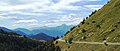
 View of the pass road in east direction |
|||
| Compass direction | northwest | south | |
| Pass height | 1895 m slm | ||
| province | Brescia Province , Lombardy | ||
| Valley locations | Breno | Bagolino | |
| expansion | Pass road | ||
| Winter closure | November to May | ||
| map | |||
|
|||
| Coordinates | 45 ° 54 '27 " N , 10 ° 24' 34" E | ||

The Passo di Croce Domini is an Italian mountain pass . It is located in Lombardy between Lake Idro in the southeast and Lake Iseo in the southwest.
Location and surroundings
The pass height is 1895 m slm , the gradient about 12%. The road from Breno (Lombardy) to Bagolino is paved throughout. The winter closure lasts from November to May.
The highest point of the route is not the Passo Croce Domini itself, but the 1943 m slm high Goletto di Cadino , which is reached from the direction of Lake Idro about one kilometer beforehand.
Like many other mountain passes and mountain roads, this one is very popular with motorcyclists because of its narrowness, but also because of its views of the landscape.
View from the top of the pass

A summit cross reminiscent of a motorcycle accident at the top of the pass


Web links
- Goletto di Cadino / Passo di Croce Domini on quaeldich.de
Agnello • Aprica • Assietta • Aurine • Borcola • Bordala • Brennero / Brenner • Brocon • Cadibona • Campo Carlo Magno • Campolongo • Camporosso (Saifnitzer) • Carnizza • Castrin / Hofmahd • Cereda • Ciampigotto • Cibiana • Cimabanche • Coe • Colombardo • Croce d'Aune • Croce Domini • Crocette • Costalunga / Karer • Duran • Eira • Eores / Kofel • Esischie • Erbe / Würz • Falzarego • Fauniera • Fedaia • Finero • Finestre • Foppa • Foscagno • Furcia / Furkel • Fusine (Ratschacher ) • Gavia • Gardena / Grödner • Giau • Gola / Klamml • Gran San Bernardo • Kreit • Lavazè • Livigno • Lombarda • Lúsia • Lys • Maddalena • Manghen • Mauria • Mendola / Mendel • Mont Rest • Monte Croce / Plöcken • Monte Croce di Comélico / Kreuzberg • Monte Giovo / Jaufen • Mortirolo • Nevea • Nigra / Niger • Palade / Gampen • Pampeago / Pale / Reiter • Pénnes / Penser • Pian delle Fugazze • Piccolo San Bernardo • Pordoi • Pramollo (Nassfeld) • Predil • Resia / Reschen • Rolle • Russis • Rombo / Timmel • Sampeyre • San Antonio • San Boldo • San Giovanni • San Lugano • San Marco • San Pellegrino • Santa Maria (Umbrail) • Sella • Sestriere • Sommo • Spluga (Splügen) • Stalle / Staller • Staulanza • Stelvio / Stilfser • Tanamea • Tenda • Tonale • Tre Croci • Tremalzo • Valles • Valcavera • Valparola • Vezzena • Vivione • Zovo