Valparola Pass
| Valparola Pass | |||
|---|---|---|---|
|
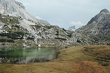
View to the north-northwest with Piz Cunturines , Valparola Lake and Passhütte |
|||
| Compass direction | Northwest | southeast | |
| Pass height | 2168 m slm | ||
| Belluno Province | |||
| Watershed | Gader → Rienz → Eisack → Etsch | Piave | |
| Valley locations | Stern ( Gadertal ) | Falzarego Pass , Cortina d'Ampezzo | |
| expansion | Strada Provinciale 24 | ||
| Mountains | Dolomites | ||
| profile | |||
| Ø pitch | 5.6% (772 m / 13.8 km) | 5.8% (87 m / 1.5 km) | |
| Map (Belluno) | |||
|
|
|||
| Coordinates | 46 ° 31 '54 " N , 11 ° 59' 20" E | ||
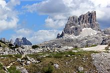
The Valparola ( Italian Passo di Valparola , gadertalisch- Ladin Ju de Valparola or Ju de Valparora ) is a mountain pass in the Italian Alps in the province of Belluno ( Veneto ) near the border with South Tyrol . It is located at an altitude of 2168 m slm south of the saddle point where the Rifugio "Passo Valparola" is located, and a little deeper is Lake Valparola . On the south side, the road climbs up to its apex of 2192 m slm , where there is a parking lot and a museum, and then leads down to the Falzarego Pass , which is just a few kilometers southeast .
The Valparola Pass is part of the watershed between the river systems of the Adige and the Piave .
history

The pass belonged to Tyrol until the First World War . The border with Italy ran a few kilometers to the east. This made the pass part of the Dolomite front, as Austria withdrew it a little beyond the actual border for strategic reasons. The old Austrian barrier fort Tra i Sassi is located on the pass . Soon after the First World War began, it was partially destroyed by Italian artillery. Some Austrian soldiers were killed. As a ruse, the Austrians continued to illuminate the fort from the inside to give the impression that it was still in use. The Italians continued to fire at the fort ruins. Today the fort is a museum.
In the past, only a mule track (Valparolajoch, also Castellopass) led over the pass , which was replaced by a developed pass road.
Surname
The Valparola got its name from the ironworks that were once near the pass. Valparola is the Latin translation of the German word "Eisenofenalpe". Ruins of these ovens, which were still in use into the 16th century, are said to have been visible in 1860. Even the Stone Age people knew the pass, as has been proven by a few finds at Lake Valparola . It can be assumed that the smelting of metal goes back at least to the Iron Age .
Blue stone
A large stone on the slope of the Hexenstein was painted blue a few years ago and has become a tourist attraction.
Web links
Individual evidence
- ↑ Steffan Bruns: Alpine passes - history of the alpine pass crossings. From the Inn to Lake Garda . 1st edition. tape 3 . L. Staackmann Verlag, Munich 2010, ISBN 978-3-88675-273-7 , p. 175 .
- ↑ Blauer Stein am Valparola Pass ( Memento of the original from December 27, 2013 in the Internet Archive ) Info: The archive link was inserted automatically and has not yet been checked. Please check the original and archive link according to the instructions and then remove this notice. on Panoramio.


