
Witch stone
| Witch stone | ||
|---|---|---|
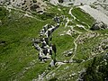
 Hexenstein from the east (from the Falzarego pass ) |
||
| height | 2477 m slm | |
| location | Veneto , Italy | |
| Mountains | Dolomites | |
| Dominance | 0.85 km → Lagazuoi Piccolo | |
| Notch height | 285 m ↓ Valparola Pass | |
| Coordinates | 46 ° 31 '16 " N , 11 ° 59' 49" E | |
|
||
| Normal way | Hiking trail from the north, finally a small via ferrata | |

The Hexenstein or Hexenfels ( Italian Sasso di Stria , Ladin Sass de Stria ) is a summit in the Dolomites ( Belluno Province , Veneto region / Italy ). The steep rock is 2,477 m high and rises between Passo Falzarego and Valparola - approximately at the height of the former imperial -Forts Tre Sassi - opposite the Tofana di Rozes and their upstream rock massif Lagazuoi .
The panoramic view from the summit extends to the Puez group in the north over the Sella and Marmolada in the west and southwest, the Passo Falzarego in the south and the Lagazuoi and the Tofane in the east.
history
The Hexenstein was a central combat area in the mountain war of 1915–1918 . He took a strategically important corner position for the Austro-Italian front, which ran from the Valparola pass to the Col di Lana over the Buchensteintal ( Livinallongo ). The obsolete, repeatedly bombarded by the Italians since 1915 Forte Tre Sassi has its locking function to defend the Austrian Val Badia are no longer met and had given up. Instead, the Hexenstein, on which there was originally only a small field guard, was initially unnoticed by the Italians and expanded into a fortress. The guns were at the rear on the north slope, the summit was an observation post. After the Italians failed to take the position, mine war broke out in 1916 with a total of 5 explosions at Lagazuoi, without the Italians breaking through.
In the second half of the 20th century, the Hexenstein became a hiking and climbing area in the course of the tourist development. The trenches and tunnels have been restored and partially made accessible again.
The position of Major General Ludwig Goiginger is documented with a memorial plaque for the Kaiserjäger on a forecrown of the Hexenstein .
Development
The summit can be reached in 1 - 1.5 hours on the historic mule path on the north side, starting from the road on the Valparola Pass at the level of Fort Tre Sassi. The trail has only been clearly marked and in its last section developed as a via ferrata ( difficulty A – B ) since 1996. It leads past the war positions and, in one variant, even through a tunnel . The Hexenstein-Südkante ( UIAA IV + ) is a popular climbing route . There is a climbing garden at the eastern foot of the mountain .

Tunnel below the summit

The rise through the tunnel, secured by wire rope
The Goiginger position at the southern foot


literature
- Anette Köhler, Norbert Memmel: Climbing Guide Dolomites . Bergverlag Rother , ISBN 3-7633-3015-1
Web links
Individual evidence
- ↑ Hexenstein with Goiginger tunnel. (No longer available online.) Klettersteig.de, formerly in the original ; Retrieved April 25, 2008 . ( Page no longer available , search in web archives ) Info: The link was automatically marked as defective. Please check the link according to the instructions and then remove this notice.
- ^ Andi Riesner: Hexenstein Südkante. (No longer available online.) Bergstieg.com, formerly in the original ; Retrieved April 25, 2008 . ( Page no longer available , search in web archives ) Info: The link was automatically marked as defective. Please check the link according to the instructions and then remove this notice.
- ↑ http://www.x63.it/?Sas-de-Stria-Klettergarten-I