
Splügen Pass
| Splügenpass / Passo dello Spluga | |||
|---|---|---|---|

|
|||
| Compass direction | North | south | |
| Pass height | 2114 m above sea level M. | ||
| region |
Canton of Graubünden Switzerland |
Province of Sondrio Italy |
|
| Watershed | Hüscherabach → Hinterrhein → Rhine | Liro → Mera → Lake Como → Adda → Po | |
| Valley locations | Splügen | Chiavenna | |
| expansion | Main street 567 |
|
|
| Built | 1821-1823 | ||
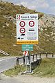
| Lock | November - May | ||
| Mountains |
Tambogroup (west) Platta group (east) |
||
| profile | |||
| Denzel scale | SG 2-3 | SG 2-3 | |
| Ø pitch | 7.1% (638 m / 9 km) | 5.9% (1780 m / 30 km) | |
| Max. Incline | 11% | 13% | |
| map | |||
|
|||
|
|||
| Coordinates , ( CH ) | 46 ° 30 '20 " N , 9 ° 19' 49" O ( 745 183 / 152221 ) | ||


The Splügen Pass ( Italian Passo dello Spluga , Rhaeto-Romanic Pass dal Spleia ) lies at an altitude of 2114 m above sea level. M. , connects Splügen in the Swiss Rheinwald in the canton of Graubünden (north side) with Chiavenna in the Italian province of Sondrio and Lake Como (south side) and separates the tambogroup in the west from the Platta group in the east, thus also on the dividing line between the western Alps and the eastern Alps lies. The watershed between the Rhine and the Po runs over the pass and corresponds to the border between Switzerland and Italy .
The Hüscherabach rises on the north side of the pass and flows into the Hinterrhein in Splügen . The Bergseeli lies to the east above the pass .
history

The pass was already known to the Romans , probably under the name “Cunus Aureus” - “golden tip”, if that did not refer to the Julier Pass . Splügen is said to derive from “specula”, Latin for “lookout” or from the Romanic “Speluca” “cave” and was apparently also used in the Middle Ages. At the expense of the Oberen Strasse over the Septimerpass , which was sponsored by the influential Chur bishop , it also lost its importance because the poorly maintained access route on the Hinterrhein increasingly fell into disrepair. This is why the gorge and path have been called Viamala (“bad way”) since the 13th century and only after the Heinzenberg communities Thusis , Masein and Cazis decided in 1473 to repair “the richstrass and the waeg” did the route over the Splügen develop the most important Graubünden transit route and enabled regular "course traffic" such as that of the Lindauer Bote .
Today's street was built by the Austrians , who ruled Milan at the time, at their own expense and completed in the summer of 1822. Since the construction of a tunnel through the San Bernardino , the pass has largely lost its former importance. In the 19th century there were plans to build a railway line over the Splügen; However, these failed due to the resistance of the canton of Ticino , which would have been bypassed. Ultimately, preference was given to building the first Gotthard tunnel .
In the 1980s, a 46.7 km long Splügen base tunnel between Thusis and Chiavenna was discussed. It was one of five railway tunnel projects discussed in the Swiss Alps. The project was postponed in favor of the Gotthard and Lötschberg base tunnels .
Splügen Gallery

The 312 meter long gallery on the Splügen Pass was built in 1843–1846, refurbished for the first time in 1991 and refurbished a second time from 2006 to 2011.
The Splügen route was previously considered dangerous. In December 1800, the 15,000-strong army of French Marshal Jacques MacDonald marched across the Splügen Pass towards Chiavenna despite a raging snow storm. Hundreds of soldiers were killed by avalanches. Several road houses and galleries were built to protect travelers, haulers and carters . The gallery on the north side is the only one that still exists today. It was built between 1843 and 1846 and is 312 meters long. The gallery was built according to the project of the engineer Carlo Donegani and was under the supervision of the cantonal engineer Richard La Nicca .
After the Second World War , the Splügen Pass remained closed in winter and the gallery was bypassed with a summer road. In August 1991 the gallery was partially renovated. A new surface was installed and the edges were repaired.
The rising natural stone masonry of the gallery is traditionally built with two shells, with the core being filled with residual materials. A system of inlet shafts, collecting basins and cross-cuts under the gallery ensured the drainage of the slope water. Over time, the drainage structures clogged and the vault seal began to leak. In winter, frost in the masonry caused part of the vault to collapse.
In the years 2006 to 2011, 60 meters from the northern section of the gallery were repaired and prepared for future use as an exhibition space. The remaining length of the vault was restored in the area of the collapse site, the walls were structurally secured and grouted, the drainage structures repaired and the sealing renewed. The complete renovation cost a total of 2,015,000 francs.

Route
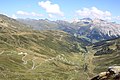
The nine-kilometer north ramp from Splügen reaches the top of the pass via two groups of bends, one with six bends behind Splügen, the other with fifteen bends before the pass. There is the former border station, a restaurant is operated on the weekends in the Berghaus Splügenpass. The south ramp (SS 36) through the Italian Val San Giacomo is remarkable : between the pass summit and Chiavenna , a height difference of almost 1800 meters has to be overcome over a distance of about 30 kilometers. The route leads past Lago di Montespluga , Madesimo , Lago d'Isola and Campodolcino to Chiavenna. From here are Lake Como or the Maloja Pass to reach. The road is paved throughout and has two lanes. The pass is closed in winter.
Others
- Above Splügen the pass road leads over the marble bridge .
- 100 m east of the road, the Via Spluga cultural and long-distance hiking trail leads along the historic mule track over the Splügen Pass; here is a height of 2113 m above sea level. M. (cf. picture from the signpost), so that this is the actual pass (saddle point), therefore the name Strassenpass is also used in the maps of Switzerland for the apex of the road.
- Not far from the top of the pass road, a quartzite in plate form was extracted at an altitude of 2100 meters. It was used for roofing in the region. The dismantling is stopped.
- The road over the pass consists of 75 switchbacks; 52 of them are on the Italian and 23 on the Swiss side.
photos

Sweeping on the north side
Pass height
Swiss side of the pass road with a view of the Teurihorn
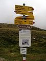
Mule track 2113 m above sea level M.

Panorama north side of the Splügen Pass


See also
- Shipping canal projects in the Alps , including the unrealized Splügen Canal
literature
- Jürg Simonett: Splügen Pass. In: Historical Lexicon of Switzerland . January 10, 2013 .
Web links
- Splügenpass on the ETHorama platform
Individual evidence
- ↑ a b map.geo.admin.ch. In: map.geo.admin.ch. Retrieved April 3, 2014 .
- ↑ Horst Schmollinger: The Lindauer Bote. tag-der-briefmarke.org from December 26, 2014, accessed on May 24, 2016.
- ↑ Bündner Calendar 2010, p. 113
- ↑ Two new rail tunnels through the Alps. In: Frankfurter Allgemeine Zeitung , May 12, 1989, p. 11.
- ↑ a b c Kurt Wanner, Montemarzino / Splügen (kw) Marcus Schmid, Chur (ms) Marcus Casutt, Chur (mc): The gallery on the Splügen pass. (PDF) Retrieved March 30, 2017 .
- ↑ Arne Hegland, Jürg Simonett: Roads as architectural monuments .
- ↑ a b Practical example gallery on Splügenpass. (PDF) (No longer available online.) Archived from the original on March 31, 2017 ; accessed on March 30, 2017 . Info: The archive link was inserted automatically and has not yet been checked. Please check the original and archive link according to the instructions and then remove this notice.
- ↑ F. de Quervain: The usable rocks of Switzerland. Bern (Kümmerly & Frey) 1969, p. 91
Ächerli • Agites • Aiguillon • Albis • Albula • Balmberg • Benkerjoch • Bernina • Böhler • Bözberg • Breitehöchi • Brünig • Buechenegg • Bürersteig • Chall • Challhöchi Pass • Champex • Chasseral • Chatzenstrick • Chilchzimmersattel • Croix • Croix • Croix de Coeur • Eichhöhe • Étroits • Etzelpass • Flüela • Forclaz • Furka • Ghöch • Givrine • glass • Glaubenberg • Glaubenbielen • Gottschalkenberg • Grimsel • Grosse Scheidegg • Gr.St.Bernhard • Gurnigel • Haggenegg • Hahnenmoos • Heitersberg • Hilferen • Hirzel • Hirzel Höhi • Hulftegg • Ibergeregg • Jaman • Jaun • Julier • Kerenzerberg • Klausen • Kunkels • Lein • Lenzerheide • Livigno • Lukmanier • Maloja • Marchairuz • Mollendruz • Mont Crosin • Monte Ceneri • Mont d'Orzeires • Montvoie • Morgins • Mosses • Mutschellen • Neggia • Nufenen • Oberalp • upper Hauenstein • Oberricken • oven • Orn • Passwang • Pierre Pertuis • Pillon • Planches • Pontins • Pragel • edge crossing • Rangiers • rates • Rengg • crocheted • Roches • 'groups • R üsler • Saanenmöser • Salhöhe • San Bernardino • Sanetsch • Santelhöchi • Sattel • Sattelegg • Schafmatt • Schallenberg • Schelten • Schönau • Schufelberger Egg • Schwägalp • Schwarzenbühl • Siblingerhöhe • Simplon • Splügen • St. Anton • St. Gotthard • St. Luzisteig • Staffelegg • Stoss • Susten • Tourne • Tronc • Umbrail • Unterer Hauenstein • Front Höhi • Vue des Alpes • Wasserfluh • Weissenstein • Wildhaus • Wissegg • Wolfgang
Agnello • Aprica • Assietta • Aurine • Borcola • Bordala • Brennero / Brenner • Brocon • Cadibona • Campo Carlo Magno • Campolongo • Camporosso (Saifnitzer) • Carnizza • Castrin / Hofmahd • Cereda • Ciampigotto • Cibiana • Cimabanche • Coe • Colombardo • Croce d'Aune • Croce Domini • Crocette • Costalunga / Karer • Duran • Eira • Eores / Kofel • Esischie • Erbe / Würz • Falzarego • Fauniera • Fedaia • Finero • Finestre • Foppa • Foscagno • Furcia / Furkel • Fusine (Ratschacher ) • Gavia • Gardena / Grödner • Giau • Gola / Klamml • Gran San Bernardo • Kreit • Lavazè • Livigno • Lombarda • Lúsia • Lys • Maddalena • Manghen • Mauria • Mendola / Mendel • Mont Rest • Monte Croce / Plöcken • Monte Croce di Comélico / Kreuzberg • Monte Giovo / Jaufen • Mortirolo • Nevea • Nigra / Niger • Palade / Gampen • Pampeago / Pale / Reiter • Pénnes / Penser • Pian delle Fugazze • Piccolo San Bernardo • Pordoi • Pramollo (Nassfeld) • Predil • Resia / Reschen • Rolle • Russis • Rombo / Timmel • Sampeyre • San Antonio • San Boldo • San Giovanni • San Lugano • San Marco • San Pellegrino • Santa Maria (Umbrail) • Sella • Sestriere • Sommo • Spluga (Splügen) • Stalle / Staller • Staulanza • Stelvio / Stilfser • Tanamea • Tenda • Tonale • Tre Croci • Tremalzo • Valles • Valcavera • Valparola • Vezzena • Vivione • Zovo