
Lake Isola
| Lake Isola | |||||||||||
|---|---|---|---|---|---|---|---|---|---|---|---|
 |
|||||||||||
|
|||||||||||
|
|||||||||||
| Coordinates | 734 407 / 145 794 | ||||||||||
| Data on the structure | |||||||||||
| Lock type: | Arch weight wall | ||||||||||
| Construction time: | 1957 to 1963 | ||||||||||
| Height of the barrier structure : | 45 m | ||||||||||
| Height above the river bed : | 39 m | ||||||||||
| Crown length: | 290 m | ||||||||||
| Crown width: | 5.5 m | ||||||||||
| Data on the reservoir | |||||||||||
| Altitude (at congestion destination ) | 1604 m | ||||||||||
| Water surface | 3.9 km² | ||||||||||
| Reservoir length | 1 km | ||||||||||
| Storage space | 6.5 million m³ | ||||||||||
| Catchment area | 43 km² | ||||||||||
| Design flood : | 300 m³ / s | ||||||||||

The Lago d'Isola is a reservoir in the canton of Graubünden south of the village of San Bernardino in the municipality of Mesocco .
The length of the actual lake is around one kilometer. To the north of this, a narrow arm of water - the dammed Moësa - extends for another kilometer almost to the village of San Bernardino. The A13 runs along the east side of the lake . The dam was built between 1957 and 1963. The dam is owned and operated by the “Officine Idroelettriche di Mesolcina SA”.
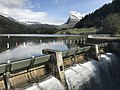
Overflow when the water level is very high
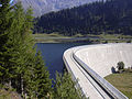
Dam wall


Web links
- Lago d'Isola on swissdams.ch/fr on schweizersee.ch
- Lago d'Isola on schweizersee.ch
Individual evidence
- ↑ swissdams ( Memento of the original from January 9, 2016 in the Internet Archive ) Info: The archive link was inserted automatically and has not yet been checked. Please check the original and archive link according to the instructions and then remove this notice.
Swiss reservoirs with a content of over 10 million m³:
Albignasee |
Arnensee |
Lac de Barberine |
Lago Bianco |
Lac Brenet |
Lago dei Cavagnöö |
Lac de Cleuson |
Lai da Curnera |
Davosersee |
Lac des Dix |
Lac d'Emosson |
Engstlensee |
Gelmersee |
Gigerwaldsee |
Göscheneralpsee |
Lake Gruyère |
Griessee |
Grimselsee |
Lac de l'Hongrin |
Klingnau Reservoir |
Klöntalersee |
Lake Lei |
Limmerensee |
Lake Livigno |
Lake Lucendro |
Lungerersee |
Lake Luzzone |
Lai da Marmorera |
Mattmarksee |
Lac de Mauvoisin |
Lac de Moiry |
Lac de Montsalvens |
Lac de Moron |
Muttsee |
Lai da Nalps |
Lake Naret |
Oberaarsee |
Lac de Pérolles |
Lake Poschiavo |
Raeterichsbodensee |
Lake Ritóm |
Lac de Salanfe |
Lago del Sambuco |
Schiffenensee |
Sihlsee |
Lai da Sontga Maria |
Sufnersee |
Lac des Toules |
Lake Tremorgio |
Lac de Tseuzier |
Lac du Vieux Emosson |
Lake Vogorno |
Wägitalersee |
Wohlensee |
Zervreila Lake