
Limmerensee
| Limmerensee | |||||||||
|---|---|---|---|---|---|---|---|---|---|
 |
|||||||||
|
|||||||||
|
|||||||||
| Coordinates | 720 189 / 188363 | ||||||||
| Data on the structure | |||||||||
| Lock type: | Arch dam | ||||||||
| Construction time: | 1960 to 1963 | ||||||||
| Height of the barrier structure : | 145.5 m | ||||||||
| Height above the river bed : | 122 m | ||||||||
| Height of the structure crown: | 1860 m above sea level M. | ||||||||
| Building volume: | 553 000 m³ | ||||||||
| Crown length: | 375 m | ||||||||
| Crown width: | 9 m | ||||||||
| Base width: | 25 m | ||||||||
| Operator: | Kraftwerke Linth-Limmern AG , Linthal | ||||||||
| Data on the reservoir | |||||||||
| Altitude (at congestion destination ) | 1857 m above sea level M. | ||||||||
| Water surface | 1.36 km² | ||||||||
| Reservoir length | 3 km | ||||||||
| Reservoir width | 400 to 700 m | ||||||||
| Maximum depth | 125 m | ||||||||
| Storage space | 92 000 000 m³ | ||||||||
| Total storage space : | 93 000 000 m³ | ||||||||
| Catchment area | 17.8 km² | ||||||||
| Design flood : | 130 m³ / s | ||||||||
 |
|||||||||

The Limmerensee (also Limmernsee ) is a storage lake owned by Kraftwerke Linth-Limmern (KLL) AG in the southernmost part of the political municipality of Glarus Süd , in the Swiss canton of Glarus .
location
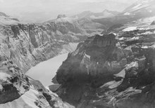
The Limmerensee is located in the former headwaters of the Limmerenbach in the Limmerenboden in the rearmost part of the Limmerental. The lake is fed by the melting water from the Griess and Limmeren glaciers and the surrounding mountain ranges. The two glaciers are located on the north side of the Bifertenstock ( 3419 m ) southwest of the reservoir . The Muttenbach flows into the northern part of the lake, through which the meltwater of the Latten and Muttenalp flows away. After leaving the lake, the Limmerenbach flows through the Limmerental. On its way to the Üelialp , where it joins the Linth , it picks up various small mountain streams from left and right. The Limmerensee is embedded in high mountains. Next to the Bifertenstock on the west side of the lake are the Selbsanft Mountains (with heights up to 2494 m ), in the north the Muttenchopf ( 2482 m ), in the northeast the Muttenstock ( 3088 m ), in the east the Muttenberge (with heights up to 2954 m ) m ) and in the southeast the Kistenstöckli ( 2747 m ).
history
In the 19th century, the Limmern Bach collected the meltwater of the Gries and Limmern glacier from the Limmernboden on the west side and the meltwater of the Kistenband on the east side and that of the Latten Glacier and Muttenalp via the Muttenbach. Depending on the time of year, small mountain streams were created, which led their water into the Limmern Bach. The Limmern Bach flowed through the Limmern Thal and flowed into the Linth River in the Linth Thal at Ueli Alp.
The Limmerensee has only existed since 1963. The entire area of the Limmerenboden at Ochsenplangge was separated by the 122 meter high Limmern arch dam . The Limmerensee serves as a reservoir for the pumped storage power plant of the Linth-Limmern power plants.
Linth-Limmern power plants
The Limmerensee is part of the energy generation systems of the Linth-Limmern power plants.
Dam wall

The dam wall consists of 553,000 m³ of concrete. It was designed as a double-curved arch dam. In order to prevent any water loss under the wall, an injection shield up to 170 meters deep was created under the foundation.
A flood relief protects the dam wall from damage by inflows above the maximum water level. An overflow drains the water through a tunnel with a capacity of up to 89 m³ / s. If the lake has to be emptied, this is done via a bottom outlet at the foot of the dam with an output of up to 98 m³ / s.
reachability

The reservoir is accessed via Linthal and Tierfehd to the valley station of the Tierfehd - Kalktrittli aerial cableway operated by Kraftwerke Linth-Limmern AG. The railway overcomes a difference in altitude of 1060 meters in 7½ minutes, which would require a good four hours of ascent on foot. From Kalktrittli, a three-kilometer-long power plant tunnel that ends at Limmerensee serves as a hiking trail. The path continues to the Muttseehütte ( SAC ) (2501 m above sea level) on the Muttenalp with a view of the Muttsee with the longest dam in Switzerland (time required from Kalktrittli about 2½ hours). The mountain station can be reached from the hut via a hiking trail in around 2½ hours. This path is well secured, but only recommended for mountaineers with a head for heights. Footwear suitable for the mountains is required.
Web links
Individual evidence
- ↑ Height information and names according to: Swiss Confederation (geo.admin.ch): Maps of Switzerland . Retrieved February 27, 2020
- ↑ The names correspond to the spelling of the time and are taken from the online maps of the Swiss Confederation (map.geo.admin.ch)
- ↑ ETH Zurich (e-priodica.ch): The Linth-Limmern power plant in the canton of Glarus . In: Appenzell calendar. Volume 246, 1967. Retrieved March 2, 2020
- ↑ Swissdams.ch: Limmernboden . Technical data (pdf). Retrieved March 2, 2020
- ↑ Muttseehütte: location - approach . Retrieved February 27, 2020
Swiss reservoirs with a content of over 10 million m³:
Albignasee |
Arnensee |
Lac de Barberine |
Lago Bianco |
Lac Brenet |
Lago dei Cavagnöö |
Lac de Cleuson |
Lai da Curnera |
Davosersee |
Lac des Dix |
Lac d'Emosson |
Engstlensee |
Gelmersee |
Gigerwaldsee |
Göscheneralpsee |
Lake Gruyère |
Griessee |
Grimselsee |
Lac de l'Hongrin |
Klingnau Reservoir |
Klöntalersee |
Lake Lei |
Limmerensee |
Lake Livigno |
Lake Lucendro |
Lungerersee |
Lake Luzzone |
Lai da Marmorera |
Mattmarksee |
Lac de Mauvoisin |
Lac de Moiry |
Lac de Montsalvens |
Lac de Moron |
Muttsee |
Lai da Nalps |
Lake Naret |
Oberaarsee |
Lac de Pérolles |
Lake Poschiavo |
Raeterichsbodensee |
Lake Ritóm |
Lac de Salanfe |
Lago del Sambuco |
Schiffenensee |
Sihlsee |
Lai da Sontga Maria |
Sufnersee |
Lac des Toules |
Lake Tremorgio |
Lac de Tseuzier |
Lac du Vieux Emosson |
Lake Vogorno |
Wägitalersee |
Wohlensee |
Zervreila Lake