
Sufnersee
| Sufnersee | |||||||||
|---|---|---|---|---|---|---|---|---|---|
 |
|||||||||
|
|||||||||
|
|||||||||
| Coordinates | 748 148 / 159151 | ||||||||
| Data on the structure | |||||||||
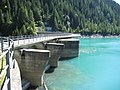
| Lock type: | Arch dam | ||||||||
| Construction time: | 1962 | ||||||||
| Height of the barrier structure : | 58 m | ||||||||
| Height above the river bed : | 51 m | ||||||||
| Building volume: | 22nd 100 m³ | ||||||||
| Crown length: | 125 m | ||||||||
| Operator: | Kraftwerke Hinterrhein AG, Thusis | ||||||||
| Data on the reservoir | |||||||||
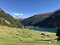
| Altitude (at congestion destination ) | 1401 m above sea level M. | ||||||||
| Water surface | 90 ha | ||||||||
| Reservoir length | 2.2 km | ||||||||
| Storage space | 18th 300 000 m³ | ||||||||
| Total storage space : | 21st 400 000 m³ | ||||||||
| Catchment area | 194 km² | ||||||||
| Design flood : | 594 m³ / s | ||||||||
 |
|||||||||

The Sufnersee is located in the canton of Graubünden in the area of the communities of Sufers and Rheinwald . The lake can be reached via the San Bernardino route. The A13 runs along the lake . The only place on the lake is Sufers.
The Sufers dam was completed in 1962. Around 30 hectares of meadow land were lost. To compensate for this loss, the existing humus was extracted from the storage space during construction and distributed over poor soil. With these soil improvements it was possible to increase agricultural production. There is no power plant at the lake, the water is directed to the Bärenburg headquarters or via the Lago di Lei reservoir and the Ferrera compensation basin to the Ferrera headquarters.
Weir

inflow
View of the wall


swell
- Lakes in Switzerland: Natural and storage lakes, Federal Office for the Environment FOEN, 2007 ( Memento from October 5, 2008 in the Internet Archive ) → Lakes in Switzerland (PDF)
Web links
- Sufnersee on schweizersee.ch
- Kraftwerke Hinterrhein AG
Individual evidence
Swiss reservoirs with a content of over 10 million m³:
Albignasee |
Arnensee |
Lac de Barberine |
Lago Bianco |
Lac Brenet |
Lago dei Cavagnöö |
Lac de Cleuson |
Lai da Curnera |
Davosersee |
Lac des Dix |
Lac d'Emosson |
Engstlensee |
Gelmersee |
Gigerwaldsee |
Göscheneralpsee |
Lake Gruyère |
Griessee |
Grimselsee |
Lac de l'Hongrin |
Klingnau Reservoir |
Klöntalersee |
Lake Lei |
Limmerensee |
Lake Livigno |
Lake Lucendro |
Lungerersee |
Lake Luzzone |
Lai da Marmorera |
Mattmarksee |
Lac de Mauvoisin |
Lac de Moiry |
Lac de Montsalvens |
Lac de Moron |
Muttsee |
Lai da Nalps |
Lake Naret |
Oberaarsee |
Lac de Pérolles |
Lake Poschiavo |
Raeterichsbodensee |
Lake Ritóm |
Lac de Salanfe |
Lago del Sambuco |
Schiffenensee |
Sihlsee |
Lai da Sontga Maria |
Sufnersee |
Lac des Toules |
Lake Tremorgio |
Lac de Tseuzier |
Lac du Vieux Emosson |
Lake Vogorno |
Wägitalersee |
Wohlensee |
Zervreila Lake