
Lac de Montsalvens
| Lac de Montsalvens | |||||||||
|---|---|---|---|---|---|---|---|---|---|
 |
|||||||||
|
|||||||||
|
|||||||||
| Coordinates | 577 080 / 162 404 | ||||||||
| Data on the structure | |||||||||
| Lock type: | Arch dam | ||||||||
| Construction time: | 1920 | ||||||||
| Height of the barrier structure : | 55 m | ||||||||
| Height above the river bed : | 50 m | ||||||||
| Height of the structure crown: | 801 m above sea level M. | ||||||||
| Building volume: | 26th 000 m³ | ||||||||
| Crown length: | 115 m | ||||||||
| Crown width: | 2 m | ||||||||
| Base width: | 22 m | ||||||||
| Operator: | Groupe E | ||||||||
| Data on the reservoir | |||||||||
| Water surface | 74 ha | ||||||||
| Reservoir length | 2.7 km | ||||||||
| Storage space | 11 000 000 m³ | ||||||||
| Total storage space : | 12 600 000 m³ | ||||||||
| Catchment area | 173 km² | ||||||||
| Design flood : | 274 m³ / s | ||||||||
| Particularities: |
Oldest arch dam in Europe |
||||||||
 |
|||||||||

The Lac de Montsalvens is a Swiss reservoir.
The reservoir is on the way to the Jaunpass , between the towns of Broc and Charmey . Half of the dam is located in the municipal area of Broc and Châtel-sur-Montsalvens . The lake fills parts of the two side valleys Javroz and Motélon below the village of Charmey.
history
The plant was planned on the one hand by Lausanne Professor Jean Landry (overall planning) and engineer Heinrich Eduard Gruner (and Alfred Stucky from his engineering office) from Basel on the other.
At the Grand Council meeting on 17./18. May 1918 the construction of the dam was approved.
The Montsalvens dam was completed in 1920, and in 1921 the lake was filled with water.
The cost of building the facility was estimated at 11 million SFr. In the end, however, the total costs amounted to CHF 21 million, which is an excess of 91%. This cost explosion brought the Freiburg Electricity Works into severe financial difficulties for a short time.
photos

Dam of the Lac de Montsalvens

Dam of the Lac de Montsalvens

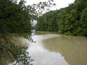
View of the lake from the dam

Lac de Montsalvens, suspension bridge on the peninsula
Lac de Montsalvens, near the peninsula

map

swell
- Lakes in Switzerland: Natural and storage lakes, Federal Office for the Environment FOEN, 2007 ( Memento from October 5, 2008 in the Internet Archive ) → Lakes in Switzerland (PDF)
Swiss reservoirs with a content of over 10 million m³:
Albignasee |
Arnensee |
Lac de Barberine |
Lago Bianco |
Lac Brenet |
Lago dei Cavagnöö |
Lac de Cleuson |
Lai da Curnera |
Davosersee |
Lac des Dix |
Lac d'Emosson |
Engstlensee |
Gelmersee |
Gigerwaldsee |
Göscheneralpsee |
Lake Gruyère |
Griessee |
Grimselsee |
Lac de l'Hongrin |
Klingnau Reservoir |
Klöntalersee |
Lake Lei |
Limmerensee |
Lake Livigno |
Lake Lucendro |
Lungerersee |
Lake Luzzone |
Lai da Marmorera |
Mattmarksee |
Lac de Mauvoisin |
Lac de Moiry |
Lac de Montsalvens |
Lac de Moron |
Muttsee |
Lai da Nalps |
Lake Naret |
Oberaarsee |
Lac de Pérolles |
Lake Poschiavo |
Raeterichsbodensee |
Lake Ritóm |
Lac de Salanfe |
Lago del Sambuco |
Schiffenensee |
Sihlsee |
Lai da Sontga Maria |
Sufnersee |
Lac des Toules |
Lake Tremorgio |
Lac de Tseuzier |
Lac du Vieux Emosson |
Lake Vogorno |
Wägitalersee |
Wohlensee |
Zervreila Lake