Lac de Moron
| Lac de Moron | |||||||
|---|---|---|---|---|---|---|---|
|
|||||||
|
|
|||||||
| Coordinates | 547 019 / 215 835 | ||||||
| Data on the structure | |||||||
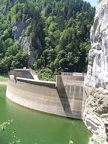
| Lock type: | Arch dam | ||||||
| Construction time: | 1953 | ||||||
| Height of the barrier structure : | 74 m | ||||||
| Height above the river bed : | 59 m | ||||||
| Height of the structure crown: | 716 m above sea level M. | ||||||
| Building volume: | 48 000 m³ | ||||||
| Crown length: | 150 m | ||||||
| Operator: | Groupe E | ||||||
| Data on the reservoir | |||||||
| Water surface | 0.69 km² | ||||||
| Reservoir length | 3.3 km | ||||||
| Storage space | 15th 800 000 m³ | ||||||
| Total storage space : | 20th 600 000 m³ | ||||||
| Catchment area | 911 km² | ||||||
| Design flood : | 500 m³ / s | ||||||
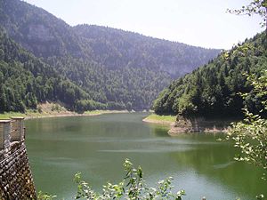
The Lac de Moron is a reservoir in the Jura on the border between Switzerland and France . The lake begins with the Saut du Doubs , an imposing 27 meter high waterfall and has a striking greenish color.
The reservoir can be reached on foot from the French side from the village of Le Barboux , which is located in the Doubs department . On the Swiss side, the reservoir can be reached via the villages of Les Brenets , Le Locle and Les Planchettes .
history
The Châtelot dam was completed in 1953.
swell
- Lakes in Switzerland: Natural and storage lakes, Federal Office for the Environment FOEN, 2007 ( Memento of October 5, 2008 in the Internet Archive ) (PDF)


