
Klöntalersee
| Klöntalersee | |||||||||
|---|---|---|---|---|---|---|---|---|---|
 |
|||||||||
|
|||||||||
|
|||||||||
| Coordinates | 717 210 / 209430 | ||||||||
| Data on the structure | |||||||||
| Lock type: | Erdschüttdamm (dam Rhodannenberg) | ||||||||
| Construction time: | Completion in 1910 | ||||||||
| Height of the barrier structure : | 30 m | ||||||||
| Height above the river bed : | 47 m | ||||||||
| Height of the structure crown: | 848 m above sea level M. | ||||||||
| Crown length: | 217 m | ||||||||
| Operator: | Nordostschweizerische Kraftwerke AG, Baden | ||||||||
| Data on the reservoir | |||||||||
| Water surface | 3.29 km² | ||||||||
| Reservoir length | 5 km | ||||||||
| Storage space | 39 800 000 m³ | ||||||||
| Total storage space : | 56 400 000 m³ | ||||||||
| Catchment area | 82.82 km² | ||||||||
| Design flood : | 200 m³ / s | ||||||||
 |
|||||||||

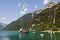
The Klöntalersee is a natural lake created by a sagging from the southern flank and a landslide from the northern flank of the valley , which was dammed into a reservoir with an embankment dam . It is located in the Klöntal in the Canton of Glarus in Switzerland at an altitude of 848 m above sea level. M. and has an area of about 3.3 km².
geography
The Klöntalersee lies in a deeply cut side valley of the Linth valley above Glarus . To the south of the lake rises the Glärnisch ( 2904 m above sea level ), in the north the Dejenstogg ( 2012 m above sea level ). A geological subsidence on the Glärnisch side led to the emergence of the Sackberg up to the Vorder Sackberg . This sack also includes the Bergli right next to the city of Glarus and the small church hill of the Catholic castle chapel St. Michael in Glarus. A landslide occurred on the northern Dejenstogg side from a demolition area that was clearly visible to the east of the summit.
The main tributary is the Klön , called Chlü in Glarus German . The outflow is the Löntsch , which flows into the Linth at Netstal and gives the power plant operated by Axpo its name: Kraftwerk am Löntsch .
To the north in the next valley lies the Obersee , which was also naturally dammed, but whose water flows underground.
At the eastern end south of the Klöntalersee is the Güntlenau campground , at the western end of the lake the Vorauen area of the Glarnerland cooperative tent club (ZKG).
history
Since 1908, the Klöntalersee has been used to generate electricity. It is the oldest large reservoir in Switzerland, after it was dammed by an earth dam 21.5 m high.
Before the ice machines were invented, ice was mined commercially when the Klöntalersee was frozen over. This was last done in 1953 by the Wädenswil brewery .
In the 17th century, inferior iron ore was mined from the Glarus stand below the present dam .
Development
On the north side, the pass road leads from the dam in the direction of Vorauen – Richisau– Pragelpass to Muotathal ( Canton Schwyz ).
On the south side, a hiking trail between the rock face and the lake leads past, among other things, a memorial for Salomon Gessner erected there from local stone in 1788 .
"Anyone who has seen their loneliness once in favorable light can never forget the picture for their entire life."

Klöntalersee seen from the southern flank of the Wiggis with the original natural damming visible
Overflow structure in the lake

Klöntalersee around 1900

Klöntalersee, August 8, 1932


Web links
Individual evidence
- ↑ Axpo (ed.): Hydropower plant on the Löntsch . Factsheet. November 2016 ( axpo.com [PDF]).
- ^ Peter Kaiser: Stauwerke. In: Historical Lexicon of Switzerland .
- ↑ A contemporary witness reports - natural ice instead of freezer. In: srf.ch . January 28, 2020, accessed January 31, 2020 .
- ↑ FredySen: Eisgewinnung im Klöntal 1953 (Video, 12:41; Naturalis -gewinnung im Klöntal, a contemporary document from around 1953. Original recordings by Hans Schönwetter, photographer and filmmaker in Glarus. Editing by Fredy Leuenberger, hotelier and amateur filmmaker in Glarus. Comment spoken by Hans Feldmann, farmer and innkeeper in Glarus) youtube.com, upload March 16, 2011, accessed February 4, 2017. - Cutting uniformly about 1x1 m large slabs of about 25 cm thick ice on the lake by hand with pull saws, pulling over the surface of the water with hook bars, with iron hooks over slides made of two wooden poles out of the water, onto low wooden sleds and discharge.
Swiss reservoirs with a content of over 10 million m³:
Albignasee |
Arnensee |
Lac de Barberine |
Lago Bianco |
Lac Brenet |
Lago dei Cavagnöö |
Lac de Cleuson |
Lai da Curnera |
Davosersee |
Lac des Dix |
Lac d'Emosson |
Engstlensee |
Gelmersee |
Gigerwaldsee |
Göscheneralpsee |
Lake Gruyère |
Griessee |
Grimselsee |
Lac de l'Hongrin |
Klingnau Reservoir |
Klöntalersee |
Lake Lei |
Limmerensee |
Lake Livigno |
Lake Lucendro |
Lungerersee |
Lake Luzzone |
Lai da Marmorera |
Mattmarksee |
Lac de Mauvoisin |
Lac de Moiry |
Lac de Montsalvens |
Lac de Moron |
Muttsee |
Lai da Nalps |
Lake Naret |
Oberaarsee |
Lac de Pérolles |
Lake Poschiavo |
Raeterichsbodensee |
Lake Ritóm |
Lac de Salanfe |
Lago del Sambuco |
Schiffenensee |
Sihlsee |
Lai da Sontga Maria |
Sufnersee |
Lac des Toules |
Lake Tremorgio |
Lac de Tseuzier |
Lac du Vieux Emosson |
Lake Vogorno |
Wägitalersee |
Wohlensee |
Zervreila Lake