Glärnisch
| Glärnisch | ||
|---|---|---|
|
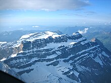
West view of Glärnisch with Glärnischfirn |
||
| height | 2915 m above sea level M. | |
| location | Canton of Glarus , Switzerland | |
| Mountains |
Schwyzer Alps , according to SAC: Glarner Alps |
|
| Dominance | 14.3 km → Hausstock | |
| Notch height | 966 m ↓ Klausenpass | |
| Coordinates | 718 642 / 206 463 | |
|
|
||
| rock | Jurassic & chalk limestone | |
|
Glärnisch group north flank into the Klöntal |
||
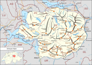
The Glärnisch is a glaciated massif (also known as the Glärnisch group ) to the southwest of Glarus ( Switzerland ) and belongs to the Schwyz Alps . Since it is entirely in the canton of Glarus , it is often said (including by the SAC ) that it is in the Glarus Alps .

geography
The Glärnisch consists of two main ridges , which are arranged in a V-shape and enclose the Glärnischfirn flowing off to the west-south-west . The ridge running to the west to the right of the Glärnischfirn carries the Ruchen ( 2901 m above sea level ) and is bounded in the north by the Klöntal with the Klöntalersee . The ridge that runs to the south-west on the left is slightly higher and carries the Bächistock ( 2915 m above sea level ) and, to the north-east of it, the nameless point ( 2910 m above sea level ) that is now considered the highest point in Glärnisch ( 2910 m above sea level ) above the retreating point Bächistockfirn as well as a point 2914 marked with a cross and marked higher than the Bachstock on the national map until 2013 (until 2013: "2915", while the Bächistock was drawn at 2914.3 meters).
The junction of the ridges (so-called Schwander Ridge) does not represent a summit of its own for most mountaineers, although as a double summit it reaches an autonomy of 60 to 80 meters. The Schwander ridge is climbed as access to the most climbed summit, the Vrenelisgärtli ( 2904 m above sea level , with a prominent, formerly permanent firn field visible from the lowlands ) in front of it to the northeast towards Glarus .
Below the almost horizontal and easily accessible connecting ridge between Bächistock and Vrenelisgärtli (WS) there are also several firn fields in the south-east face. a. the Bächifirn and the Guppenfirn, which run on ribbons across the entire flank and give the Glärnisch its characteristic appearance from the east, in front of the Guppenfirn is the summit of the Nidfurner Tower . On the south-eastern slope of the mountain range lie in two basins the Oberblegisee ( 1422 m above sea level ) and the Guppensee ( 1515 m above sea level ), both without surface drainage.
The Glärnisch also plunges north into the Klöntal with z. Sometimes very steep rock faces.
The Glärnisch in the broader sense also includes the Vorderglärnisch ( 2327 m above sea level , northeast of the Vrenelisgärtli), which rises directly above the canton capital Glarus, and the wheel ( 2661 m above sea level ), which connects to the south-western Bös Fulen conveyed.
geology
The Glärnisch consists of limestones from the Jurassic and Cretaceous periods and belongs to the Helvetic period .
rise
The normal ascent route, which can also be used as a ski tour, leads through the Rossmatter valley to the Glärnischhütte of the Swiss Alpine Club on the west-southwest flank of the mountain ( 1990 m above sea level ) and then on over the Glärnischfirn. All three main peaks can be reached from here, the easiest being the Ruchen (L or T 4, but firn); Vrenelisgärtli and Bächistock (WS) are somewhat more demanding. The direct ascent from Glarus via Oberstafel and the so-called Guppengrat to the Vrenelisgärtli (WS or T 6) is almost classic.
Vrenelisgärtli legend
The mentioned firn field at the Vrenelisgärtli is the place where, according to legend, the Vreneli (little Verena) wanted to create a garden long ago. The plantation up there was a temptation of God, and so it began to snow heavily as a punishment, and the Vreneli and the bowl with which it tried to protect itself against the snow, was snowed in and has stayed up there ever since. The legend is obviously a reaction to the cooling of the temperatures in Central Europe from around 1300, when a climate that was warmer than today was replaced in several phases by a considerably colder one (“ Little Ice Age ”). Incidentally, the firn field melted completely in the summer of 2003, but no remains of the Vreneli or its boiler have been found ...
Literary reception
The Glärnisch is already mentioned in literature by Friedrich Schiller in the fourth act, third scene, by Wilhelm Tell .
Eponyms
The asteroid (2914) Glärnisch , discovered on September 19, 1965, has borne the name of the mountain range since 1992.
literature
- Emil Zopfi (Ed.): Glärnisch - Roses on Vrenelis Gärtli. (Mountain monograph 9), AS Verlag, Zurich 2003, ISBN 9783905111873
- Tim Krohn : Vrenelis Gärtli . Novel. Eichborn, Frankfurt am Main 2007; Diogenes, Zurich 2010, ISBN 978-3-257-23962-1
Web links
Individual evidence
- ↑ a b Maps of Switzerland (SwissTopo)
- ^ A b Ernst Höhne: Knaur's Lexicon for Mountain Friends / The Alps between Matterhorn and Lake Constance . Droemer Knaur, Munich 1987, ISBN 3-426-26223-1 , p. 36 & 120 .
- ↑ a b Johannes Führer: Bergwelt . Munich 1980, p. 38 ff .
- ↑ Minor Planet Circ. 21129


