
Glärnischfirn
The Glärnischfirn (sometimes also Glärnisch Glacier ) is a 2 km long and up to 1 km wide glacier in the Schwyz Alps in the Swiss canton of Glarus .
The glacier is located on the northwest side of the Glärnisch massif (also Glärnisch group ) between 2300 and 2800 meters and runs slightly progressively uphill from west to east.
The normal route to most of the Glärnisch peaks (e.g. the Vrenelisgärtli ) leads over the firn to its eastern end with the Schwandengrat. On this eastern edge it goes 2000 meters almost vertically down to the Klöntalersee .
In recent years the glacier has lost massive amounts of volume and the tongue has already retreated quite a bit.
On the southeast side of the Glärnisch there are two smaller glaciers, the Bächifirn and the Guppenfirn, neither of which are connected to the Glärnischfirn.
location
 |
Location of the glacier in the mountain range.
According to the classification of the Swiss Alpine Club (SAC), the Glärnisch massif is located in the Glarner Alps .
photos
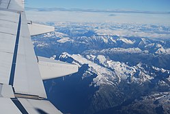
The Glärnischfirn from the air, October 3, 2010

The tongue of the Glärnischfirn 2007
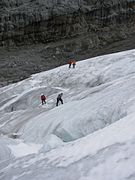
Mountaineers on the glacier 2007
_509.JPG)


supporting documents
- ↑ Location in maps of Switzerland (SwissTopo)
- ^ A b Ernst Höhne: Knaur's Lexicon for Mountain Friends / The Alps between Matterhorn and Lake Constance . Droemer Knaur, Munich 1987, ISBN 3-426-26223-1 , p. 120 .
Coordinates: 47 ° 0 ′ 11 " N , 8 ° 59 ′ 35" E ; CH1903: 718.2 thousand / 206949