Wickedly foul
| Wickedly foul | ||
|---|---|---|
|
Northern flank of Evil Fulen |
||
| height | 2801 m above sea level M. | |
| location | Glarus / Schwyz border , Switzerland | |
| Dominance | 4.29 km → Bächistock | |
| Notch height | 376 m ↓ Gassenfurggel | |
| Coordinates | 714 696 / 202895 | |
|
|
||
| particularities | highest point in the canton of Schwyz | |
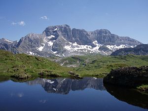
The Bös Fulen , also called Böser Faulen , is 2801 m above sea level. M. the highest mountain peak in the canton of Schwyz . The summit is divided by the border between the Swiss cantons of Glarus and Schwyz.
location
The canton border runs from the summit in a north-west direction and along the ridge for around 450 m in a north-east direction. In the opposite direction, the ridge extends towards the southwest. The northeastern Grisset at 2721 m above sea level. M. is just under a kilometer from Bös Fulen and also bears the unofficial name Guet Fulen .
It is a rocky and impassable mountain range in the Swiss Alps . Since the summit is difficult to reach even for experienced mountaineers, they sometimes mockingly say that the mountain is really "bad".
Adjacent area
Bös Fulen is in the north from Hinter Gassenstock , in the east from the scree slope Gross Risi, in the south from Fulenplänggeli , a rock face approx. 1.5 km away, and in the west from Schafstöckli ( 2303 m above sea level ) and from the Schafbüchel ( 2152 m above sea level ).
Web links


