Lake Naret
| Lake Naret | |||||||||
|---|---|---|---|---|---|---|---|---|---|
|
Lago del Narèt seen from the hiking trail along the north bank. View to the east |
|||||||||
|
|||||||||
|
|
|||||||||
| Coordinates | 686 798 / 147947 | ||||||||
| Data on the structure | |||||||||
| Operator: | Officine idroelettriche della Maggia SA | ||||||||
| Data on the reservoir | |||||||||
| Altitude (at congestion destination ) | 2310 m above sea level M. | ||||||||
| Water surface | 73.4 ha | ||||||||
| Reservoir length | 1.1 km | ||||||||
| Reservoir width | 820 m | ||||||||
| Catchment area | direct: 4.05 km² indirect: 6.02 km² |
||||||||
| Design flood : | 15 m³ / s | ||||||||
| Particularities: |
two dams |
||||||||
| Swell: | |||||||||
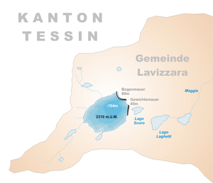
The Lago del Narèt is an artificial lake in the Swiss canton of Ticino in the municipality Lavizzara , the end of the 1960s by the Maggia power plants was created.
location
The lake is at the back of the Val Sambuco and was created by the damming of the still very young Maggia by means of the two dams Narèt I and Narèt II. The nearest town is Fusio . The target of the lake is located at 2310 m above sea level. M. . In the vicinity there are several small mountain lakes that drain into the Lago del Narèt. These include the Lago del Corbo and the Lago di Val Sabbia. Lake Scuro is located below the Narèt II dam.
Access road
The access to the Lago del Narèt is possible via a 14.2 km long road that starts at Fusio. Access to the street is regulated by barriers that are opened in summer according to the passability of the street. After the first barrier at Fusio, the road winds up on the eastern side of the valley to the Lago del Sambuco . The second barrier is at the dam wall, after which the road narrows to a width of 2.8 m. Although it is partly in bad condition, it can also be driven on with motor vehicles at a suitable speed. First it leads along the east bank of the reservoir to the northern end of the lake, where it begins to rise moderately. After about 6 km another barrier is reached at Alp Grasso di Dentro, which may still be closed in June. From there, the somewhat wider road winds up to the two dam walls of Lago del Narèt, which are located above the tree line . With the road consortium, the passability of the road is evident.
Both dams of the Lago del Narèt are passable. Towards the end of the access road, the entrance to the Narèt II dam branches off to the left. On the other side of the dam there is a gravel park area that is often used as a starting point for hikes to the Cristallinahütte , in Italian Capanna Cristallina . The 6.5 hour ascent from Fusio can be shortened to 2.5 hours.
The access road leads directly over the Narèt I dam to the north, at the other end of which there is also a small park area, where excellent hiking trails begin, such as the half-hour hike up to the Passo del Narèt or another two hours to the Christallina hut.
function
The Lago del Narèt is used by the Maggia power plants to store water that accumulates in summer from precipitation and snowmelt in the area, so that it can be used for energy production in winter. The direct catchment area of the lake is 4.05 km². The lake is connected to Lago dei Cavagnöö by an underground pressure tunnel seven kilometers long , to which Lago Sfundau is also connected. These two lakes thus form an additional indirect catchment area of 6.02 km² for Lago del Narèt. In addition, water is pumped up into the lakes from the Robièi headquarters from the Lago di Robièi compensation basin . This center in turn processes the water from the three lakes.
A quantity of water can be stored in Lago del Narèt, from which 150 million kWh of electricity can be generated. The energy conversion takes place in the central Robièi, Bavona, Cavergno and Verbano until the water is transferred to Lake Maggiore . Because of the great gradient between the lake level at 2300 m above sea level. M. and Lake Maggiore at 193 m above sea level. M. measured by the content of the lake, a lot of energy can be obtained, which gives the lake an energy equivalent of 4.75 kWh per cubic meter of lake content .
Technical data of the dams
| Naret I | Naret II | |
|---|---|---|
| Completion: | 1969 | 1969 |
| Lock type: | Arch dam | Gravity dam |
| Crown length: | 435 m | 260 m |
| Height: | 80 m | 45 m |
| Lock volume: | 303,000 m³ | 69,000 m³ |
Swell:
Web links
- Andrea Baumer: Diga Naret 1 . Ed .: Swiss Dam Committee. ( swissdams.ch [PDF]).
- Lago del Narèt on schweizersee.ch
- Lago del Naret on hikr.org/dir
Individual evidence
- ↑ a b c Geoserver of the Swiss Federal Administration ( information )
- ↑ a b c Andrea Baumer: Diga Narèt .
- ↑ Val Sambuco. In: alpi-ticinesi.ch. Retrieved June 13, 2020 .
- ↑ Fusio-Naret. Consorzi Stradali, accessed June 14, 2020 .
- ↑ From Lago del Naret. SAC, accessed on June 14, 2020 (Swiss Standard German).
- ↑ Ofima (ed.): Ofima, an exciting challenge . Operator's brochure. S. 117 ( ofima.ch [PDF]).
- ↑ List of barrages suisses. In: swissdams.ch. Swiss Dam Committee, accessed on June 14, 2020 .


