
Maggia (river)


| ||
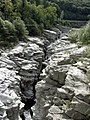
Source and mouth of the Maggia
|
The Maggia is a 60 km long river in the Swiss canton of Ticino . It flows through the Val Sambuco , the Val Lavizzara and the Valle Maggia and flows into Lake Maggiore near Locarno in a delta . In doing so, it drains a large part of the Ticino Alps .
The Maggia power plants use the hydropower of the Maggia at 5 reservoirs to generate electrical energy. The annual average is 144 MW generated with the water of the Maggia .
course
The Maggia rises at about 2480 m above sea level. M. in debris on the eastern slope of the Cristallina . The stream is only visible in its basin in the Sasso del Corbo area . It initially flows northeast and crosses the Lago del Corbo and the reservoir Lago del Narèt . It turns in an arc to the southeast and reaches the Val Sambuco , where it is dammed to the Lago del Sambuco . At Fusio it leaves the reservoir and now flows through the Val Lavizzara towards the southwest. The Maggia passes Mogno and overcomes a valley step at Corgello (also Corsgell ' ). In Peccia which opens from right Peccia from the Valle di Peccia . The villages of Prato-Sornico , Broglio , Menzonio and Brontallo follow .
Between Cavergno and Bignasco , the Val Lavizzara joins the Bavona valley to form the Maggia valley. From the right it takes the Bavona and shortly afterwards the Rovana at Cevio . It passes Someo , Maggia and Gordevio , where the valley narrows. After Avegno , it leaves the valley through a narrow gorge and reaches the Terre di Pedemonte at Ponte Brolla . The Maggia joins the Melezza from the right and finally flows through Locarno at 193 m above sea level. M. in Lake Maggiore.
Special
A special feature of the Maggia is the waterfall, which flows from the Maggia just before Ponte Brolla a few hundred meters after leaving Avegno in the granite gorge under a footbridge. When the water level is low, the water falls from a height of about four meters into a pot that is a good five meters in diameter and four meters deep, before flowing through the aforementioned gorge to a kind of lake about 15 meters deep.
At normal times, the Maggia near Ponte Brolla carries around 2 cubic meters of water per second. At high water, however, it is 5000 cubic meters; as much as the Rhine leads near Basel.
Sports
Every year, international high diving competitions are held in which the participants jump from a platform over 20 meters into the depth.
Below Ponte Brolla there is a dive site that is suitable for river diving . The Maggia is there between five and ten meters deep and has a spectacular rocky landscape below the surface of the water. The crystal clear water usually offers greater visibility than tropical waters.
hazards
Entering the partially dry river bed of the Maggia can be dangerous. Depending on the weather or through sudden water drainage at the reservoirs in the headwaters of the Maggia, the water level can rise extremely quickly within a short period of time, making the Maggia a raging river. There have been several fatal drowning accidents.
Even if the water level suddenly swells after snowmelt or after violent thunderstorms at higher altitudes, a dangerous situation can arise: Jumpers who do not plunge into the outflow direction of the pot at the waterfall are pressed against the rock by the force of the water and drown. Despite warnings, deaths occur again and again.
Picture gallery

Young Maggia below the Naret reservoir in Val Lavizzara (summer 2009)

Maggia between Giumaglio and Someo (summer 2011)

The Maggia near Lodano
Maggia near Ponte Brolla

Maggia Delta between Locarno and Ascona


literature
- Martino Signorelli: Storia della Valmaggia. Tipografia Stazione SA, Locarno 1972, pp. 7, 102, 108, 171, 174, 180, 190, 231, 242, 250, 254, 255-256, 258, 410.
- Daniela Pauli Falconi: Maggia (river). In: Historical Lexicon of Switzerland .
Web links
- Vallemaggia Turismo
- Maggia (river) on the ETHorama platform
- Report on an inspection
- Water level in Solduno
- Water level in Bignasco
- The waters of the Maggia , Swiss film weekly show from August 25, 1950
Individual evidence
- ↑ a b Geoserver of the Swiss Federal Administration ( information )
- ↑ Evaluations of the water network. (XLSX) (No longer available online.) FOEN , December 2013, archived from the original on June 13, 2018 ; Retrieved on August 9, 2017 (listing of Swiss rivers> 30km). Info: The archive link was inserted automatically and has not yet been checked. Please check the original and archive link according to the instructions and then remove this notice.
- ↑ Modeled mean annual discharge. In: Topographical catchment areas of Swiss waters: sub-catchment areas 2 km². Retrieved August 12, 2017 .
- ↑ Locarno Solduno measuring station 1985–2016 (PDF) Federal Office for the Environment FOEN
- ↑ Delta della Maggia on ethorama.library.ethz.ch/de/node
- ^ Villages on the way into the abyss Neue Zürcher Zeitung, August 18, 2002
- ↑ Part II: Valle Maggia - Fluss Maggia , 200bar.de, accessed: June 12, 2011
Rivers with a total length of more than 30 km:
Aare |
Albula |
Allaine |
Old Rhine |
Arbogne |
Areuse |
Swiss stone pine |
Birs |
Brenno |
Broye |
Calancasca |
Doubs |
Drance de Bagnes |
Thinning |
Emme |
Engelberger Aa |
Ergolz |
Glâne |
Smooth |
Glenner (Glogn) |
Hinterrhein |
Inn (En) |
Julia (Gelgia) |
Kander |
Little Emme |
Landquart |
Land water |
Langete |
Limmat |
Linth |
Lorze |
Maggia |
Mentue |
Moësa |
Muota |
Murg |
Necker |
Orbe |
Petite Glâne |
Plessur |
Rabiusa |
Reuss |
Rhine |
Rhone |
Saane |
Schüss (Suze) |
Seez |
Scythe |
Sihl |
Simme |
Sitter |
Sorne |
Suhre |
Talent |
Tamina |
Ticino (Ticino) |
Thur |
Töss |
Venoge |
Verzasca |
Vispa |
Vorderrhein |
Wigger |
Wyna