
Bavona
| Bavona | ||
 |
||
| Data | ||
| Water code | CH : 52 | |
| location | Switzerland | |
| River system | Po | |
| Drain over | Maggia → Ticino → Po → Adriatic Sea | |
| source | on the Cavagnöö glacier ( Ghiacciaio del Cavagnöö ) 46 ° 27 ′ 16 ″ N , 8 ° 29 ′ 9 ″ E |
|
| Source height | 2539 m above sea level M. | |
| muzzle | at Bignasco in the Maggia coordinates: 46 ° 20 ′ 21 ″ N , 8 ° 36 ′ 30 ″ E ; CH1903: 690 063 / 132 645 46 ° 20 '21 " N , 8 ° 36' 30" O |
|
| Mouth height | 432 m above sea level M. | |
| Height difference | 2107 m | |
| Bottom slope | 11% | |
| length | 19.2 km | |
| Catchment area | 121.28 km² | |
| Discharge at the mouth of A Eo : 121.28 km² |
MQ Mq |
6.5 m³ / s 53.6 l / (s km²) |
| Left tributaries | Ri di Larechia | |
| Right tributaries | Ri di Antabia, Calnègia | |
| Flowing lakes | Lago Bianco | |
| Reservoirs flowed through | Lake Cavagnöö | |
| Communities | Cevio | |
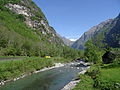
The Bavona is a 19 kilometer long right tributary of the Maggia in the canton of Ticino . It flows through the in the municipality of Cevio lying Valle Bavona , a side valley of the Maggia Valley and dehydrated while an area of around 121 square kilometers.
course
The Bavona rises from a small lake at the edge of the glacier at the end of the Cavagnöö glacier at 2539 m above sea level. M. and only a little later flows into the reservoir Lago dei Cavagnöö . She leaves the lake and crosses Lago Bianco . The river flows in a south-westerly direction and takes in the waters of Lago Nero and Lago di Robiei . After it has taken up the runoff of the Lago del Zött , it enters the Valle Bavona and flows mainly through the forest in a south-easterly direction.
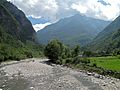
At the first settlement, San Carlo , it takes on the Ri di Antabia from the right, which rises in Lake Antabia . It flows past the hamlets of Sonlerto , Faedo , Fontanellata and Roseto . At Foroglio it receives the Calnègia , its main tributary. It now touches Ritorto , Sabbione , Fontana , Mondada and Cavergno and flows into the Maggia from the right at Bignasco .
at Roseto

.jpg)
Web links
Individual evidence
- ↑ a b Geoserver of the Swiss Federal Administration ( information )
- ^ Hydrological Atlas of Switzerland from the Federal Office for the Environment FOEN
- ↑ a b Modeled mean annual discharge. In: Topographical catchment areas of Swiss waters: sub-catchment areas 2 km². Retrieved August 19, 2017 .