
Calancasca
| Calancasca | ||
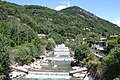
 The calancasca near Cauco |
||
| Data | ||
| Water code | CH : 58 | |
| location | Canton of Graubünden ; Switzerland | |
| River system | Po | |
| Drain over | Moësa → Ticino → Po → Adriatic Sea | |
| source | on the southern slope of the Zapporthorn 46 ° 28 ′ 36 ″ N , 9 ° 6 ′ 39 ″ E |
|
| Source height | approx. 2840 m above sea level M. | |
| muzzle | a little above Roveredo in the Moësa coordinates: 46 ° 14 ′ 12 " N , 9 ° 8 ′ 27" E ; CH1903: 731 292 / 122017 46 ° 14 '12 " N , 9 ° 8' 27" O |
|
| Mouth height | 298 m above sea level M. | |
| Height difference | approx. 2542 m | |
| Bottom slope | approx. 82 ‰ | |
| length | 31 km | |
| Catchment area | 140.97 km² | |
| Discharge at the estuary A Eo gauge: 140.97 km² |
MQ Mq |
7.23 m³ / s 51.3 l / (s km²) |
| Left tributaries | Riale Passit, Ria di Ri, Ria del Frott, Riale de la Motta, Riale Auriglia | |
| Right tributaries | Ria de Remolasch, Ria de Campalesc, Ria de Rode, Ria Pian, Ria di Arvigo, Riale di Buseno | |
| Reservoirs flowed through | Molina reservoir | |
| Communities | Mesocco , Rossa , Calanca , Buseno , Castaneda , Grono , Roveredo | |

| ||
Source and mouth of the Calancasca
|
The Calancasca is a 31 kilometer long white water river in the canton of Graubünden .
It rises south of the Zapporthorn at an altitude of around 2840 meters. It flows south through the Calanca valley and flows into the Moësa after 31 kilometers at Roveredo . At Buseno , the river to the Molina reservoir is dammed and the water drained. Only the residual amount of water remains below the reservoir .
At Grono, before the confluence with the Moësa


Web links
- River description for water trips
- Federal Office for the Environment, hydrological data of the Calancasca in Buseno
Individual evidence
- ↑ a b Geoserver of the Swiss Federal Administration ( information )
- ↑ Evaluations of the water network. (XLSX) FOEN , December 2013, accessed on August 9, 2017 (listing of Swiss rivers> 30km).
- ↑ a b Modeled mean annual discharge. In: Topographical catchment areas of Swiss waters: sub-catchment areas 2 km². Retrieved August 9, 2017 .
Rivers with a total length of more than 30 km:
Aare |
Albula |
Allaine |
Old Rhine |
Arbogne |
Areuse |
Swiss stone pine |
Birs |
Brenno |
Broye |
Calancasca |
Doubs |
Drance de Bagnes |
Thinning |
Emme |
Engelberger Aa |
Ergolz |
Glâne |
Smooth |
Glenner (Glogn) |
Hinterrhein |
Inn (En) |
Julia (Gelgia) |
Kander |
Little Emme |
Landquart |
Land water |
Langete |
Limmat |
Linth |
Lorze |
Maggia |
Mentue |
Moësa |
Muota |
Murg |
Necker |
Orbe |
Petite Glâne |
Plessur |
Rabiusa |
Reuss |
Rhine |
Rhone |
Saane |
Schüss (Suze) |
Seez |
Scythe |
Sihl |
Simme |
Sitter |
Sorne |
Suhre |
Talent |
Tamina |
Ticino (Ticino) |
Thur |
Töss |
Venoge |
Verzasca |
Vispa |
Vorderrhein |
Wigger |
Wyna