Selma GR
| GR is the abbreviation for the canton of Graubünden in Switzerland and is used to avoid confusion with other entries of the name Selma . |
| Selma | ||
|---|---|---|
| State : |
|
|
| Canton : |
|
|
| Region : | Moesa | |
| Political community : | Calanca | |
| Postal code : | 6545 | |
| former BFS no. : | 3811 | |
| Coordinates : | 729 241 / 130854 | |
| Height : | 977 m above sea level M. | |
| Area : | 2.91 km² | |
| Residents: | 29 (December 31, 2014) | |
| Population density : | 10 inhabitants per km² | |
| Website: | www.comunedicalanca.ch | |
|
Selma GR |
||
| map | ||
|
|
||
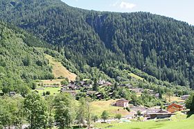
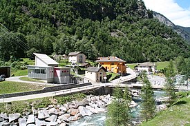
Selma is a village in the municipality of Calanca , which lies in the former Calanca district in the Moesa district of the canton of Graubünden in Switzerland . The village is located in the Calanca valley, a side valley of the Misox .
geography
The village is at an altitude of 977 m above sea level. M. on the left bank of the Calancasca and at the west foot of the Piz de Groven (2694 m above sea level), 13 kilometers north of the Grono and 25 kilometers north of the Bellinzona station of the Swiss Federal Railways .
history
The village was first mentioned in 1582 under the then name Selma. In 1656 Selma bought part of Alp Trescolmen (Trescolmine) for 3000 lire.
coat of arms
In green, a heraldic golden key placed obliquely to the left with a key bit turned to the left, accompanied by two golden shells . The motifs of the coat of arms in the colors of the Trivulzio stand for the double patronage of the parish church . The key represents St. Peter , while the shells symbolize St. James the Elder .
Community merger
Until December 31, 2014 Selma was a separate political municipality . On January 1, 2015, it merged with the municipalities of Arvigo , Braggio and Cauco to form the new municipality of Calanca .
population
| Population development | ||||||||||||
|---|---|---|---|---|---|---|---|---|---|---|---|---|
| year | 1683 | 1733 | 1830 | 1850 | 1900 | 1950 | 1970 | 1990 | 2000 | 2003 | 2007 | 2014 |
| Residents | 300 | 200 | 93 | 73 | 71 | 60 | 34 | 31 | 44 | 44 | 39 | 29 |
The former municipality had 44 inhabitants in 2003 and 39 in 2007, but still wanted to remain independent for a long time.
Attractions
- Catholic parish church of SS. Giacomo e Pietro (rebuilt 1662–1667 by Giovanni Maria Regesono in Baroque style )
economy
There is no village shop in Selma, but a hostel for holiday camps and a restaurant. A cable car runs in automatic 24-hour operation to Landarenca , which can be reached on foot in 40 minutes on a mule track .
literature
- Simona Martinoli and others: Guida d'arte della Svizzera italiana. Edizioni Casagrande, Bellinzona 2007, pp. 518-519.
- Erwin Poeschel : The art monuments of the canton of Graubünden. Volume VI: The Italian Grisons valleys Puschlav, Misox and Calanca (= Swiss art monuments. Volume 17). Edited by the Society for Swiss Art History GSK. Birkhäuser, Bern 1945, DNB 367611058 ; unchangeable Nachdr., [2. Ed.], Ibid. 1975, ISBN 3-7643-0807-9 .
- Balser Puorger : Selma. In: Historical-Biographical Lexicon of Switzerland . Volume 6: Schultheiss - Sisgau. Attinger, Neuenburg 1921, p. 336 ( PDF; 27.1 MB; PDF-p. 87 ).
- Cesare Santi: Selma. In: Historical Lexicon of Switzerland . 15th December 2016 .
- Various authors: Leggia. In: Storia dei Grigioni , 3 volumes, Collana "Storia dei Grigioni", Edizioni Casagrande, Bellinzona 2000.
Web links
- Comune di Calanca Official website of the municipality (Italian language)
- Selma on elexikon.ch
Individual evidence
- ↑ Cesare Santi: Selma. In: Historical Lexicon of Switzerland . 15th December 2016 .
- ^ Cantonal library of Graubünden: Catholic parish church SS. Giacomo e Pietro. In: graubuendenkultur.ch. Retrieved on October 13, 2016 (Source: Jürg Davatz et al .: Art guide through Switzerland. Volume 2: Glarus, Graubünden, Nidwalden, Obwalden, Schwyz, Ticino, Uri. Text ed .: Steffan Biffiger. Ed. by the Society for Swiss Art History. Bern 2005, ISBN 3-906131-96-3 ).


