Verdabbio
| Verdabbio | ||
|---|---|---|
| State : |
|
|
| Canton : |
|
|
| Region : | Moesa | |
| Political community : | Grono | |
| Postal code : | 6538 | |
| former BFS no. : | 3836 | |
| Coordinates : | 732 487 / 125559 | |
| Height : | 604 m above sea level M. | |
| Area : | 13.13 km² | |
| Residents: | 163 (December 31, 2015) | |
| Population density : | 12 inhabitants per km² | |
| Website: | www.grono.ch | |
| map | ||
|
|
||
Until December 31, 2016, Verdabbio was a municipality in the Moesa region of the canton of Graubünden in Switzerland .
geography
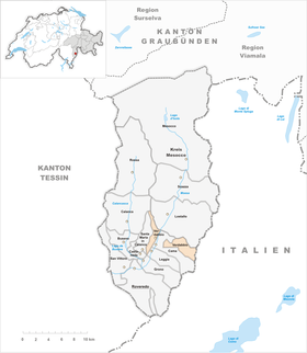
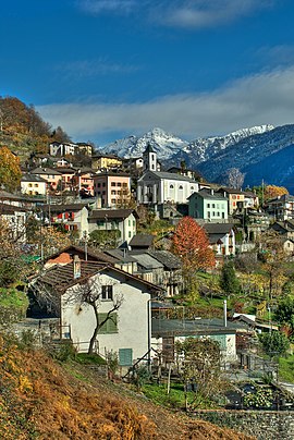
The community is located on a terrace between the Ria di Val di Cama and the Piz Duna on the right side of the Misox around 300 meters above the valley floor. The hamlet of Valdort (509 m above sea level) lies to the east below the village. Another district is Piano di Verdabbio (370 m above sea level), which is one and a half kilometers northeast of the village in the valley floor west of the Moësa . A large part of the Val di Cama , a left side valley of the Misox , also belongs to the municipality . The eastern border of Verdabbio is also the national border with Italy .
Of the entire municipal area of 1,311 ha, 814 ha (= 62.1%) are forested and 418 ha (= 31.9%) are mountain. Just 64 hectares are agriculturally usable and fifteen hectares are settlement areas.
history
The village was first mentioned in 1203 under the then name Vertabio . The village belonged to the 2nd Squadra of the Court of Roveredo GR , which together with Misox and Calanca formed a high court of the Upper Confederation . In Bellinzona in 1524 it buys away from every tithe obligation to Franz von Sacco-Norantola, as well as from the tithe rights of Giacomo de Sacco in Roveredo in 1561. Since 1851 the parish has been part of the Roveredo County.
coat of arms
Blazon : In red a fallen golden (yellow) tip, covered with a blue grape
The overturned point in the colors of the Barons von Sax stands for the first letter of the community name, while the grape refers to viticulture.
Community merger
On January 1, 2017 , Verdabbio merged with the municipality of Leggia to form the new municipality of Grono .
population
| Population development | |||||||
|---|---|---|---|---|---|---|---|
| year | 1802 | 1850 | 1900 | 1950 | 2000 | 2004 | 2015 |
| Residents | 145 | 198 | 185 | 177 | 164 | 163 | 163 |
The population speaks an Italian dialect. In the 19th century, numerous residents emigrated to California, Australia and Belgium. Of the 163 residents at the end of 2004, 145 (= 88.96%) were Swiss citizens.
traffic
The community is connected to the public transport network by the Grono-Verdabbio post bus line .
Attractions
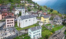
The three churches of the parish are the most interesting buildings in the area:
- the parish church of San Pietro, which was built in 1631 in baroque style and rests on an older foundation
- the prayer chapel of Santa Madonna Addolorata from the same century
- the church of Santa Maria Immacolata in the district of Valdort
Also worth seeing are:
- a farmhouse
- a shell stone called Asccitt (cut) in the district of Al Pian dèla Conca (695 m above sea level)
- a cup stone called El sass de Natal
literature
- Franco Binda: Il mistero delle incisioni. Armando Dadò editore, Locarno 2013, ISBN 978-88-8281-353-6 .
- The municipalities of the canton of Graubünden. Chur / Zurich, 2003, ISBN 3-7253-0741-5 .
- Paul Gillardon: Verdabbio. In: Historisch-Biographisches Lexikon der Schweiz , Volume 7, Ungelt - Villarvolard. Attinger, Neuchâtel 1921, p. 221 ( digitized version ).
- Simona Martinoli and others: Guida d'arte della Svizzera italiana. Published by the Society for Swiss Art History , Edizioni Casagrande, Bellinzona 2007, ISBN 978-88-7713-482-0 , p. 504.
- Erwin Poeschel : The Art Monuments of the Canton of Graubünden, Volume VI: The Italian Graubünden valleys of Puschlav, Misox and Calanca. (= Art Monuments of Switzerland. Volume 17). Edited by the Society for Swiss Art History GSK. Bern 1945, ISBN 978-3-906131-55-9 .
- Cesare Santi: Verdabbio. In: Historical Lexicon of Switzerland . 22nd June 2017 .
- Various authors: Buseno. In: Storia dei Grigioni , 3 volumes, Collana "Storia dei Grigioni", Edizioni Casagrande, Bellinzona 2000.
Web links
- Website of the municipality of Grono
- Site of the former municipality of Verdabbio
- Website of the Italian-speaking municipalities of Graubünden (in Italian)
Individual evidence
- ↑ Cesare Santi: Verdabbio. In: Historical Lexicon of Switzerland . 22nd June 2017 .
- ↑ a b c d Simona Martinoli and others: Guida d'arte della Svizzera italiana. Bellinzona 2007, p. 504.
- ^ Catholic parish church of San Pietro
- ↑ Franco Binda, Locarno 2013, pp. 228-229.
- ^ Franco Binda, Locarno 2013, p. 19.


