
Thur (Rhine)


| ||
Source and mouth of the Thur
|
The Thur is an approximately 135 km long left tributary of the Rhine . It is the second longest river in eastern Switzerland after the Rhine .
Surname
The name Thur is derived from the Indo-European word dhu ("the hurrying one"). The canton of Thurgau is named after the body of water .
Data
The Thur has a total length of 134.6 km from the source of the Säntisthur to the confluence with the Rhine. Of these, 68 kilometers are in the canton of St. Gallen , 42 kilometers in the canton of Thurgau and 19 kilometers in the canton of Zurich . Its catchment area has an area of around 1760 km².
geography
course
overview
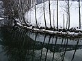
The source of the Säntisthur is on the Chalbersäntis above Unterwasser in the Toggenburg . After two waterfalls, the Thurfällen in wooded Chämmerlitobel, the Säntisthur in underwater united with the Wildhauser Thur and flows as Thur through the Toggenburg (see map: Map ).
In Lütisburg opens Necker in the Thur. From Wil SG the Thur flows east. At Oberbüren , where the Glatt flows into the Thur, it leaves the Toggenburg region and continues to flow in a north-easterly direction into the canton of Thurgau . In Bischofszell the Sitter flows into the Thur, which from then on flows further northwest. In Frauenfeld which opens Murg in the Thur. The Thur reaches the Rhine near Flaach and Ellikon am Rhein.
As far as Kradolf , the Thur runs in a rock bed, after which the river bed consists of debris from the river and glacial deposits from the Säntis glacier.
River sections
Thurquelle – Wattwil
The source of the Thur is in Trosen . Then it flows through Unterwasser , where the Wildhauser Thur joins, to Alt St. Johann and from there to Starkenbach , where the Neuenalpbach and the Leistbach join . In Müli in stone which leads Wissthur one after the Chlusbach in ensign has accrued. In the center of Nesslau , the Luteren flows into the Thur, before the Lütisbach flows into Krummenau one village further . The Steintaler Bach , Stelzbach and shortly thereafter the Mettlenbach flow into Ebnat-Kappel , and at the Rickenpass shortly before Wattwil the Rickenbach joins, then the Feldbach.
Wattwil – Schwarzenbach
In Krinau after Lichtensteig the Krinaubach is added. A little later, in the center of Dietfurt (municipality of Bütschwil-Ganterschwil ), the Taabach flows into it . Shortly afterwards the Tobelackerbach flows into the Thur. Without any other large estuaries, it goes to Lütisburg , where the Necker flows into it.
Schwarzenbach-Weinfelden
Without large tributaries, but with a large curve, it goes via Schwarzenbach near Wil to Niederuzwil , where the Uze joins. Immediately afterwards the Glatt flows into Oberbüren . In Bischofszell the river bed almost turns around while the Sitter flows in. The Rütibach flows into the vicinity of Bürglen , and the Giessen flows into one municipality further, in Weinfelden .
Weinfelden – Rhine estuary
Then it goes to Pfyn , where the inland canal and the Chemenbach flow. When you finally arrive in Frauenfeld , the Murg flows into the Thur. In Thalheim , the left-Thur single channel flows with the Tägelbach and Ellikerbach to. Then it flows through Andelfingen . The Niderwisenbach flows into it shortly after the Thur has flowed past Wäspersbüel and shortly before it flows into the Rhine .
Catchment area
The Thur's catchment area is 1759.58 km² and consists of 29.1% wooded area , 58.6% agricultural area and 9.4% settlement area .
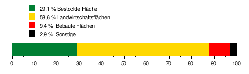
The mean height of the catchment area is 755 m above sea level. M. , the minimum height is 343 m above sea level. M. and the maximum height at 2501 m above sea level. M.
Tributaries
- Wissthur (near stone )
- Luteren (near Neu St. Johann )
- Dietfurterbach (near Dietfurt )
- Necker (near Lütisburg )
- Gonzenbach (near Lütisburg)
-
Uze (near Niederuzwil )
- For tributaries see Uze
-
Smooth (near Oberbüren )
- For tributaries see Glatt
- Sitter (near Bischofszell )
- Giessen (near Amlikon-Bissegg )
- Kemme (near Pfyn )
- Seebach (near Weiningen )
- Murg
Flood
The course of the Thur is not balanced by a lake. From the source to the confluence with the Rhine, it therefore remains a torrent which, depending on the weather and climate, tends to flood very quickly.
Andelfingen measuring point
The mean annual flood of the Thur is 588.52 m³ / s. The highest annual peak ever recorded was measured in 1999 and was 1130 m³ / s.
The table of flood probabilities for the Thur at the last measuring point before the confluence with the Rhine.
| Annuality (years) | 2 | 5 | 20th | 30th | 50 | 100 |
|---|---|---|---|---|---|---|
| Discharge (m³ / s) | 572 | 727 | 819 | 943 | 996 | 1065 |
| Note to HQN: the number corresponding to the high water flow (HQ = H ochwasser q uantität) in m³ / s, which - repeated with the specified return period (n = number of years) - the average. | ||||||
Further measuring points
The BfU measuring point network records the following additional measuring points for the Thur:
- Thur - Halden
- Thur - Jonschwil, Mühlau
Fish death
Since 2015 there has been a fish death every summer below Bütschwil , in which 80 to 90 percent of the young fish population of the brown trout have died. In 2019, all of the dead animals showed inflammation of the liver and heart, and ultimately died of heart failure . The cause for this has not yet been found.
bridges
On its way, the Thur is spanned by over 100 bridges, the most important of which are the covered wooden bridges in Lütisburg, Bischofszell , Eschikofen and Andelfingen , the railway bridges in Ossingen and Andelfingen and the two Weinland road bridges near Andelfingen.
Power plants
Thurweg
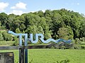
The Thurweg (regional hiking route No. 24 from Wanderland Schweiz ) is a 160 kilometer long hiking trail and leads along the banks of the Thur from Wildhaus to Rüdlingen . The green valley of the Thur offers a wealth of variety, be it in the landscape, in the villages or on the bridges that cross the Thur.
photos

The Säntisthur near Laui in front of the Thur falls

The Thurffalls at Unterwasser SG

at Alt St. Johann
Thur near Starkenbach SG

Mühlau small hydropower plant shortly before completion
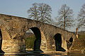
The eight- bay Thur Bridge from 1487 in Bischofszell

The Ossingen Viaduct from 1877 on the Winterthur – Etzwilen railway line

at Flaach
at Warth

The mouth of the river in the Rhine


literature
- Markus Hostmann. 2009. Liberated water: voyages of discovery in revitalized river landscapes in Switzerland. Zurich 2009, Rotpunktverlag
- Heinrich Jung: How the Thur was tamed. In: Thurgauer Jahrbuch , Vol. 49, 1974, pp. 7-24. ( e-periodica.ch )
Web links
- Canton of Thurgau: Thur
- Topographical catchment areas of Swiss waters: Thur
- Hans Büchler: Thur (Rhine). In: Historical Lexicon of Switzerland .
- River description for water trips
- Andelfingen gauge
Individual evidence
- ↑ Geographic information system of the canton of St. Gallen water network 1: 10,000
- ↑ Geoserver of the Swiss Federal Administration ( information )
- ↑ Evaluations of the water network. (XLSX) FOEN , December 2013, accessed on August 9, 2017 (listing of Swiss rivers> 30km).
- ↑ Topographical catchment areas of Swiss waters: sub-catchment areas 2 km². Retrieved July 22, 2018 .
- ↑ Thur - Jonschwil, Mühlau. (PDF) In: Federal Office for the Environment. Retrieved July 22, 2018 .
- ↑ Thur - Halden. (PDF) In: Federal Office for the Environment. Retrieved July 22, 2018 .
- ↑ Thur - Andelfingen. (PDF) In: Federal Office for the Environment. Retrieved July 22, 2018 .
- ↑ Topographic catchment areas of Swiss waters: Thur
- ↑ Flood probabilities (annual flood), Thur - Andelfingen. (PDF) Federal Office for the Environment FOEN, Hydrology Department, accessed on January 29, 2014 .
- ↑ Measuring point: Thur - Andelfingen (2044), on FOEN hydrodata
- ↑ Measuring point: Thur - Halden (2181), on FOEN hydrodata
- ↑ Measuring point: Thur - Jonschwil, Mühlau (2303), on FOEN hydrodata
- ↑ Fish deaths in the Thur - mystery remains unsolved. In: srf.ch . May 18, 2019, accessed May 20, 2019 .
- ↑ Lara Wüest: Fish deaths in the Thur near Bütschwil may remain unsolved - fishermen are disillusioned. In: tagblatt.ch . September 20, 2019, accessed September 21, 2019 .
- ↑ Flyer "Thurweg / Wil-Wattwil-Wildhaus"; 'Cantonal St. Gallen hiking trails', Abtwil, 'Toggenburger Verkehrsverband' and 'Tourismusverband St. Gallerland', St. Gallen
Rivers with a total length of more than 30 km:
Aare |
Albula |
Allaine |
Old Rhine |
Arbogne |
Areuse |
Swiss stone pine |
Birs |
Brenno |
Broye |
Calancasca |
Doubs |
Drance de Bagnes |
Thinning |
Emme |
Engelberger Aa |
Ergolz |
Glâne |
Smooth |
Glenner (Glogn) |
Hinterrhein |
Inn (En) |
Julia (Gelgia) |
Kander |
Little Emme |
Landquart |
Land water |
Langete |
Limmat |
Linth |
Lorze |
Maggia |
Mentue |
Moësa |
Muota |
Murg |
Necker |
Orbe |
Petite Glâne |
Plessur |
Rabiusa |
Reuss |
Rhine |
Rhone |
Saane |
Schüss (Suze) |
Seez |
Scythe |
Sihl |
Simme |
Sitter |
Sorne |
Suhre |
Talent |
Tamina |
Ticino (Ticino) |
Thur |
Töss |
Venoge |
Verzasca |
Vispa |
Vorderrhein |
Wigger |
Wyna