
Weiningen TG
| TG is the abbreviation for the canton of Thurgau in Switzerland and is used to avoid confusion with other entries of the name Weiningen . |
| Weiningen | ||
|---|---|---|
 |
||
| State : |
|
|
| Canton : |
|
|
| District : | Frauenfeld | |
| Political community : | Warth-Weiningen | |
| Postal code : | 8532 | |
| former BFS no. : | 4838 | |
| Coordinates : | 708 956 / 272.04 thousand | |
| Height : | 448 m above sea level M. | |
| Area : | 5.03 km² | |
| Residents: | 677 (December 31, 2018) | |
| Population density : | 135 inhabitants per km² | |
.jpg) Weiningen TG |
||
| map | ||
|
||

Weiningen , in Swiss German Wiininge , is a former municipality and a village in the municipality of Warth-Weiningen in the Frauenfeld district of the canton of Thurgau in Switzerland .
From 1803 to 1994 the local community Weiningen with Nergeten and Weckingen was part of the municipal community Pfyn . On 1 January 1995 merged the local churches Warth and Weiningen to the municipality Warth-Weiningen.
geography
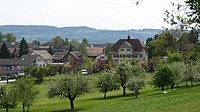
Weiningen is 3 kilometers north of Frauenfeld on a hill between the Seebach and Thur valleys .
history

In 1219 Weiningen is documented as Winingin . From the High Middle Ages until 1798 the place belonged to the Ittingen judiciary .
The Weininger Chapel St. Niklaus was first mentioned in 1486. Weiningen was part of the church in Pfyn until 1992, but was provided by the Catholic priest of Hüttwilen during the Reformation from 1529 to 1567. It has been an independent parish since 1993 .
In addition to cultivating fields, meadows and fruit, Weiningen also cultivated wine until the end of the 19th century, which had to be stopped due to phylloxera . In the 19th century, cattle and dairy farming were added. The place received a cheese dairy in 1883 and a low-stem orchard in 1958. From 1979 to 2000 a goods improvement was carried out. Construction companies, a concrete plant and a carpentry shop are based in Weiningen.
coat of arms

Blazon : In black with a yellow grape with a white stem and two white leaves.
The grape is talking to Weiningen. The colors black and white indicate that it belongs to the jurisdiction of the former Charterhouse
population
| year | 1831 | 1850 | 1900 | 1950 | 1990 | 2000 | 2010 | 2018 |
| Local parish | 305 | 316 | 336 | 343 | 490 | |||
| Locality | 400 | 491 | 677 | |||||
| source | ||||||||
Of the total of 677 inhabitants of the village of Weiningen in 2018, 89 or 13.1% were foreign nationals. 312 (46.1%) were Protestant Reformed and 130 (19.2%) were Roman Catholic.
photos
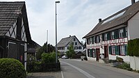
village street
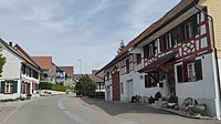
Dorfstrasse, opposite direction
school
.jpg)


Web links
Individual evidence
- ↑ Swiss land use statistics. Completed on July 1, 1912. Published by the Federal Statistical Bureau. ( Memento from April 12, 2016 in the Internet Archive )
- ↑ a b c d Localities and their resident population. Edition 2019 . On the website of the Statistical Office of the Canton of Thurgau (Excel table; 0.1 MB), accessed on April 28, 2020.
- ↑ Weiningen on ortsnames.ch (online database), accessed on February 15, 2020
-
↑ a b c d e
Erich Trösch: Weiningen (TG). In: Historical Lexicon of Switzerland .
These sections are largely based on the entry in the Historical Lexicon of Switzerland (HLS), which, according to the HLS's usage information, is under the Creative Commons license - Attribution - Share under the same conditions 4.0 International (CC BY-SA 4.0). - ↑ a b municipal coat of arms . On the website of the State Archives of the Canton of Thurgau, accessed on December 8, 2019
- ↑ Locations and Settlements Directory. Canton of Thurgau, 2005 edition . On the website of the Statistical Office of the Canton of Thurgau (PDF; 1.7 MB), accessed on April 28, 2020.
- ↑ Locations and Settlements Directory. Canton of Thurgau, 2012 edition. On the website of the Statistical Office of the Canton of Thurgau (PDF; 3.4 MB), accessed on May 11, 2020.
Remarks
- ↑ with outside courtyards
Basadingen-Schlattingen | Berlingen | Diessenhofen | Eschenz | Felben-Wellhausen | Frauenfeld | Gachnang | Herdern | Homburg | Hüttlingen | Hüttwilen | Mammers | Matzingen | Muellheim | Nine-shape | Pfyn | Schlatt | Steckborn | Stettfurt | Thundorf | Uesslingen book | Wagenhausen | Warth-Weiningen
Former municipalities: Basadingen | Book near Frauenfeld | Dettighofen | Eschikofen | Fahrhof | Felben | Gerlikon | Gündelhart-Hörhausen | Harenwilen | Herten | Horgenbach | Huben | Islikon | Kaltenbach | Kefikon | Kurzdorf | Langdorf | Langenhart | Lance neunforn | Lustdorf | Mett-Oberschlatt | Mettendorf | Niederneunforn | Niederwil | Walnut trees | Oberneunforn | Oberwil | Rheinklingen | Salen-Reutenen | Schlattingen | Uerschhausen | Uesslingen | Subdivision | Warth | Weiningen | Wellhausen | Wetzikon | Wilen bei Neunforn | Willisdorf
Canton of Thurgau | Districts of the Canton of Thurgau | Municipalities of the Canton of Thurgau