
Lance neunforn
| Lance neunforn | ||
|---|---|---|
 |
||
| State : |
|
|
| Canton : |
|
|
| District : | Frauenfeld | |
| Political community : | Herdern | |
| Postal code : | 8506 | |
| former BFS no. : | 4812 | |
| Coordinates : | 712 855 / 275 894 | |
| Height : | 562 m above sea level M. | |
| Area : | 8.81 km² | |
| Residents: | 430 (December 31, 2018) | |
| Population density : | 49 inhabitants per km² | |
| map | ||
|
||

Lanzenneunforn , Lanzenüüfere in Swiss German , is a former municipality and a village of the Herdern municipality in the Frauenfeld district of the canton of Thurgau in Switzerland .
Lanzenneunforn belonged from 1816 to 1997 as a local community to the municipal community of Herdern. On January 1, 1998 , Lanzenneunforn merged as part of the Thurgau community reform to form the political community of Herdern .
geography
The village of Lanzenneunforn is 562 m above sea level. M. The agricultural area extends over the gently undulating Seerücken between Mammern and Dettighofen . The village of Lanzenneunforn with the hamlets of Ammenhausen, Kugelshofen, Schweikhof and Wilen belonged to the local community.
history


Lanzenneunforn is located on the Roman road Pfyn - Eschenz . The place was first mentioned in 1332 as Núforon . The Vogtei Lanzenneunforn belonged to the Liebenfels rule , a fiefdom of the Constance cathedral monastery . In the 14th century the rule was owned by the Constance ministers of Liebenfels. In 1395 it came to the von Tettikofen families , in 1463 to Hans Lanz von Liebenfels and in 1572 to the von Gremmingen family. The St. Urban Monastery took over Liebenfels in 1653, including the lower court appellation .
Lanzenneunforn was always part of the church after Pfyn and remained Catholic in 1528. A chapel was built around 1740.
In the High Middle Ages , livestock was raised, as well as meadows, arable, fruit and vine growing. Among the trades was a silkworm farm around 1850 and a wooden sole factory in 1862. In the 20th century a cheese dairy, a gardening shop, a joinery, a bank and a car repair shop were added. In 1986 the school community Dettighofen -Lanzenneunforn built a multi-purpose hall .
coat of arms
Blazon : In red with white wings (eagle flight).
The coat of arms corresponds to the coat of arms of the Lanzen von Liebenfels .
population
| year | 1850 | 1900 | 1950 | 1990 | 2000 | 2010 | 2018 |
| Local parish | 399 | 294 | 361 | 356 | |||
| Locality | 295 | 313 | 430 | ||||
| source | |||||||
Of the total of 430 inhabitants in Lanzenneunforn in 2018, 42 or 9.8% were foreign nationals. 153 (35.6%) were Roman Catholic and 151 (35.1%) Protestant Reformed.
Attractions
One kilometer northwest of Lanzenneunforn, Liebenfels Castle guards the old connection road to Lake Constance along the Schneizebach. The three buildings shown are listed in the list of cultural assets in Herdern :

Lanzenneunforn Catholic Chapel
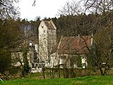
Liebenfels Castle

Old school house


Web links
Individual evidence
- ↑ Swiss land use statistics. Completed on July 1, 1912. Published by the Federal Statistical Bureau. ( Memento from April 12, 2016 in the Internet Archive )
- ↑ a b c d Localities and their resident population. Edition 2019 . On the website of the Statistical Office of the Canton of Thurgau (Excel table; 0.1 MB), accessed on April 28, 2020.
- ↑ Lanzenneunforn on ortsnamen.ch (online database), accessed on February 15, 2020
-
↑ a b c d
Erich Trösch: Lanzenneunforn. In: Historical Lexicon of Switzerland .
These sections are largely based on the entry in the Historical Lexicon of Switzerland (HLS), which, according to the HLS's usage information, is under the Creative Commons license - Attribution - Share under the same conditions 4.0 International (CC BY-SA 4.0). - ↑ a b municipal coat of arms . On the website of the State Archives of the Canton of Thurgau, accessed on December 8, 2019
- ↑ Locations and Settlements Directory. Canton of Thurgau, 2005 edition . On the website of the Statistical Office of the Canton of Thurgau (PDF; 1.7 MB), accessed on April 28, 2020.
- ↑ Locations and Settlements Directory. Canton of Thurgau, 2012 edition. On the website of the Statistical Office of the Canton of Thurgau (PDF; 3.4 MB), accessed on May 11, 2020.
Remarks
- ↑ with outside courtyards
Basadingen-Schlattingen | Berlingen | Diessenhofen | Eschenz | Felben-Wellhausen | Frauenfeld | Gachnang | Herdern | Homburg | Hüttlingen | Hüttwilen | Mammers | Matzingen | Muellheim | Nine-shape | Pfyn | Schlatt | Steckborn | Stettfurt | Thundorf | Uesslingen book | Wagenhausen | Warth-Weiningen
Former municipalities: Basadingen | Book near Frauenfeld | Dettighofen | Eschikofen | Fahrhof | Felben | Gerlikon | Gündelhart-Hörhausen | Harenwilen | Herten | Horgenbach | Huben | Islikon | Kaltenbach | Kefikon | Kurzdorf | Langdorf | Langenhart | Lance neunforn | Lustdorf | Mett-Oberschlatt | Mettendorf | Niederneunforn | Niederwil | Walnut trees | Oberneunforn | Oberwil | Rheinklingen | Salen-Reutenen | Schlattingen | Uerschhausen | Uesslingen | Subdivision | Warth | Weiningen | Wellhausen | Wetzikon | Wilen bei Neunforn | Willisdorf
Canton of Thurgau | Districts of the Canton of Thurgau | Municipalities of the Canton of Thurgau