Wetzikon TG
| TG is the abbreviation for the canton of Thurgau in Switzerland and is used to avoid confusion with other entries of the name Wetzikon . |
| Wetzikon | ||
|---|---|---|
| State : |
|
|
| Canton : |
|
|
| District : | Frauenfeld | |
| Political community : | Thundorf | |
| Postal code : | 8512 | |
| former BFS no. : | 4740 | |
| Coordinates : | 717 618 / 266 398 | |
| Height : | 612 m above sea level M. | |
| Area : | 2.69 km² | |
| Residents: | 113 (December 31, 2018) | |
| Population density : | 42 inhabitants per km² | |
|
Wetzikon lies on a foothill of the Immenberg, view from the south |
||
| map | ||
|
|
||
Wetzikon (in the local dialect [ˈʋetsikxə] ) is a town in the political municipality of Thundorf in the Swiss canton of Thurgau . Until 1994, Wetzikon and the hamlet of Gass were an independent local community that belonged to the Lommis municipal community . With the Thurgau community reform in 1995, Wetzikon was added to the political community of Thundorf .
geography
Wetzikon is located east of Frauenfeld on a foothill of the Immenberg at 610 to 620 meters above sea level above the steep north slope of the Lauchethal . To the southwest of the village, on the spur of the terrain above the Chuetobel, are the ruins of Spiegelberg Castle .
etymology
The oldest documents for the place name come from the years 827 (Wezzinchova) and 830 (Wezinchova) . This is (like the Wetzikon in the canton of Zurich ) composed of the frequent Old High German personal name Wazo / Wezo and the likewise common place name suffix - (i) kofen (mainly in Thurgau as well as in western German-speaking Switzerland) or, according to the current form of the name, with its abbreviated variant - (i) kon / - (i) ken (especially common in the cantons of Zurich , Aargau and Lucerne ), which refers to a fusion of the suffix -ing - ( e.g., `` in the case of the people named '') with the locative used dative pluralis of the word hof , yard, possession 'goes back.
history

The place was first mentioned in 827 as Wezzinchova . In the High Middle Ages , Wetzikon was an imperial fiefdom, then a fiefdom of the Bishop of Constance , which the barons of Spiegelberg held in 1210. It was owned by the Counts of Toggenburg in 1376 and those of Montfort from 1402 to 1436 . With the reign Spiegelberg 1464 the village fell into the hands of men Muntprat of Spiegelberg, of which there is a 1468 opening was given (after a version of 1465). In 1629 the Fischingen monastery acquired the rule and proposed Wetzikon to the Lommis court , where it remained until 1798.
Ecclesiastically, Wetzikon shared the fate of Lommis until the Reformation in 1529, after which the Reformed Lustdorf joined, the Catholics stayed with Lommis.
In addition to arable, meadow and fruit cultivation, viticulture was also practiced until around 1900. In the 19th century, farms increasingly focused on cattle and dairy farming with a cheese dairy. From 1960 onwards, low-trunk crops replaced the tall-trunk fruit trees. Agriculture remained the main source of income.
coat of arms
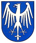
Blazon : white eagle on a blue background.
population
| year | 1831 | 1850 | 1900 | 1950 | 1990 | 2000 | 2010 | 2018 |
| Local parish | 169 | 162 | 120 | 114 | 79 | |||
| Locality | 86 | 97 | 113 | |||||
| source | ||||||||
Attractions
To the southwest of Wetzikon lie the ruins of the former Spiegelberg Castle , which was built in the 13th century by the Barons von Spiegelberg . Since 1639 the castle was owned by the Fischingen monastery . It was demolished in 1821 along with its chapel. The ruin is included in the list of cultural assets in Thundorf .
Web links
Individual evidence
- ↑ Swiss land use statistics. Completed on July 1, 1912. Published by the Federal Statistical Bureau. ( Memento from April 12, 2016 in the Internet Archive )
- ↑ a b c Localities and their resident population. Edition 2019 . On the website of the Statistical Office of the Canton of Thurgau (Excel table; 0.1 MB), accessed on April 28, 2020.
- ↑ a b Eugen Nyffenegger / Oskar Bandle & al .: Thurgau Name Book 1.2: The settlement names of the Canton of Thurgau (K – Z). Huber, Frauenfeld 2003, ISBN 978-3-7193-1309-8 , p. 1375 s. v. Wetzikon .
-
↑ a b c d e Erich Trösch: Wetzikon (TG). In: Historical Lexicon of Switzerland .
These sections are largely based on the entry in the Historical Lexicon of Switzerland (HLS), which, according to the HLS's usage information, is under the Creative Commons license - Attribution - Share under the same conditions 4.0 International (CC BY-SA 4.0). - ↑ Andres Kristol, Wetzikon ZH (Hinwil) in: Dictionnaire toponymique des communes suisses - Lexicon of Swiss community names - Dizionario toponomastico dei comuni svizzeri (DTS | LSG) , Center de dialectologie, Université de Neuchâtel, Verlag Huber, Frauenfeld / Stuttgart / Vienna 2005 , ISBN 3-7193-1308-5 and Éditions Payot, Lausanne 2005, ISBN 2-601-03336-3 , p. 963.
- ↑ Locations and Settlements Directory. Canton of Thurgau, 2005 edition . On the website of the Statistical Office of the Canton of Thurgau (PDF; 1.7 MB), accessed on April 28, 2020.
- ↑ Locations and Settlements Directory. Canton of Thurgau, 2012 edition. On the website of the Statistical Office of the Canton of Thurgau (PDF; 3.4 MB), accessed on May 11, 2020.
Remarks
- ↑ with outside courtyards


