Basadingen
| Basadingen | |
|---|---|
| State : |
|
| Canton : |
|
| District : | Frauenfeld |
| Political community : | Basadingen-Schlattingen |
| Postal code : | 8254 |
| former BFS no. : | 4531 |
| Coordinates : | 698 175 / 280 636 |
| Height : | 413 m above sea level M. |
| Area : | 8.7 km² (local parish ) 31.00 km² (municipality) |
| Residents: | 1077 (December 31, 2018) |
| Population density : | 124 inhabitants per km² |
|
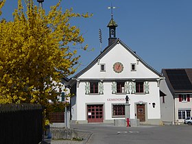
Parish hall |
|
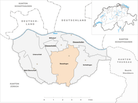
| map | |
Basadingen is a former local and municipal municipality and a village in the municipality of Basadingen-Schlattingen in the Frauenfeld district of the canton of Thurgau in Switzerland .
The municipal community, which existed from 1816 to 1998, comprised the local communities of Basadingen, Schlattingen , Mett-Oberschlatt and Unterschlatt . On January 1, 1999 , the local parishes of Basadingen and Schlattingen merged to form the political municipality of Basadingen-Schlattingen and the local parishes of Mett-Oberschlatt and Unterschlatt to form the political municipality of Schlatt TG .
geography
Basadingen is located south of Diessenhofen and just under two kilometers west of Schlattingen in the Geisslibach basin on the road from Diessenhofen to Trüllikon . The clustered village of the Geisslibach is characterized by half-timbered buildings from the 17th to 19th centuries along the triangle of the main streets. The church is northeast of the stream, surrounded by traditional farmhouses. The situation around the parish hall achieves a special spatial quality.
history
Early settlement witnesses are finds from the Neolithic Age on the Buchberg and at Dickihof as well as a Roman villa with a burial ground in Unterschlatt. Basadingen is first mentioned as Pasnandingas in a document from 761. This letter declares the sale of goods to the St. Gallen monastery. From the early Middle Ages on, the monasteries of St. Gallen , Rheinau , Reichenau and All Saints were wealthy in Basadingen. In 1260 the St. Katharinental Monastery bought the Reichenauer Kehlhof . Until 1330 it acquired numerous estates, the lower court and the tithe , so that from then on it was almost the sole lord of the village. The high court is believed to have belonged to the Diessenhofen Bailiwick from around 1300 and came to the city of Diessenhofen in 1460 , which also exercised the lower jurisdiction in Basadingen from 1527 to 1798.
From the high Middle Ages , Basadingen belonged partly to Stammheim and partly to the parish of Basadingen, which was built around the Martinskirche in the 13th century at the latest. The latter was incorporated into the monastery of St. Katharinental in 1264. After the Reformation in 1529, the parish of Basadingen and the Stammheim part of Basadingen were merged to form the parish of Basadingen, to which Willisdorf also came. In 1631, with the appointment of a Catholic pastor, the simultaneity, which continues to this day, began . The existing church was consecrated in 1845.
The number of farms, all of which were integrated into the village Zelgensystem and structured in a similar way, fell from around 40 to 16 between 1328 and 1433, only to double again between 1470 and 1550. After that, the appearance of the settlement, the system of use and the abandoned area remained stable until around 1800, while the number of farms - which are still focused on arable farming - increased significantly. Extensive forests encouraged the woodworking industry to flourish. Around 1900 an embroidery shop and a brickyard offered some factory jobs, but Basadingen's rural character was retained until 1970. Since then, agricultural improvements with the abandonment of extensive fruit growing and strong population growth with new single-family houses have changed the settlement and landscape.
coat of arms
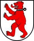
Blazon : In silver with an upright striding red bear with a black collar.
The bear reminds us that the St. Gallen and Reichenau monasteries owned goods in Basadingen. It comes from the St. Gallen Monastery, the colors red and white from the Reichenau Abbey.
population
| 1850 | 1900 | 1950 | 1980 | 1990 | 2000 | 2010 | 2018 | |
|---|---|---|---|---|---|---|---|---|
| Municipal parish | 2169 | 1885 | 2429 | 2049 | 2574 | |||
| Local parish | 763 | 662 | 792 | 681 | 821 | |||
| Locality | 858 | 923 | 1077 | |||||
| source | ||||||||
Of the total of 1,077 inhabitants in Basadingen in 2018, 153 or 14.2% were foreign nationals. 415 (38.5%) were Protestant Reformed and 315 (29.2%) were Roman Catholic.
Personalities
- Hans Brändli (1896–1974), pastor and honorary citizen of Basadingen
- Johann Caspar Häfeli (1754–1811), Catholic theologian and teacher
- Anton Keller (1831–1852), painter
Townscape
The townscape in Basadingen is characterized by the large church and the old buildings in the village center. There are many agricultural areas around the village and a little further on the forest. Occasionally, for example, you can find some grapevines on the Guggebüel hill .
The Catholic rectory is included in the list of cultural assets in Basadingen-Schlattingen .
literature
- Martin Forster: 1200 years of Basadingen. In: Thurgauer Jahrbuch . Volume 37, 1962, pp. 59-68 ( e-periodica.ch )
- Gregor Spuhler : Basadingen. In: Historical Lexicon of Switzerland . This article is largely based on the entry in the Historisches Lexikon der Schweiz (HLS), which, according to the HLS's usage information, is licensed under the Creative Commons - Attribution - Distribution under the same conditions 4.0 International (CC BY-SA 4.0) license .
Web links
Individual evidence
- ↑ Numbers / facts. On the website of the municipality of Basadingen-Schlattingen, accessed on December 16, 2019
- ↑ Swiss land use statistics. Completed on July 1, 1912. Published by the Federal Statistical Bureau. ( Memento from April 12, 2016 in the Internet Archive )
- ↑ a b c d Localities and their resident population. Edition 2019 . On the website of the Statistical Office of the Canton of Thurgau (Excel table; 0.1 MB), accessed on April 28, 2020.
- ↑ Population development of the municipalities. Canton of Thurgau, 1850-2000. On the website of the Statistical Office of the Canton of Thurgau (Excel table; 0.1 MB), accessed on April 28, 2020.
- ^ Alfons Raimann: Parish Basadingen-Schlattingen. In: Office for the Preservation of Monuments of the Canton of Thurgau (Hrsg.): Preservation of monuments in Thurgau. Vol. 6. Huber Verlag, Frauenfeld 2004. ISBN 3-7193-1369-7 . P. 208 f.
- ↑ StiASG , Urk. I 24. Online at e-chartae , accessed on June 12, 2020.
- ↑ a b municipal coat of arms . On the website of the State Archives of the Canton of Thurgau, accessed on December 8, 2019
- ↑ Locations and Settlements Directory. Canton of Thurgau, 2005 edition . On the website of the Statistical Office of the Canton of Thurgau (PDF; 1.7 MB), accessed on April 28, 2020.
- ↑ Locations and Settlements Directory. Canton of Thurgau, 2012 edition. On the website of the Statistical Office of the Canton of Thurgau (PDF; 3.4 MB), accessed on May 11, 2020.
- ↑ Häfelin, Johann Caspar (1754-1811). On the website of the Kalliope network, accessed on September 2, 2019.
Remarks
- ↑ with outside courtyards


