
Schlatt TG
| TG is the abbreviation for the canton of Thurgau in Switzerland and is used to avoid confusion with other entries of the name Schlatt . |
| Schlatt | |
|---|---|
 |
|
| State : |
|
| Canton : |
|
| District : | Frauenfeld |
| BFS no. : | 4546 |
| Postal code : | 8252 |
| Coordinates : | 694.77 thousand / 278 467 |
| Height : | 416 m above sea level M. |
| Height range : | 377-563 m above sea level M. |
| Area : | 15.54 km² |
| Residents: | 1708 (December 31, 2018) |
| Population density : | 110 inhabitants per km² |
| Website: | www.schlatt.ch |
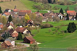
 Schlatt TG from the observation tower on the Kohlfirst |
|
| Location of the municipality | |
  |
|
Schlatt (TG) is a village and since 1999 has been a political municipality in the Frauenfeld district of the canton of Thurgau in Switzerland . The reformed parish bears the name Schlatt near Diessenhofen .
geography

The community lies between Frauenfeld and Schaffhausen in Schlattertal on the eastern slope of the Cholfirst . It is the westernmost municipality in the canton of Thurgau and borders the area of the canton of Zurich. The local community of Mett-Oberschlatt and the local community of Unterschlatt form a spatial and cultural-historical unit. It was restored in 1999 through the merger of the two local parishes after the old Schlatt had been divided up at the beginning of the 19th century.
In addition to the village of Unterschlatt, the former community of Unterschlatt includes the districts of Dickihof in the south-east, Altparadies with the former Paradies monastery and the industrial estate Neuparadies, which emerged in the 19th and 20th centuries . The former local community Mett-Oberschlatt was made up of the districts Mettschlatt, Oberschlatt and Fallentor.
The former gravel pit in the Gishalde is now used as a training track for off-road vehicles.
Schlatt has an international border with the exclave Büsingen am Hochrhein (Germany).
history
Slate was first mentioned in a document in 858. The political municipality Schlatt has existed since January 1st, 1999 and unites the two former municipalities Mett-Oberschlatt and Unterschlatt of the former municipal municipality Basadingen . Until 2010, Schlatt belonged to the Diessenhofen district .
→ see also the history section in the Mett-Oberschlatt article
→ see also the history section in the Unterschlatt article
coat of arms


Blazon : Diagonally divided by yellow with a striding red lion and by red with a yellow ploughshare .
The coat of arms of the community Schlatt was combined from the coats of arms of the local communities Mett-Oberschlatt and Unterschlatt when the community was founded. The lion probably refers to the Kyburger , the ploughshare stands for the agricultural character of the community.
population
 |
| 1800 | 1831 | 1850 | 1870 | 1900 | 1950 | 1990 | 2000 | 2010 | 2018 | |
|---|---|---|---|---|---|---|---|---|---|---|
| Political community | 1485 | 1601 | 1698 | |||||||
| Mett-Oberschlatt parish | 203 | 287 | 332 | 257 | 317 | 326 | ||||
| Local community of Unterschlatt | 466 | 631 | 636 | 633 | 914 | 915 | ||||
Of the total of 1698 inhabitants in the municipality of Schlatt in 2018, 187 or 11.0% were foreign nationals. 912 (53.7%) were Protestant Reformed and 297 (17.5%) were Roman Catholic.
economy
In 2016, Schlatt offered 403 jobs (converted to full-time positions). Of these, 15.2% were employed in agriculture and forestry, 41.5% in industry, trade and construction and 43.3% in the service sector.
Attractions
The Paradies monastery is listed in the inventory of places worth protecting in Switzerland .
→ see also the article List of cultural assets in Schlatt TG
→ see also the Sights section in the article Mett-Oberschlatt
Dickihof

A burial mound suggests that the hamlet of Dickihof was probably inhabited as early as the Hallstatt period. The settlement is described as belonging to the Ittingen Charterhouse in 1162 , and the church prince Ticchi is said to have resided in this place. This rural hamlet , the oldest structure of which probably dates back to the 18th century, is still roughly the same today as on the Siegfried map from 1883. The hamlet of Dickihof is listed in the inventory of places worthy of protection in Switzerland .
photos
Oberschlatt in front, Mettschlatt behind

Oberschlatt in 1954

Altparadies monastery church

Neuparadies lift tower


literature
- Alfons Raimann: The art monuments of the Canton of Thurgau, Volume V: The Diessenhofen district. Edited by the Society for Swiss Art History GSK. Bern 1992 (Art Monuments of Switzerland, Volume 85). ISBN 3-909158-73-0 . Pp. 254-283.
Web links
Individual evidence
- ↑ Permanent and non-permanent resident population by year, canton, district, municipality, population type and gender (permanent resident population). In: bfs. admin.ch . Federal Statistical Office (FSO), August 31, 2019, accessed on December 22, 2019 .
- ↑ a b Thurgau in figures 2019 . On the website of the Statistical Office of the Canton of Thurgau (PDF file; 1.8 MB), accessed on April 28, 2020.
- ↑ a b Localities and their resident population. Edition 2019 . On the website of the Statistical Office of the Canton of Thurgau (Excel table; 0.1 MB), accessed on April 28, 2020.
- ↑ Schlatt parish near Diessenhofen . On the website of the Evangelical Church of the Canton of Thurgau, accessed on December 20, 2019
- ↑ a b story. On the website of the municipality of Schlatt (TG), accessed on December 20, 2019
- ↑ Erich Trösch: Schlatt (TG). In: Historical Lexicon of Switzerland .
- ↑ a b municipal coat of arms . On the website of the State Archives of the Canton of Thurgau, accessed on December 8, 2019
- ↑ a b c population development of the municipalities. Canton Thurgau, 1850–2000 and resident population of the municipalities and change from the previous year. Canton of Thurgau, 1990–2018. On the website of the Statistical Office of the Canton of Thurgau (Excel tables; 0.1 MB each), accessed on April 28, 2020.
- ↑ a b Erich Trösch: Mett-Oberschlatt. In: Historical Lexicon of Switzerland .
- ↑ Erich Trösch: Unterlatt. In: Historical Lexicon of Switzerland .
Basadingen-Schlattingen | Berlingen | Diessenhofen | Eschenz | Felben-Wellhausen | Frauenfeld | Gachnang | Herdern | Homburg | Hüttlingen | Hüttwilen | Mammers | Matzingen | Muellheim | Nine-shape | Pfyn | Schlatt | Steckborn | Stettfurt | Thundorf | Uesslingen book | Wagenhausen | Warth-Weiningen
Former municipalities: Basadingen | Book near Frauenfeld | Dettighofen | Eschikofen | Fahrhof | Felben | Gerlikon | Gündelhart-Hörhausen | Harenwilen | Herten | Horgenbach | Huben | Islikon | Kaltenbach | Kefikon | Kurzdorf | Langdorf | Langenhart | Lance neunforn | Lustdorf | Mett-Oberschlatt | Mettendorf | Niederneunforn | Niederwil | Walnut trees | Oberneunforn | Oberwil | Rheinklingen | Salen-Reutenen | Schlattingen | Uerschhausen | Uesslingen | Subdivision | Warth | Weiningen | Wellhausen | Wetzikon | Wilen bei Neunforn | Willisdorf
Canton of Thurgau | Districts of the Canton of Thurgau | Municipalities of the Canton of Thurgau