
Eschenz
| Eschenz | |
|---|---|
 |
|
| State : |
|
| Canton : |
|
| District : | Frauenfeld |
| BFS no. : | 4806 |
| Postal code : | 8264 |
| Coordinates : | 707 290 / 278 682 |
| Height : | 412 m above sea level M. |
| Height range : | 395–654 m above sea level M. |
| Area : | 12.00 km² |
| Residents: | 1743 (December 31, 2018) |
| Population density : | 145 inhabitants per km² |
| Website: | www.eschenz.ch |
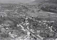
 Eschenz and the Werdinseln |
|
| Location of the municipality | |
  |
|
Eschenz is a municipality and a town in the district of Frauenfeld of the canton of Thurgau in Switzerland . Until 2002 Eschenz was a unified community .
geography
Eschenz is located on the south bank of the Rhine Lake, in front of the outflow of the High Rhine from Lake Constance ( Untersee ). Hence the name Eschenz on Untersee and Rhine. One of the smaller Lake Constance islands, the island of Werd, is located in the municipality . Today, the place has almost grown together with the Burg district of the small town of Stein am Rhein . It has a stop on the Schaffhausen – Rorschach lake line and is on the Stein am Rhein – Frauenfeld post bus connection .
In addition to the actual village center, the community also includes a large number of districts, including Bornhausen, Eppenberg, Freudenfels Castle, Hirschensprung, Rappenhof, Werd Island , Windhausen, Grüneck and others.
To the north, in the middle of the Rhine, runs the border between Germany and Switzerland .
history
Early history

The prehistoric shoreline settlements on the island of Werd and in the “Seeäckern” northeast of Eschenz, which have become known up to now, are characterized by extensive finds that made a significant contribution to clarifying the settlement history in the narrower Lake Constance area . The two Werdinseln, located in the outflow area of the Untersee and Hochrhein, owe their formation to postglacial limestone deposits . Natural fords in the Rhine favored settlement activity over almost all prehistoric and early historical epochs. In 1858 the settlement was discovered on the main island. The excavation campaign of 1882/83 by Schenk was followed by extensive scientific investigations by Karl Keller-Tarnuzzer from 1931 to 1936 as well as smaller explorations in the Otmar Chapel in 1962 . Accordingly, numerous interesting finds were made, some of international importance. Among them are the famous gold cup by Eschenz (2000 BC) and a Gallo-Roman wooden figure (60–70 AD).

The island of Werd was first settled shortly after 4000 BC. BC (early Pfyn culture ) and coincides with the number of settlements in the pre-alpine wetlands at the beginning of the early Neolithic . A second phase of settlement (late Pfyner culture) began after a long interruption before the middle of the 4th millennium. After a third settlement phase ( Horgen culture , second half of the 4th millennium), a rise in the lake level - this is documented by mighty layers of sea chalk - should have flooded the entire island. The Neolithic settlement activity ended with a cord ceramic settlement in the first half of the 3rd millennium; Traces of settlement can only be seen again in the middle section of the Late Bronze Age (11th century BC). Again, a flood horizon in the strata profile of the island shows an interruption of settlement and separates the cultural layer deposits from the final phase of the Late Bronze Age (9th century BC). Numerous found horse bridle components suggest that the island was a transshipment point thanks to its favorable traffic situation .
In the early 1st century AD, the Romans built a village ( vicus ) Tasgetium and a wooden bridge over the island of Werd to the other shore of the lake. In addition, in the 4th century, a fort Eschenz was built in “Vor der Brugg” (Stein am Rhein), which served as a border fort for a large-scale facility to defend the Danube-Iller-Rhine-Limes and to protect it from the Allemann raids. The inhabitants lived from agriculture, animal husbandry and fishing. The emergence of the Eschenz fort probably led to a population decline in the Eschenz area. The departure of the Romans took place shortly after 400; there followed a peaceful conquest of land by the Alemanni .
Middle Ages and early modern times

Little is known about the time up to the 10th century. Otmar, the first abbot of the Benedictine Abbey of St. Gallen , spent the last months of his exile on the island of Werd and died here in 759. At that time, a predecessor to the Romanesque chapel that still exists today must have existed on the island. As a result, Werd developed into a place of pilgrimage. In 799 Eschenz was first mentioned in a document as Exsientia . At that time there may have been one or two manors in the area of today's Untereschenz and Obereschenz.
In 958 King Otto I gave the still very young Benedictine monastery Einsiedeln a church that already existed in Untereschenz, the island of Werd and its church (still in its possession today) and a nearby estate . From this core of the settlement developed in the following centuries, thanks to extensive deforestation and expanded to the east and the hilly terrain of the lake ridge up from. An opening dates from 1296 . Eschenz certainly benefited from the development of the neighboring medieval trading town of Stein am Rhein. Eschenz subsequently developed into a rule with lower jurisdiction , which the governor of Einsiedeln Monastery exercised at Freudenfels Castle from 1623 to 1798.

The parish of Eschenz, which was formally incorporated into the monastery in 1362 , emerged from the church in Untereschenz through the pastoration of Einsiedeln . Between 1525 and 1529 Eschenz converted to the new faith and until 1569 only Protestant services were held. Then the church served both denominations for 10 years. In 1580, after the re-Catholicization had been vigorously and successfully promoted, the Evangelicals were assigned to the parish of Burg (Stein am Rhein). The cemetery in Eschenz was used equally until 1690 . The current Catholic Church in Obereschenz was built in 1737; the church in Untereschenz was demolished. The parish of Eschenz also includes the Catholics of the Wagenhausen political community . Einsiedeln has been renting the St. Otmar and Insel Werd chapel to a small Franciscan community for over 30 years . a. Pastoration in the surrounding communities.

Around 1300, the Freudenfels Fortress was built on a rock spur one kilometer south-east of Obereschenz . It represented a link in the chain of fortifications that were owned by the Lords of Hohenklingen (with headquarters at Hohenklingen Castle ) and served to protect Stein am Rhein and the flourishing merchant shipping on the Untersee. At the same time, the jurisdiction of the same name was administered from here. The founding of the Klingenzell Priory also goes back to this family.
After numerous (speculative justified) changes of hands - among the owners we also find the Dukes of Austria - the rule of Freudenfels came into the possession of Einsiedeln in 1623. The monastery acquired this at the instigation and with the support of the Swiss Benedictine Congregation , which wanted to consolidate and expand the re-Catholicization of the area. The rule of Eschenz was now united with that of Freudenfels in one hand. In the course of the Helvetic Republic (1798–1803), the Freudenfels-Eschenz lordship lost its judicial privileges and its landed property and gradually melted into what it is today: the castle complex and farm - both of which are still owned by Einsiedeln. The palace buildings were redesigned from 1989–1992 into a training and meeting center that is currently rented to a bank on a long-term basis.
Modern times
In 1803, the (today's political) municipality of Eschenz took the place of the two partial dominions. In terms of its area, it was initially more extensive than its united predecessors. In 1851 it shrank considerably due to the separation of the municipality of Hüttwilen on the other side of the lake from the municipality of Eschenz. In terms of population, this meant a loss of 50 percent. Eschenz initially remained a pure farming village, in the vicinity of which viticulture was practiced on a large scale and not a small amount of fishing from the Middle Ages until the phylloxera and powdery mildew epidemics of the late 19th century. There were also some craftsmen in the village. The village centers of Untereschenz and Obereschenz, which were already identifiable in the 17th century, were by no means merged with one another. The spatially identical local and municipal parish of Eschenz were merged in 1870 to form a single parish of Eschenz.
Its location on the Seestrasse to Konstanz did not help it to develop significantly, although from 1846 the stagecoach stopped at the Raven. The direct road connection (1861) over the Seerücken to the canton capital and the Thur valley as well as the connection to the railway network (station construction 1875; lines Winterthur – Etzwilen – Konstanz and from 1895 Schaffhausen – Stein am Rhein ) brought little changes. A settlement of industrial companies did not take place. In place of viticulture and fishing, agriculture and livestock farming emerged at the turn of the century.
It was not until 1931 that the first and only factory, the Unipektin, a company from the food industry, which today secures 80 high-quality jobs, was built. The district of Grüneck has received an American thank you plaque for accepting American bomber pilots in World War II.
A seamless transition between Unter- and Obereschenz did not come about until after 1960 with the construction of the national road, when a certain construction boom also began in Eschenz. Today, businesses and houses characterize the village, while individual farms, hamlets and extensive forest areas characterize the landscape.
coat of arms
Blazon : split , on the right in yellow a red erect lion , on the left of blue and white divided diagonally right five times .
The Lords of Eschenz had a red lion in their coat of arms, but research assumes that it was the Habsburg lion. Nevertheless, the coat of arms of the Reichau ministerial is very similar. There were two variants in the heraldic books. The municipality of Diegten in Baselland has the same coat of arms as Eschenz, but it is in yellow, black and white.
population
 |
| year | 1850 | 1900 | 1950 | 1980 | 1990 | 2000 | 2010 | 2018 |
| Residents | 1032 | 929 | 1101 | 1211 | 1356 | 1513 | 1665 | 1741 |
Of the total of 1741 inhabitants in the municipality of Eschenz in 2018, 318 or 18.3% were foreign nationals. 585 (33.6%) were Protestant Reformed and 550 (31.6%) were Roman Catholic.
Attractions

Prehistoric pile dwellings were found on the island of Werd . The site has been part of the UNESCO World Heritage Site of Prehistoric Pile Dwellings around the Alps since 2011 . The Eschenz Basin is listed in the inventory of places worth protecting in Switzerland .
Personalities
- Paul Joseph Reichsgraf von Beroldingen (1754–1831), diplomat and politician
- Hans Niederhauser (* 1930), painter
- Richard Tisserand (* 1948), painter and draftsman
economy
Eschenz has a lively trade, from road construction to carpentry to horse boarding and from fiduciary to metal workers to garden design. In 2016, Eschenz offered 418 people work (converted to full-time positions). Of these, 13.4% were employed in agriculture and forestry, 38.8% in industry, trade and construction and 47.9% in the service sector.
The largest employer in the municipality is Unipektin AG; Founded in 1936, it now has around 80 employees who work in the four business areas of technical fruit processing, thickeners, mechanical engineering and international trade in fruit concentrates and fruit aromas.
literature
- Alfons Raimann, Peter Erni: The art monuments of the Canton of Thurgau, Thurgau VI. The Steckborn district. Edited by the Society for Swiss Art History GSK. Bern 2001 (Art Monuments of Switzerland, Volume 98). ISBN 3-906131-02-5 .
- Office for archeology of the canton of Thurgau (ed.): Tasgetium I - the Roman Eschenz. 2011, ISBN 978-3-905405-20-0 . (Volume 17 of the series "Archeology in Thurgau".)
- ETH Zurich : The gold cup from Eschenz , Zurich 1975, doi : 10.5169 / seals-166350 .
Web links
Individual evidence
- ↑ Permanent and non-permanent resident population by year, canton, district, municipality, population type and gender (permanent resident population). In: bfs. admin.ch . Federal Statistical Office (FSO), August 31, 2019, accessed on December 22, 2019 .
- ↑ a b Thurgau in figures 2019 . On the website of the Statistical Office of the Canton of Thurgau (PDF file; 1.8 MB), accessed on April 28, 2020.
- ↑ a b Localities and their resident population. Edition 2019 . On the website of the Statistical Office of the Canton of Thurgau (Excel table; 0.1 MB), accessed on April 28, 2020.
- ↑ a b municipal coat of arms . On the website of the State Archives of the Canton of Thurgau, accessed on December 8, 2019
-
^ A b Albin Hasenfratz, Verena Rothenbühler: Eschenz. In: Historical Lexicon of Switzerland .
These sections are largely based on the entry in the Historical Lexicon of Switzerland (HLS), which, according to the HLS's usage information, is under the Creative Commons license - Attribution - Share under the same conditions 4.0 International (CC BY-SA 4.0). - ^ Archeology Canton Thurgau: Walk through the history of Eschenz
- ^ Museum of Archeology Thurgau
- ↑ a b Population development of the municipalities. Canton Thurgau, 1850–2000 and resident population of the municipalities and change from the previous year. Canton of Thurgau, 1990–2018. On the website of the Statistical Office of the Canton of Thurgau (Excel tables; 0.1 MB each), accessed on April 28, 2020.
- ↑ Source: Vorarlberger Landesmuseum Bregenz, in: Listed! Finds of pile dwellings on the Untersee In: Südkurier from September 9, 2011
- ↑ Book description (PDF; 345 kB) ( Memento from December 20, 2015 in the Internet Archive ), on the website of the Office for Archeology of the Canton of Thurgau, accessed on October 7, 2011.
Basadingen-Schlattingen | Berlingen | Diessenhofen | Eschenz | Felben-Wellhausen | Frauenfeld | Gachnang | Herdern | Homburg | Hüttlingen | Hüttwilen | Mammers | Matzingen | Muellheim | Nine-shape | Pfyn | Schlatt | Steckborn | Stettfurt | Thundorf | Uesslingen book | Wagenhausen | Warth-Weiningen
Former municipalities: Basadingen | Book near Frauenfeld | Dettighofen | Eschikofen | Fahrhof | Felben | Gerlikon | Gündelhart-Hörhausen | Harenwilen | Herten | Horgenbach | Huben | Islikon | Kaltenbach | Kefikon | Kurzdorf | Langdorf | Langenhart | Lance neunforn | Lustdorf | Mett-Oberschlatt | Mettendorf | Niederneunforn | Niederwil | Walnut trees | Oberneunforn | Oberwil | Rheinklingen | Salen-Reutenen | Schlattingen | Uerschhausen | Uesslingen | Subdivision | Warth | Weiningen | Wellhausen | Wetzikon | Wilen bei Neunforn | Willisdorf
Canton of Thurgau | Districts of the Canton of Thurgau | Municipalities of the Canton of Thurgau