
Kurzdorf
| Kurzdorf | ||
|---|---|---|
| State : |
|
|
| Canton : |
|
|
| District : | Frauenfeld | |
| Political community : | Frauenfeld | |
| Postal code : | 8503 | |
| Coordinates : | 709 272 / 268 787 | |
| Height : | 404 m above sea level M. | |
| Area : | 2.02 km² | |
| Residents: | 7216 (December 31, 2018) | |
| Population density : | 3572 inhabitants per km² | |
| Website: | www.quartierverein-kurzdorf.ch | |
 Reformed Church of St. Johann from 1915 in Kurzdorf |
||
| map | ||
|
||

Kurzdorf [ ˈkxʊrtsdɔrf ] (in the local dialect : [ (s) xʊʀtsˈd̥ɔːʀfˑ ] or [ ˈxuʀtːsd̥ɔːʀfˑ ]) is a former municipality in the municipal municipality of Frauenfeld and is now a district of the city of Frauenfeld in the Swiss canton of Thurgau . 1919 merged the local church Kurzdorf for unified community Frauenfeld.
geography
Kurzdorf is located northwest of the city center on the left side of the Murg .
Surname
The old name of both the long village and the short village is Erchingen ; the addition Kurz (en) - is first documented in 1316 ( Kurtzenerchingen ; next to it as early as 1312: in villa zem long Erchingen ) and is due to the different shape of the two parts of the settlement: Kurzenerchingen was a so-called cluster village , while Langenerchingen was a long street village .
The replacement of the name Erchingen by the simple word dorf appears for the first time in 1328 (ze der obrun kilchun ze Erchingen ... ze der kilchun ze dem Kurzendorfe ) and was completed in the 18th century (1743 by Heini Funsting from Langen Erchingen now Langdorff called ).
history
The former clustered village is located on the Roman road from Winterthur to Pfyn . In 889 the East Franconian King Arnulf confirmed Erchingen as the property of the Reichenau Monastery . Since the 13th century it belonged to the Habsburg-Kyburg office of Frauenfeld and later to 1798 to the city court. The county high court met until 1417 at the arbor.


Shortly village belonged to the parish Frauenfeld-Oberkirch, was reformed in 1529 and 1534 parity . The Church of St. John remained reformed.
The short village, originally focused on growing grain, had a mill in the 14th century. From 1840 onwards, with the introduction of cotton spinning, silk twining , embroidery and foundries , the town experienced a major economic change. A gas works was added in 1878 and an iron works in 1908.
| year | 1831 | 1850 | 1900 | 1910 |
| Residents | 216 | 347 | 1042 | 1251 |
Attractions
The Reformed Church of St. Johann, the former ironworks and the two objects shown below are included in the list of cultural assets in Frauenfeld .

Half-timbered house with attached living area at Laubgasse 45
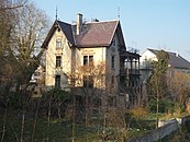
Villa Brenner at Gaswerkstrasse 4


Web links
Individual evidence
- ↑ Swiss land use statistics. Completed on July 1, 1912. Published by the Federal Statistical Bureau. ( Memento from April 12, 2016 in the Internet Archive )
- ↑ List of settlements. Canton of Thurgau, edition 2019 . On the website of the Statistical Office of the Canton of Thurgau (Excel table; 0.2 MB), accessed on May 10, 2020.
- ↑ Eugen Nyffenegger / Oskar Bandle & al., Thurgau Name Book 1.1: The settlement names of the Canton of Thurgau (A – I) , Huber, Frauenfeld 2003, ISBN 978-3-7193-1309-8 , p. 454f., Erchingen .
-
↑ a b c d Erich Trösch: Kurzdorf. In: Historical Lexicon of Switzerland .
These sections are largely based on the entry in the Historical Lexicon of Switzerland (HLS), which, according to the HLS's usage information, is under the Creative Commons license - Attribution - Share under the same conditions 4.0 International (CC BY-SA 4.0).
Basadingen-Schlattingen | Berlingen | Diessenhofen | Eschenz | Felben-Wellhausen | Frauenfeld | Gachnang | Herdern | Homburg | Hüttlingen | Hüttwilen | Mammers | Matzingen | Muellheim | Nine-shape | Pfyn | Schlatt | Steckborn | Stettfurt | Thundorf | Uesslingen book | Wagenhausen | Warth-Weiningen
Former municipalities: Basadingen | Book near Frauenfeld | Dettighofen | Eschikofen | Fahrhof | Felben | Gerlikon | Gündelhart-Hörhausen | Harenwilen | Herten | Horgenbach | Huben | Islikon | Kaltenbach | Kefikon | Kurzdorf | Langdorf | Langenhart | Lance neunforn | Lustdorf | Mett-Oberschlatt | Mettendorf | Niederneunforn | Niederwil | Walnut trees | Oberneunforn | Oberwil | Rheinklingen | Salen-Reutenen | Schlattingen | Uerschhausen | Uesslingen | Subdivision | Warth | Weiningen | Wellhausen | Wetzikon | Wilen bei Neunforn | Willisdorf
Canton of Thurgau | Districts of the Canton of Thurgau | Municipalities of the Canton of Thurgau