Rheinklingen
| Rheinklingen | ||
|---|---|---|
| State : |
|
|
| Canton : |
|
|
| District : | Frauenfeld | |
| Political community : | Wagenhausen | |
| Postal code : | 8259 | |
| former BFS no. : | 4872 | |
| Coordinates : | 702.87 thousand / 281 539 | |
| Height : | 408 m above sea level M. | |
| Area : | 2.85 km² | |
| Residents: | 139 (December 31, 2018) | |
| Population density : | 49 inhabitants per km² | |
|
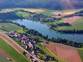
Rheinklingen, on the other side of the Rhine the Bibermühle |
||
| map | ||
|
|
||
Rheinklingen is a former municipality and a village in the Wagenhausen municipality in the Frauenfeld district of the canton of Thurgau in Switzerland .
From 1798 to 1995 Rheinklingen was part of the municipality of Wagenhausen and from 1838 to 1995 a local community. On June 1, 1995 , the local community merged with the municipal community Wagenhausen and the local communities Wagenhausen and Kaltenbach to form the political community of Wagenhausen.
geography
Rheinklingen is a rural clustered village below Stein am Rhein and is located at the foot of the Rodenberg on the left side of the High Rhine .
history
According to the excavation in 1996, Rheinklingen is a high medieval settlement on the remains of a Roman watchtower on the Burgstall on the Rhine . The name of the place goes back to an Alemanni named Rikile. Over time, the village name was spelled differently in different documents, such as the first in 868 as Richilingun , 888 Richilingen and 903 as Richilinga. In 1336 the name Richlingen was recorded, a little later it became Reichlingen and in 1838 today's spelling prevailed.
The monasteries of Allerheiligen , Feldbach and Wagenhausen owned farms in Rheinklingen in the Middle Ages . In 1315 Ulrich von Klingen gave his property in Rheinklingen to the St. Georgen monastery . From 1433 Rheinklingen can be identified as part of the Vogtei Wagenhausen, which belonged to the town of Stein am Rhein from 1575 to 1798 . After Burg bei Stein am Rhein, Rheinklingen was always part of the church.
Up until the 19th century, the Vetterli von Rheinklingen towed the so-called Ledines from Diessenhofen to Stein am Rhein. The residents grew arable, fruit and wine and the community was still strongly rural in the first half of the 20th century. In 1969 the Nordostschweizerische Kraftwerke (NOK) acquired 18 hectares of land in order to build a nuclear power plant near Rheinklingen. From 1974 the project was not pursued any further. In 1980 39% of the employed people living in Rheinklingen were commuters.
population
| year | 1850 | 1900 | 1950 | 1990 | 2000 | 2010 | 2018 |
| Local parish | 156 | 124 | 146 | 140 | |||
| Locality | 122 | 90 | 139 | ||||
| source | |||||||
Of the total of 139 inhabitants in Rheinklingen in 2018, 6 or 4.3% were foreign nationals. 99 (71.2%) were Protestant Reformed and 8 (5.8%) were Roman Catholic.
traffic
Rheinklingen is on Hauptstrasse 13 , which takes less than 10 minutes to get to Stein am Rhein or Diessenhofen . Rheinklingen is not served by public transport. The nearest train station is 1.5 kilometers away in Etzwilen .
Attractions
The place is listed in the inventory of places worthy of protection in Switzerland and is also called " Ballenberg des Thurgau" because Rheinklingen is almost exclusively old farmhouses.
The railway bridge of the national railway , half of which lies in the municipal area of Wagenhausen and Hemishofen , is included in the list of cultural assets in Wagenhausen .
Web links
Individual evidence
- ↑ Swiss land use statistics. Completed on July 1, 1912. Published by the Federal Statistical Bureau. ( Memento from April 12, 2016 in the Internet Archive )
- ↑ a b c d Localities and their resident population. Edition 2019 . On the website of the Statistical Office of the Canton of Thurgau (Excel table; 0.1 MB), accessed on April 28, 2020.
-
↑ a b c d e f Erich Trösch: Rheinklingen. In: Historical Lexicon of Switzerland .
These sections are largely based on the entry in the Historical Lexicon of Switzerland (HLS), which, according to the HLS's usage information, is under the Creative Commons license - Attribution - Share under the same conditions 4.0 International (CC BY-SA 4.0). - ^ Rheinklingen. On the website of the Wagenhausen community, accessed on September 3, 2019
- ↑ Locations and Settlements Directory. Canton of Thurgau, 2005 edition . On the website of the Statistical Office of the Canton of Thurgau (PDF; 1.7 MB), accessed on April 28, 2020.
- ↑ Locations and Settlements Directory. Canton of Thurgau, 2012 edition. On the website of the Statistical Office of the Canton of Thurgau (PDF; 3.4 MB), accessed on May 11, 2020.
Remarks
- ↑ without outside courtyards


