Upper Rhine
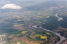
The section of the Rhine between Lake Constance and Basel is known as the Upper Rhine . This section largely forms the border between Germany and Switzerland . The Hochrhein-Bodensee planning region of the state of Baden-Württemberg is named after him.
General
The name Hochrhein was only introduced by science in the 19th century. Above all, the geologists endeavored to linguistically separate the Upper Rhine from the Upper Rhine. Before that one spoke at most of the "Baden-Swiss Rhine". The Upper Rhine begins at the outflow of the Rhine from the Untersee of Lake Constance near Stein am Rhein and merges into the Upper Rhine at the Basel Rhine knee . More accurate boundary point between the sub-basin Rheinsee the lower lake and the high Rhein is the Rhine bridge Stein am Rhein , defined as the endpoint applies Middle Bridge in Basel. The former is at river kilometer 25.45, the latter at kilometer 166.6; in between there are a good 141 kilometers of electricity.
In contrast to the Alpine Rhine and Upper Rhine , the Upper Rhine flows mainly to the west, falling from 395 m to 252 m. The flow rate increases from 364 m³ / s to 1037 m³ / s (for further data see : river system of the Rhine ). The valley is alternately broad-soled and narrowly indented . This is one of the reasons why the population density varies .
Larger tributaries of the High Rhine are Biber , Durach , Thur , Töss , Glatt , Wutach , Aare , Alb , Murg , Sissle , Wehra , Ergolz and Birs . It is noteworthy that at the confluence of the Aare in Koblenz (CH) it has more water (518 m³ / s) than the somewhat longer Rhine with 473 m³ / s. From a hydrological point of view, the Rhine is a tributary of the Aare.
Natural space
The German part of the High Rhine Valley is part of the natural spatial main unit group No. 16 ( High Rhine area ) in the south-west German layer level country . He leads No. 160 in the systematics of the manual of the natural spatial structure of Germany .
Waterfalls and rapids ("running")
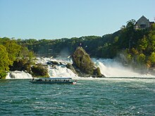
The relatively high gradient and the changes in course caused by the cold period facilitated the formation of several significant rapids ("running") on the Upper Rhine. First of all, the Upper Rhine in Neuhausen forms the largest waterfall in continental Europe when it meets a previously buried river channel , the Rhine Falls ( Großer Laufen ; Upper Jura ). It follows the Ettikoner Lauffen , also called Koblenzer Laufen (Upper Muschelkalk ) , above the Wutach estuary . At Laufenburg , the post-glacial deepening Rhine missed a previously sedimented drainage channel and met a branch of the Black Forest Crystalline. In it he cut the narrow Laufenburg rapids, the now blown up and overflowed Little Laufen . The Schwörstadter Laufen is also overflowing today . There is a shoal at Stein Castle near Rheinfelden , the St. Anna-Loch .
Cities and Landscapes
Well-known places and cities on the Upper Rhine (downstream) are ...
... on the Swiss side of the Upper Rhine: Stein am Rhein , Schaffhausen , Neuhausen am Rheinfall , Rheinau Monastery , Eglisau , Kaiserstuhl AG , Bad Zurzach , Koblenz AG , Laufenburg AG , Rheinfelden AG , Kaiseraugst , Pratteln , Muttenz and Basel
... on the German side of the High Rhine: Büsingen am Hochrhein , Jestetten , Lottstetten , Waldshut-Tiengen , Laufenburg (Baden) , Bad Säckingen , Rheinfelden and Grenzach-Wyhlen .
In the high Rhine area, which is often chambered by basins and side valleys, there are numerous current and historical landscape names . From west to east these are Dinkelberg , Augstgau , Fricktal , Tafeljura , Albgau , Aargau , Hotzenwald , Zurzibiet , Klettgau , Zürichgau and Thurgau .
Uses and interventions


The character of the river landscape was changed by the construction of hydropower plants over long distances. In connection with the original goal of making navigable, the big rapids near Laufenburg were blown up and dammed. See also → List of waterfalls in Germany .
The Upper Rhine still flows undamped between Stein am Rhein and Diessenhofen . The first river power plant of the High Rhine in Schaffhausen has its dam above Diessenhofen. The Rheinau diversion power plant follows around 7 km below the Rhine Falls . Its construction was preceded by violent protests in the 1950s, as the damming effect is visible up to the Rhine Falls. In addition, the Rhine loop at Rheinau Abbey is only bathed in water thanks to two auxiliary weirs. The next power plant is near Eglisau-Glattfelden . Its construction and the associated damming of the river made it necessary to demolish numerous houses and build the new Eglisau bridge over the Rhine between 1915 and 1920 . In the Oberriet district of Eglisau alone , for example, 15 of a total of 17 buildings had to be demolished. The Reckingen power plant follows about ten kilometers down the Rhine , after which the river flows back through the Koblenzer Laufen, after which the Aare takes in and meets the Albbruck-Dogern power plant at Leibstadt and Dogern . A further seven power plants will follow from here to Basel . The Upper Rhine has a total of eleven barrages with twelve river power plants (two at the Augst / Wyhlen barrage ).
The most important organizations for cross-border cooperation on the Upper Rhine are the High Rhine Commission and the High Rhine Agency .
Hydropower
There are a total of 11 barrages on the Upper Rhine.
| Barrage and power plant | Rhine km | Congestion destination [m aS] | Turbines | Flow rate [m³ / s] | operator |
|---|---|---|---|---|---|
| Schaffhausen | 45,350 | 390.80 | 2 | 1250 | Kraftwerk Schaffhausen AG |
| Rheinau | 55.3-59.6 | 359.00 | 2 | 400 | ENBW + Axpo |
| Eglisau-Glattfelden | 79.150 | 343.48 | 7th | 500 | Axpo |
| Reckingen power plant | 90.540 | 331.94 | 2 | 560 | Axpo + AEW + ENBW |
| Albbruck Dogern | 109.200 | 311.24 | 3 + 1 | 1100 | Radag |
| Laufenburg | 122.110 | 229.24 | 10 | 1370 | Energy service |
| Bad Säckingen | 129,370 | 289.69 | 4th | 1450 | Rheinkraftwerk Säckingen AG |
| Ryburg-Schwörstadt | 143.520 | 281.14 | 4th | 1460 | Ryburg-Schwörstadt AG power plant |
| Rheinfelden | 146.612 | 270.50 | 4th | 1500 | Energy service |
| Augst-Wyhlen | 155.550 | 261.00 | 2 + 7 | 750 | Energiedienst Holding |
| Birsfelden | 163.570 | 254.25 | 4th | 1300 | Birsfelden AG power plant |
shipping
The Hochrhein rafting was historically significant .
The green and white navigation signs , the so-called Wiffen, are typical of the Upper Rhine . They mark the fairway . Ships with a greater draft, such as the scheduled ships of the Swiss shipping company Untersee and Rhein, can only sail on the green side. To be on the safe side, boats with little draft, such as B. Weidlinge or rubber dinghies , kept driving on the white side. In Basel there is the Basler Personenschifffahrt . Large inland vessels can navigate the Upper Rhine from the Rhine port of Rheinfelden, both downstream and upstream. The Rhine port of Weil am Rhein is important for the economy and the Swiss Rhine ports for Switzerland .
See also → List of landing stages on the Upper Rhine
Inflatable ride
The Upper Rhine is often used by rubber dinghies in the summer months . Popular routes are from Stein am Rhein to Schaffhausen and from Rheinau to Eglisau . Driving on the Rhine with rubber dinghies in the area of the canton of Basel-Stadt is prohibited.
Rail connection
- Hochrheinbahn from Basel to Constance
- Railway line Turgi – Koblenz – Waldshut with the Rhine bridge Waldshut – Koblenz over the Upper Rhine
See also
- Shipping canal projects in the Alps , via u. a. unrealized canals that would have connected the Rhine with the Rhone or Po (river)
- Interregio Alpenrhein-Bodensee-Hochrhein
literature
- Manfred Fenzl: The Rhine. Schaffhausen - North Sea and the IJsselmeer. Inland Water Guide. 4th edition. Delius Klasing, Bielefeld 2005, ISBN 3-89225-466-4 .
- Andreas Gruschke : The Upper Rhine. An Alemannic river landscape. Schillinger, Freiburg im Breisgau 1995, ISBN 3891551835 .
- Manfred Bosch , Adelheid Enderle, Heinz Fricker, Reinhard Valenta: The Upper Rhine. Landscape and everyday life in old photographs. G. Braun, 1997, ISBN 3-7650-8157-4 .
- Horst Johannes Tümmers: The Rhine: a European river and its history . Beck, 2nd edition 1999 (1st 1994). Chapter 3: The Upper Rhine: a border that connects .
Web links
Individual evidence
- ↑ Reinhard Valenta: A landscape in change; The Upper Rhine between Waldshut and Rheinfelden. in: Bosch, MA Enderle, H. Fricker & R. Valenta: The Upper Rhine. G.Braun Verlag, Karlsruhe (1997) pp. 6-29
- ↑ Swiss Journal for Hydrology, Volumes 21-22, page 49: The end of the Untersee and thus the entire Lake Constance lies under the Rhine bridge at Stein.
- ↑ Horst Johannes Tümmers (1999): The Rhine: a European river and its history (p. 87)
- ^ Franz Lamprecht, Mario König : Eglisau. History of the bridge city on the Rhine . Chronos Verlag , Zurich 1992, ISBN 3-905311-01-1 , pp. 312-313.
- ↑ Eberle, Iwona. Rubber boat guide Switzerland. Thun: Werd Verlag, 2015. ISBN 978-3859327429
- ↑ Safely on the move on the Upper Rhine and Thur ( Memento of the original from August 5, 2016 in the Internet Archive ) Info: The archive link was inserted automatically and has not yet been checked. Please check the original and archive link according to the instructions and then remove this notice. to the Thurgau canton police
- ^ Website of the canton police in Basel-Stadt


