
Dinkelberg
| Dinkelberg | |
|---|---|
 Dinkelberg between Wiesental in the north-west and north, Wehratal in the east and Rhine valley in the south and south-west |
|
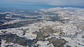
 View from the TV tower St. Chrischona northwards to the Black Forest |
|
| Highest peak | Hohe Flum ( 536.4 m above sea level ) |
| location | Districts Lörrach and Waldshut ; Baden-Württemberg ( Germany ) and Canton Basel-Stadt ( Switzerland ) |
| Coordinates | 47 ° 38 ′ N , 7 ° 49 ′ E |
| rock | Keuper and Muschelkalk |
 | |
Location of the Dinkelberg in Baden-Württemberg
|
The Dinkelberg is up to 536.4 m above sea level. NHN high, approximately 145 km² large, partially wooded mountain range in the High Rhine region in the districts of Lörrach and Waldshut in Baden-Württemberg ( Germany ) and to a smaller extent in the canton of Basel-Stadt ( Switzerland ). It is located on the southwestern edge of the southern Black Forest , from which it differs geologically.
geography
location
The Dinkelberg is mostly in the district of Lörrach, its eastern part in the area of the Wehra valley belongs to the district of Waldshut (both in Germany) and a small part in the west belongs to the canton of Basel-Stadt (Switzerland). It is bounded in the south by the valley of the High Rhine , in the north and west by the Wiesental and in the east by the Wehratal. It lies between the larger towns of Schopfheim in the north, Wehr in the east, Rheinfelden in the south and Lörrach with the Homburg Forest in the west. Its highest elevation is the Hohe Flum ( 536.4 m ), which has an open observation tower and the Hotel-Restaurant Hohe Flum.
Natural allocation and structure
The Dinkelberg forms - according to the systematics of the handbook of the natural spatial structure of Germany - in the natural spatial greater region Southwest German stepland as part of the main unit group high Rhine area (Dinkelberg and Hochrheintal) (No. 16) the subunit Dinkelberg (161). This is divided into the following natural areas: Dinkelberg southern slope (161.03) on the west and south-western slopes, western Dinkelberg plateau (161.00) in the west, central Dinkelberg (161.01) in the center, eastern Dinkelberg plateau (161.02) in the east and Lower Wehratal (161.10) on the eastern slope .
Top left in the picture quarter: Eastern tip of the Dinkelberg plateau between Wehratal (front) and Wiesental near Schopfheim (back), looking to the northwest
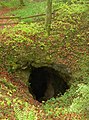
Teufelsloch , funnel doline near North Swabia
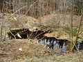
Trichterdoline Moosloch near Northern Swabia


mountains
The mountains, elevations and their foothills of the Dinkelberg include - sorted by height in meters (m) above sea level (NHN; D ) and meters above sea (m above sea level; CH ):
- Hohe Flum ( 536.4 m ; D), south-southwest of Wiechs ; with observation tower
- Hirzenleck ( 523.4 m ; D), 1 km north of Herten ; own tower with observation tower
- St. Chrischona ( 522 m ; CH), in Bettingen -St. Chrischona; u. a. with TV tower St. Chrischona
- Mauerhaldebuck ( 494.1 m ; D), southeast of Maulburg
- Mezelhöhe (Metzelhöhe; 487.2 m ; D), 2 km east-northeast of Salzert
- Eichberg ( 477.9 m ; D), northwest of Degerfelden
- Schachbühl ( 465.9 m ; D), 1.4 km north of Dossenbach
- Schindelberg ( 419 m ; D), east of Brombach
Waters
The flowing waters of the Dinkelberg include:
- the Bachtelengraben, which flows into the Rhine near Schwörstadt- Unterdorf,
- the Dürrenbach , which flows into the Rhine in Rheinfelden as well
- the Hagenbacher Bach and the Waidbach as source brooks of the Großbach (also called Warmbach ), which flows into the Rhine at Rheinfelden - Warmbach .
Among the standing water is one of at Schopfheim - Eichen location Eichener lake .
Nature and landscape protection
The German part of the Dinkelberg lies in the Southern Black Forest Nature Park . Several sub-areas belong to the Fauna-Flora-Habitat (FFH) area Dinkelberg and Röttler Wald . The nature reserves Buchswald near Grenzach , Buhrenboden , Buttenberghalde , Leuengraben and Ruschbachtal are entirely or partially in the Dinkelberg . The largest landscape protection areas are southwestern Dinkelberg in the west and Dinkelberg in the east near Wehr.
Natural monuments (selection)
- Eichener See near Schopfheim - Eichen
- Erdmannshöhle (also called Hasler Höhle ) on the outskirts of Hasel
- Teufelsloch , funnel doline near Rheinfelden - North Swabia
- Tschamberhöhle in Rheinfelden-Karsau, Riedmatt district
Localities
Cities and municipalities on and in the Dinkelberg area are (clockwise starting in the north):
|
|
geology
From a geological point of view, the Dinkelberg differs fundamentally from the Black Forest and the Swiss Jura . Its rock comes from the Middle Triassic era (247.2 to 235 million years ago) and is the relic of a flat sea that exists in large parts of today's Germany, in which thick layers of limestone were deposited over a period of several million years. These layers are rich in shell fossils, among other things. Therefore they are also summarized under the name Muschelkalk . When the Upper Rhine Plain began to emerge 45 million years ago, during the Tertiary Age , and the Black Forest rose up, all the rock layers that had been deposited up to that point were eroded away, down to the basement consisting of granite and gneiss . The less prominent clods of the Weitenau foothills and the Dinkelberg were spared from the complete erosion down to the bedrock, so that the Dinkelberg mainly consists of shell limestone. In several tectonic trenches nor is Keuper and somewhat Lower Jurassic get lower Keuper comes south Nordschwaben even in face preservation before. Gypsum from the middle Muschelkalk was mined in small tunnels both on the north side and on the south side (Wyhlen) of the Dinkelberg. South of the Dinkelberg, the middle Muschelkalk also contains rock salt, which used to be extracted for the chemical industry (south of the Rhine until today).
The Dinkelberg is classified as a karst area due to various erosion processes . Numerous, mostly underground erosion processes are still going on, which has led to natural monuments worth visiting. These include two stalactite caves, the Tschamberhöhle in Beuggen not far from the train station and the Erdmannshöhle on the outskirts of Hasel . This cave is particularly interesting because of its location in limestone layers on the edge of the fault to the Black Forest with its granites and gneisses .
Quite typical karst phenomena of the Dinkelberg are stream shrinkage (streams disappear in whirlpool holes, often in double valleys with stream shrinkage in the middle). The counterparts to this are spring pots, mostly located at the foot of steep slopes and sometimes in the immediate vicinity of houses or streets. Spring pots can be visited in Rheinfelden- Nollingen (the Dorfbach rises almost in front of the church, the Linsenbachquelle is located east of the village) and in Degerfelden ( Hagenbacher Hof area ). A special spring pot is located east of Schopfheim - Eichen . There, regardless of the short-term weather conditions, a hollow occasionally turns into Lake Eichen . The Dürrenbach also rises in the area of the ridge.
There are numerous sinkholes on the Dinkelberg . They are the result of dissolution phenomena or cave collapse of the shell limestone underground. One of the most well-known sinkholes is the Teufelsloch, a funnel line south-east of Northern Swabia , through whose ponor it is possible to enter a 75-meter-deep and 105-meter-long shaft cave. The Moosloch south of North Swabia is a funnel-shaped doline whose mouth was flooded and in the bottom of which a small boggy lake has formed.
literature
- Scientific contributions
- Friedrich Disch: Studies on the cultural geography of the Dinkelberg . Federal Institute for Regional Studies, Bad Godesberg 1971.
- Hermann Wider: The Dinkelberg. In: History Association Markgräflerland (Hrsg.): The Markgräflerland. Contributions to its history and culture. Schopfheim 2010, 1, pp. 4-46.
- Illustrated book
- Martin Koch, Reinhard Valenta: The Dinkelberg. Landscape island between the Rhine and the Black Forest , Waldemar Lutz Verlag, Lörrach 2001, ISBN 3-922107-53-2 .
Web links
- Natural area Dinkelberg No. 161 , natural area profile u. a. with model of natural space development (pp. 3–5), materials on the University of Stuttgart's landscape framework program, on lubw.baden-wuerttemberg.de (PDF; 6.2 MB)
- Interest group Dinkelberg (association of municipalities, clubs and associations in the Dinkelberg), on guten-vom-dinkelberg.de
- regionatur.ch: Dinkelberg
- Geology of the Dinkelberg (private website)
- Soils of the Dinkelberg
Individual evidence
- ↑ a b Map services of the Federal Agency for Nature Conservation ( information )
- ↑ Dinkelberg , landscape profile of the BfN
- ↑ Günther Reichelt: Geographical land survey: The natural spatial units on sheet 185 Freiburg i. Br. Federal Institute for Regional Studies, Bad Godesberg 1964. → Online map (PDF; 3.7 MB)
- ↑ State Institute for the Environment Baden-Württemberg (LUBW) ( information )