
Devil's hole (sinkhole)

Teufelsloch near North Swabia
The Teufelsloch on the Dinkelberg near North Swabia is a funnel doline around 40 meters deep with a continuation around 100 meters long.
description
The Teufelsloch is located in the area of a Unterkeuper dolphin zone in the Dornach forest area. The entrance funnel ends in a shaft about 20 meters deep. The surrounding soil drains through it, which, at a depth of around 10 meters, at the transition from the funnel to the shaft in the Upper Muschelkalk , has led to the formation of a striking, wide stalactite . Corridors under the sinkhole are 105 m wide and 75 m deep.

Teufelsloch, view up from the bottom of the sinkhole
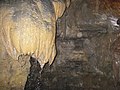
Stalactite at the transition from the funnel to the vertical part


Coordinates: 47 ° 36 ′ 20.1 ″ N , 7 ° 49 ′ 50.3 ″ E
Individual evidence
- ↑ Geotope profile of the sinkhole field in the Dornach forest area (PDF) on LGRB-GTP.
- ↑ Geotope profile of the Teufelsloch (PDF) on LGRB-GTP.
Web links
- "LGRB-GTP": Geoportal Baden-Württemberg ( information ), maps of the State Office for Geology, Raw Materials and Mining (LGRB), geotope cadastre