
Salzert
|
Salzert
City of Loerrach
Coordinates: 47 ° 36 ′ 15 ″ N , 7 ° 41 ′ 6 ″ E
|
|
|---|---|
| Height : | 400 m |
| Area : | 31.5 ha |
| Residents : | 2700 (2018) |
| Population density : | 8,571 inhabitants / km² |
| Postal code : | 79540 |
| Area code : | 07621 |
 Location of the Salzert in the urban area of Lörrach
|
|
The Salzert is a satellite settlement in the southeast of Lörrach . The Salzert had a total of around 2700 inhabitants in 2018. Its size and the existing infrastructure give the residential area, founded in 1963, the character of a district. After expansion of the area and an additional road connection in the 1970s and 1980s, the 1990s were characterized by a thorough renovation of many dilapidated residential buildings. The settlement structure of the Salzert is a mixture of multi-storey social housing in the southern part and single and multi-family houses in the northern part.
The center of the 31.5 hectare settlement area is 400 m above sea level. NN (shopping center).
Location and geography

In the area east of the Stetten district and south of the eastern core town, a former Allmendwiese , the settlement is surrounded by a lot of forest and nature. It is located like an island and thus somewhat isolated from the city on a plateau between the Gretherhof in the north, the 420 m high Skull Mountain in the west, the Maienbühl in the southwest and the Iron Hand in the south - a corner of the area that belongs to Switzerland but protrudes into Germany, the up to 480 m above sea level NN rises. The German-Swiss border , which runs south of the Salzert as a natural border through the forest, is only about 300 meters away from the southern part of the settlement area. The forest surrounding the Salzert is assigned to the Southern Black Forest Nature Park .
The approximately 31.5 hectare populated area of the Salzert has a north-west facing slope and extends at a height of 380 m to 450 m above sea level. NN . This means that the living space is a little over 100 meters above the valley floor of the meadow flowing through Lörrach . Geographically , the Salzert located on the ridge of the Dinkel Berg . Geologically , the living space is on a 200 meter thick layer of shell limestone , underneath a layer of red sandstone .

Panoramic view of the Salzert from the north (Unterer Wannenweg)

history
Surname

The exact meaning of the winning designation "Salzert" has not been passed down. However, the Salzert, Leuselhardt (formerly: Lüslert), Wilert, Vorengele and Rieder Wald formed the common part of a common forest of shoots. The ending “hard” or “herd” or “hardt” indicates that wood is used by shepherds' cooperatives. The winning designation "Vorengele" was already mentioned in 1660 by St. Albanberain as "before Engelins Reutin"; So it is the Reute - the reclaimed land - of a certain angel (hardt) and thus also a former forest floor.
planning phase
As early as 1952, the “Salzert” residential building project was run by the mayor of the time, Karl Arzet, in response to the great housing shortage. From the beginning there was talk of a "settlement for little people". By excluding real estate speculation, it was hoped that land would be cheap and affordable for large parts of the population. Initially, 800 building sites of 300 square meters each and a purchase price of 1500 DM were planned. According to the first calculations, Arzet commented on the housing project on March 12, 1953 as follows:
“The constant, unusually high population increase in the local border and district town of Lörrach is forcing the city administration to conduct an increasing survey every year to develop building land in order to meet the growing demand for building land. For this purpose, the urban area in Gewann "Salzert", formerly Allmendfeld, has to be developed as building land. According to the city architect's calculations, this requires a cost of 862,000 marks. "
In August 1953 there were subsoil investigations . The project was initially controversial among the population. This led to long discussions in the city parliament, which is why tenders were only held in January 1957. In addition to 450 private applicants in February 1957, Wohnbau Lörrach also registered as the client.
As early as 1958, a water tank was installed at the highest point in the future residential area. In November of the same year, an ideas competition “Waldsiedlung Salzert” was advertised, to which 18 draft contributions were submitted. The engineer Wolfgang Liebert from Schopfheim won the first prize . His plan was to divide the settlement area into two large residential areas, which should be encompassed by two ring roads in the southern part. In March 1959, the project was presented to the public at the Hebel Gymnasium . One of the biggest stumbling blocks was the technical route development. To build the stone road from Stetten, limestone foothills had to be blasted away over a length of 500 meters.
In February 1960, the overall planning was initially decided by the city council with twelve approvals and three abstentions. In June of the same year, the Freiburg regional council also agreed . The project was promoted by the then mayor Egon Hugenschmidt . As an advance payment, Steinenweg was expanded in 1962 as the only access road from Stetten at that time. The road, inaugurated on October 29, 1962, had cost 1.2 million DM and required 16,000 cubic meters of gravel sand . In the same year the common land use was completed.
Construction and opening
The groundbreaking took place on April 16, 1963 - in the same year the development of the Bühl in Brombach began a little later . The settlement, located on a mountain, was surrounded by the large community forest of Stettener Wald and at that time could only be reached via the stone path from the direction of Stetten. In this first of three construction phases, 1200 new apartments were built. The groundbreaking ceremony for the first three blocks of flats with a total of 78 apartments of Städtische Wohnbau took place on June 8th with the houses Röttelnblick 14-18. The first family was able to move to the Salzert in December 1964.
The infrastructural development of the settlement stalled when it became clear that the first house phone could not be activated until 1965. The reason for this was the cost of 200,000 marks for the necessary line network , which Deutsche Post was initially unable to bear. The Member of Parliament Walter Faller broached this problem in the then Bundestag in Bonn . On June 24, 1964, the first telephone booth was put into operation on the Salzert. At the beginning of the debate it was claimed that this would have to be sufficient for the population.
In the mid-1960s, when Lörrach was applying for a location for the University of Education, Lord Mayor Hugenschmidt considered using the farmland of the Gretherhof north of the Salzert for this purpose. Ultimately, however, this proposal was rejected and the Lörrach University of Education was built closer to the center in Lörrach.
On November 26, 1966, a kindergarten and community rooms were opened in the Luise-Schepper-Haus. A year later the planning of the shop center began. Construction of a neighboring high-rise began. A skyscraper, which was originally planned as a hotel, was eventually converted into an apartment building. In the 1960s, the Evangelical Church Community of Lörrach formed the Evangelical Peace and Salzert Congregation, which had around 1,000 members. The community center of the Friedensgemeinde was opened in May 1998 on the Salzert. On February 22 and 23, 1967, the Adolph Bermpohl hurricane triggered a disaster alarm. The storm tore off several roof sections of single and multi-family houses and caused further damage.
In the summer of 1967, the residential blocks of the municipal housing at Röttelnblick were completed. The construction of the shopping center began in May 1968. At that time there were 431 households; 1628 Lörrachers lived on the Salzert. After a 14-month construction period, the shopping center was opened in October 1969. At the same time, medical care was ensured by a doctor on site. In April 1970 a small post office and a restaurant opened .
Extensions in the 1970s and 1980s

At the beginning of the 1970s, the Catholic residents of Salzert were parish in Stetten . The ecumenical cooperation was remarkable. Since September 1972 there have been ecumenical services for the Salzert community in the Church of St. Fridolin .
In the 1970s, emerging plans to build eight to sixteen-story high-rise apartment buildings met with protest from the people of the Salzert. Ultimately, four eight-story log houses were built on the eastern edge of the forest near the elevated tank. A first construction stop due to an interim injunction by the Administrative Court was lifted in June 1974.
Last but not least, the ongoing construction and expansion of the residential area overloaded the only access road via Stetten. Therefore, at the end of the 1970s, an initiative was formed on the Salzert that called for the district to be connected to the city via Rheinfelder Straße and, after the expansion, to be linked to the B 316 . Thus, at the end of the 1980s, the Salzert received a second transport connection in the northwest via Salzertstrasse .
Change and renovation

Due to the dreary appearance of the buildings and visible construction defects, the Salzert was considered a social hotspot in the 1990s . Wohnbau Lörrach began to renovate the existing housing stock. The latest standards were taken into account for new buildings. The Dreispitz residential complex was completed in 1993 for around four million marks on a triangular piece of land right at the entrance to the Salzert settlement . In 1994 the residential complex received the German Builder Award .
In 2004 there were already 2625 residents in the Salzert. In 1997, Wohnbau Lörrach came to the following assessment in one area:
"If you take into account the expected development of the population structure, there is a risk that Salzert will be given the stigma of poverty and continue to move in a downward spiral."
The four prominent high-rise buildings on the edge of the forest were most at risk of being excluded as a focal point. Their demolition has been considered. The city of Loerrach invested over 13 million euros to prevent ghettos from forming. Housing was urgently needed in Lörrach. An expansion of the settlement area to the north has therefore been under discussion since the second half of the 2010s. An extension to the south is not possible for nature conservation reasons.
Townscape and infrastructure
Settlement area and buildings

In the southern part of the Salzert, multi-storey social housing units dominate . The tallest buildings are four multi-storey houses in the east, directly on the edge of the forest (Salzertstrasse 58-64), which are between 20 and 26 meters high. The four high-rise buildings offer a total of 164 apartments.
The Lörrach municipal housing estate owns 426 apartments in which around 1000 people live. To the southern residential area, Salzertstraße , which branches off from Landesstraße 141, leads in a ring shape , which divides the settlement area over two further streets that lead back to it. The Vorengele single-family house quarter is located in the northern part - the unusual name is taken from an old trade name . Both residential areas can be reached via two spur roads that branch off from Salzertstrasse in the north. Other connecting routes are only opened up by pedestrian and cycle paths.
Many houses on the Salzert were built in a terraced manner due to the length of the slope. This includes, among other things, the 1987 completed residential facility Röttelnblick, the 1988 Hugo Häring Award of the BDA Baden-Württemberg and the predicate "good buildings" BDA received.
Road sign
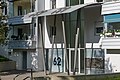
House Salzertstrasse 62
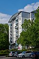
House Salzertstrasse 64
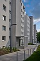
Houses Röttelnblick 63, 61 and 59


Economy and Infrastructure

On the Salzert there is a restaurant, a bakery as well as a small post office and a parcel acceptance point, housed in a centrally located shopping center. In addition, smaller businesses and service providers are located here. Opposite the shopping center there is a fountain, inaugurated in 1987, on the so-called street squat . It could be built through donations.
In addition to a kindergarten, there is the elementary school built in 1990/1991 , which has around 100 pupils. Since the 2014/2015 school year, it has also been functioning as a mandatory all-day school . The elementary school has a migration share of around 60% among its students. In 1996 a school gymnasium was built into which two classrooms are integrated. The main building offers six classrooms, one multi-purpose, two group rooms and several administration rooms. The school cooperates with the nearby Luise Scheppler kindergarten. The day-care center can accommodate around 100 children. The four kindergarten groups have between 22 and 25 children.
A youth meeting place and a district meeting place organized by the SAK Lörrach were set up on the Salzert . Various childcare options are offered there for children between the ages of 6 and 20. In 2010 the building was arson , but it was reopened in 2011.
Street stunts
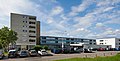
Shopping center

District meeting

Climbing wall at the elementary school


Since the Salzert does not have its own fire department, the Lörrach department of the main fire station stationed in Stetten is responsible for the area.
traffic

The Salzert is integrated into the local public transport system of the Regio Verkehrsverbund Lörrach and is served by the two bus lines 7 and 9. Line 7 runs between Lörrach Salzert and Lörrach Karl-Herbster-Platz in the north of the city and line 9 runs between Lörrach Salzert and Stetten-Süd. The bus stops at seven stops within the Salzert district .
Via the state road 141, the Salzert is connected to junction 6 ( Lörrach-Ost ) with the A98 , which arches past the satellite settlement from Lörrach to Rheinfelden . There is also a connection to the B 316 , which also leads to Rheinfelden via the Waidhof pass crossing .
As part of the Lörrach cycle route network (→ Radverkehr in Lörrach ), one cycle path leads north and south from the city center and from Stetten past the Salzert into the Herrenwald. The meeting bike paths lead either to the south of Inzlingen or to the west further into the Dinkelberg.
Others
The Lörrach Youth Hostel is located about half a kilometer east of the Salzert settlement area, on Steinenstrasse in the direction of Stetten . In the immediate vicinity of the hostel there has been a ropes course and a 500-meter-long Finnish lift in the forest south of the Salzert since 2007 . There is also a football pitch and a volleyball court to the west of the Salzert, in the direction of the skull mountain .
There is a collection point for green waste at the Gretherhof north of the Salzert. Also north of the Salzert is the Lörracher riding club.
Culture

The Salzert-Brettli theater group has existed since 1991 and has been a registered association since 1995. The approximately 20 active players have been performing a different play every year since 1991. The performances take place in the Max-Josef-Metzger -Haus.
In addition to performances by the theater group, ecumenical church and other leisure activities take place in the Max-Josef-Metzger-Haus. This event and community center , which is supported by the Catholic Church, was inaugurated in December 1990, is located next to the primary school and has a church service room, another hall with a stage and two group rooms with a kitchen. The primary school partly uses the space in the Max-Josef-Metzger-Haus.
literature
- Walter Franke: The Salzert and its 25-year history. In: Our Lörrach 1977. A border town in the mirror of time. , Volume 8, Loerrach 1977, pp. 33-42.
- Otto Wittmann et al., City of Lörrach (Hrsg.): Lörrach: Landscape - History - Culture . Verlag Stadt Lörrach, Lörrach 1983, ISBN 3-9800841-0-8 , pp. 41-46 u. Pp. 513-515.
- Landesarchivdirektion Baden-Württemberg, Landkreis Lörrach (ed.): Der Landkreis Lörrach , Volume II (Kandern to Zell im Wiesental), Jan Thorbecke Verlag Sigmaringen 1994, ISBN 3-7995-1354-X , pp. 93-94.
Web links
- Regional information system for Baden-Württemberg (LeoBW): Salzert - living space - archive material
- The Upper Baden : Is the Salzert overwhelmed? , Article dated February 12, 2018
- Housing Lörrach: Salzert - living space with mountain air - brief portrait of the Salzert residential area
- Aerial photo of the Salzert district ( Memento from September 5, 2014 in the Internet Archive )
- Ortho recordings of the Salzert: 1953 (with the undeveloped common area) and 1976
Individual evidence
- ↑ Walter Franke: The Salzert and his 25-year history , p. 33.
- ^ Walter Jung, Gerhard Moehring : Our Lörrach 1982. A border town in the mirror of time. Lörrach, 1982, p. 31.
- ^ Karl Herbster: Lörracher historical memories. , Rebmann, Lörrach 1948, p. 50.
- ↑ Walter Franke: The Salzert and his 25-year history , p. 34.
- ↑ a b Otto Wittmann et al., City of Lörrach (Hrsg.): Lörrach: Landscape - History - Culture. P. 42.
- ↑ Walter Franke: The Salzert and his 25-year history , p. 35.
- ↑ a b Walter Franke: The Salzert and his 25-year history , p. 36.
- ↑ Walter Franke: The Salzert and his 25-year history , p. 37.
- ↑ Wittmann et al., City of Lörrach (ed.): Lörrach: Landscape - History - Culture. P. 536.
- ↑ a b Walter Franke: The Salzert and his 25-year history , p. 38.
- ↑ Description of the Evangelical Salzert Congregation , last accessed on May 17, 2019
- ↑ Evangelical Church Community Lörrach: Salzertgemeinde , last accessed on May 17, 2019
- ↑ a b Walter Franke: The Salzert and his 25-year history , p. 39.
- ↑ Walter Franke: The Salzert and his 25-year history , p. 40.
- ^ German builder award: German builder award. High quality - affordable housing costs. Lörrach, “Dreispitz” residential complex, Fridolin-Engel-Straße . , last accessed on May 28, 2019
- ^ Wüstenrot Foundation and German-French Institute (ed.): Lörrach: Social quarter management as a second chance for social housing estates. in Urban Development and Integration of Young People in Germany and France , Wüstenrot Foundation, 2010, ISBN 978-3-933249-71-5 , p. 135 (PDF, p. 5).
- ↑ Die Oberbadische : Is the Salzert overwhelmed? , Article dated February 12, 2018, last accessed May 17, 2019
- ↑ Südkurier: Take a deep breath at the citizens' initiative: Lörracher Salzert-Süd will not be a building area , article from June 5, 2017, accessed on July 3, 2019
- ↑ Housing Lörrach: Living space with mountain air (PDF), p. 1.
- ^ Housing Lörrach : Salzert - living space with mountain air , last accessed on May 17, 2019
- ↑ Röttelnblick Lörrach , last accessed on May 28, 2019
- ^ Salzert primary school: The Salzert primary school , last accessed on May 17, 2019
- ↑ Available space at the Salzert Kindergarten , last accessed on May 27, 2019
- ^ Badische Zeitung : After the fire: Salzert district meeting opens again , article from March 19, 2011, last accessed on May 27, 2019
- ↑ Information on the ropes course , accessed on July 3, 2019
- ↑ Salzert-Brettli: Wir über uns , last accessed on May 17, 2019
- ↑ Salzert-Brettli: Program archive , last accessed on May 17, 2019
- ↑ Catholic Church Lörrach: Discussion group on the Salzert , last accessed on May 27, 2019
- ↑ City of Lörrach: Max-Josef-Metzger Haus , last accessed on May 27, 2019
- ^ Lörrach Catholic Church: Churches and Parish Halls , last accessed on May 27, 2019
