Tüllingen
|
Tüllingen
City of Loerrach
|
|
|---|---|
| Coordinates: 47 ° 36 '0 " N , 7 ° 39' 0" E | |
| Height : | 350-460 m above sea level NHN |
| Area : | 2.08 km² |
| Residents : | 1430 (2009) |
| Population density : | 688 inhabitants / km² |
| Incorporation : | October 1, 1935 |
| Postal code : | 79539 |
| Area code : | 07621 |
|
Tüllingen district
|
|
Tüllingen ( Alemannisch : Düllige ) is on the same Tüllinger Berg preferred Lörracher district. The two parts of the village, Ober- and Untertüllingen , were merged into one district in 1935.
geography
Location and structure

The geologically significant Tüllinger Berg (called Tüllinger for short , Tüllinger Hügel in Switzerland ) rises in the southern part to a maximum height of 460.2 m above sea level. NHN and offers views of the border triangle , the knee of the Rhine and the surrounding cities of Lörrach, Weil am Rhein and Basel .
Neighboring communities
In the south, Tüllingen borders the Swiss border with the village of Riehen . To the southwest is Stetten , a little further north is the core town of Lörrach. In the north and north-west are Tumringen , and the districts of Ötlingen and Haltingen belonging to Weil am Rhein . In the southwest, still on the slope of the Tüllinger Berg, the settlement of Alt-Weil begins.
history
The first documentary mention goes back to the year 1113. There a Walcho von Waldeck is specifically mentioned, who donated his property to the St. Blasien Monastery . The first mention of Tülliken indicates a settlement that may be derived from a personal name. Furthermore, the place is in 1173 in a letter of protection for St. Blasien of the then Pope Kalixt III. called, in which the Tüllinger church and other possessions are mentioned. The village subsequently developed as a road to Rötteln .
Like other places in the area, Tüllingen was also affected by the effects of the Thirty Years War and the destruction of Rötteln in 1678. On October 14, 1702, the battle at the Käferholz took place on Tüllinger Boden , which caused considerable damage to the place. In 1767 the first water supply came from a spring discovered between Ober- and Niedertüllingen. In the same year the borders after Rötteln were confirmed. In the 17th and 18th centuries, Tüllingen had disputes with the neighboring villages.
The two parts of the village, Ober- and Untertüllingen, were incorporated into Lörrach in 1935 and merged into one district.
coat of arms
The coat of arms of Tüllingen bears two crossed golden swords on a blue background. The coat of arms was introduced in 1902 and commemorates the battle of the Käferholz on October 14, 1702.
Population development
The historical population development of the village of Tüllingen only increased slightly over the centuries and only increased sharply with the incorporation of the village into Lörrach in 1935. The numbers in italics represent estimates. From 1872, the civil registration of the inhabitants took place.
|
|
Buildings

The Tüllingerhöhe children's home is located in Obertüllingen . The Evangelical Church is responsible for the home. The home includes the administration building, large kitchen and school for educational assistance, which is made up of elementary, secondary, special schools and a secondary school up to the seventh grade. In addition, eight residential groups, therapeutic offers, a sports hall and a sports field are part of the facility. Two of the residential groups belonging to the children's home are located in Untertüllingen.
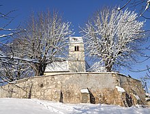
The public village school Adolf Glattacker Primary School was located in Untertüllingen until 2004 . The former school building is now used by the village community as a cultural center, which is used by associations and the polling station. There is also a public kindergarten of the Protestant church in the center of Untertüllingen. The local church itself is the old St. Ottilien Church in Obertüllingen, which is illuminated in the evening and can be seen from afar.
The Lörrach transmitter is also located in Obertüllingen .
traffic
The two district towns of Lörrach and Weil am Rhein are separated by the Tüllinger Berg. The steep, serpentine road between the two cities functions as a pass road. This means that the crossing between the two neighboring cities is the only road across the southern Tüllinger Berg. Starting from Alt-Weil, the road overcomes a height difference of 100 meters in two hairpin bends over 1.8 kilometers , which corresponds to an average gradient of 5.8%. The apex of the Untertüllingen pass at 381 m is reached shortly before the southern entrance to the lower part of the village. From there a cul-de-sac branches off to Obertüllingen and Lindenplatz. The north ramp starting from the Wiesenbrücke in Lörrach also overcomes 100 vertical meters with a hairpin over 2.2 kilometers, which corresponds to an average gradient of 4.5%.
Next to the road up to Tüllingen, a 864 m long railway tunnel built between 1888 and 1890 connects the two cities.
For decades there have been efforts to connect the two cities by means of the duty-free road leading partly through Swiss territory , in order to avoid the route through or over the Tüllinger. (→ Bundesstrasse 317 ). The duty-free road finally opened in October 2013.
Personalities
- Adolf Glattacker (1878–1971), German painter and draftsman
- Hans-Peter Schwarz (historian) , was buried in Obertüllingen
literature
- City of Lörrach (Ed.): Our Lörrach 1972, a border town in the mirror of time. Kropf and Herz Verlag, Lörrach 1973.
- In this yearbook several articles are dedicated to the Tüllingen district, including:
- Gerhard Moehring : Leafed through the Tüllingen church book for 300 years. Pp. 16-25.
- Gerhard Moehring: The pastors of Tüllingen since the Reformation. Pp. 26-28.
- Albert Vögtlin: The old Tüllinger families. Pp. 37-44.
- Inge Gula: field names of the old Tüllingen district. Pp. 62-104.
- Landesarchivdirektion Baden-Württemberg, Landkreis Lörrach (ed.): Der Landkreis Lörrach , Volume II (Kandern to Zell im Wiesental), Jan Thorbecke Verlag Sigmaringen 1994, ISBN 3-7995-1354-X , pp. 160–162.
- Wolfgang Göckel (Red.): Lörrach 2013 , Waldemar Lutz Verlag, Lörrach 2013, ISBN 978-3-922107-98-9 . (Main topic Tüllingen)
Web links
- Regional information system for Baden-Württemberg (LeoBW): Obertüllingen - living space - archive material
- German Digital Library : Digitized objects on Tüllingen
- Tüllinger and Weindorf Tüllingen
Individual evidence
- ↑ Map services of the Federal Agency for Nature Conservation ( information )
- ^ Landesarchivdirektion Baden-Württemberg, Landkreis Lörrach (ed.): Der Landkreis Lörrach , Volume II (Kandern to Zell im Wiesental), Jan Thorbecke Verlag Sigmaringen 1994, ISBN 3-7995-1354-X , p. 160.
- ^ Moehring: leafed through the Tüllingen church book for 300 years . P. 22.
- ↑ http://www.verlagshaus-jaumann.de/inhalt.loerrach-chronist-der-adenauer-zeit.78a4aab0-d333-4f25-992a-2ac572a42e9c.html


